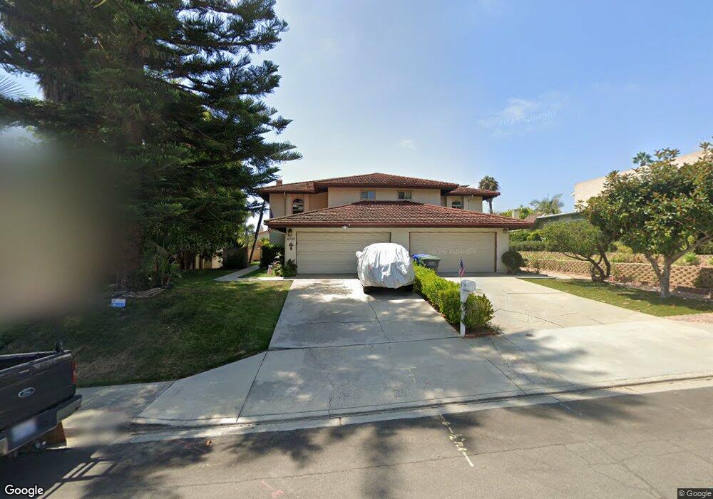
6733 Cantil St Carlsbad, CA 92009
La Costa NeighborhoodEstimated Value: $1,099,284 - $1,256,000
3
Beds
3
Baths
2,224
Sq Ft
$531/Sq Ft
Est. Value
About This Home
This home is located at 6733 Cantil St, Carlsbad, CA 92009 and is currently estimated at $1,180,071, approximately $530 per square foot. 6733 Cantil St is a home located in San Diego County with nearby schools including La Costa Meadows Elementary, San Elijo Middle School, and San Marcos High School.
Ownership History
Date
Name
Owned For
Owner Type
Purchase Details
Closed on
Jan 26, 1996
Sold by
Roper Charles Austin and Roper Kiyoko
Bought by
Roper Charles A and Roper Kiyoko
Current Estimated Value
Purchase Details
Closed on
Jun 28, 1988
Purchase Details
Closed on
Feb 2, 1983
Create a Home Valuation Report for This Property
The Home Valuation Report is an in-depth analysis detailing your home's value as well as a comparison with similar homes in the area
Home Values in the Area
Average Home Value in this Area
Purchase History
| Date | Buyer | Sale Price | Title Company |
|---|---|---|---|
| Roper Charles A | -- | -- | |
| -- | $166,000 | -- | |
| -- | $135,000 | -- |
Source: Public Records
Tax History
| Year | Tax Paid | Tax Assessment Tax Assessment Total Assessment is a certain percentage of the fair market value that is determined by local assessors to be the total taxable value of land and additions on the property. | Land | Improvement |
|---|---|---|---|---|
| 2025 | $3,830 | $317,702 | $86,861 | $230,841 |
| 2024 | $3,830 | $311,473 | $85,158 | $226,315 |
| 2023 | $3,705 | $305,367 | $83,489 | $221,878 |
| 2022 | $3,607 | $299,380 | $81,852 | $217,528 |
| 2021 | $3,513 | $293,511 | $80,248 | $213,263 |
| 2020 | $3,455 | $290,503 | $79,426 | $211,077 |
| 2019 | $3,439 | $284,808 | $77,869 | $206,939 |
| 2018 | $3,361 | $279,225 | $76,343 | $202,882 |
| 2017 | $3,301 | $273,751 | $74,847 | $198,904 |
| 2016 | $3,262 | $268,384 | $73,380 | $195,004 |
| 2015 | $3,175 | $264,353 | $72,278 | $192,075 |
| 2014 | $3,080 | $259,176 | $70,863 | $188,313 |
Source: Public Records
Map
Nearby Homes
- 6712 Cantil St
- 6705 Antilope St
- 2647 Cazadero Dr
- 2811 Unicornio St
- 2851 Cebu Place
- 2718 Socorro Ln
- 6663 Sitio Palmas
- 6429 La Vanco Ct
- 6827 El Fuerte St
- 6801 6803 El Fuerte St
- 7133 Obelisco Cir
- 7146 Argonauta Way
- 2518 Unicornio St
- 6673 Corte Maria
- 7049 El Fuerte St
- 6433 La Paloma St
- 6971 Ballena Way Unit 2
- 3211 Sirena Vista Way Unit 116
- 2829 Carrillo Way
- 2266 Aventurine Place
- 6735 Cantil St
- 6727 Cantil St
- 6729 Cantil St
- 6726 Antilope St Unit 28
- 6724 Antilope St Unit 2
- 6722 Antilope St
- 6721 Cantil St
- 6723 Cantil St
- 6730 Antilope St Unit U1
- 6740 Cantil St
- 6736 Cantil St
- 6734 Cantil St
- 6718 Antilope St Unit 1
- 6728 Cantil St
- 2705 Anta Ct
- 6734 Antilope St
- 6717 Cantil St
- 2737 Abejorro St
- 2733 Abejorro St
- 2735 Abejorro St
Your Personal Tour Guide
Ask me questions while you tour the home.