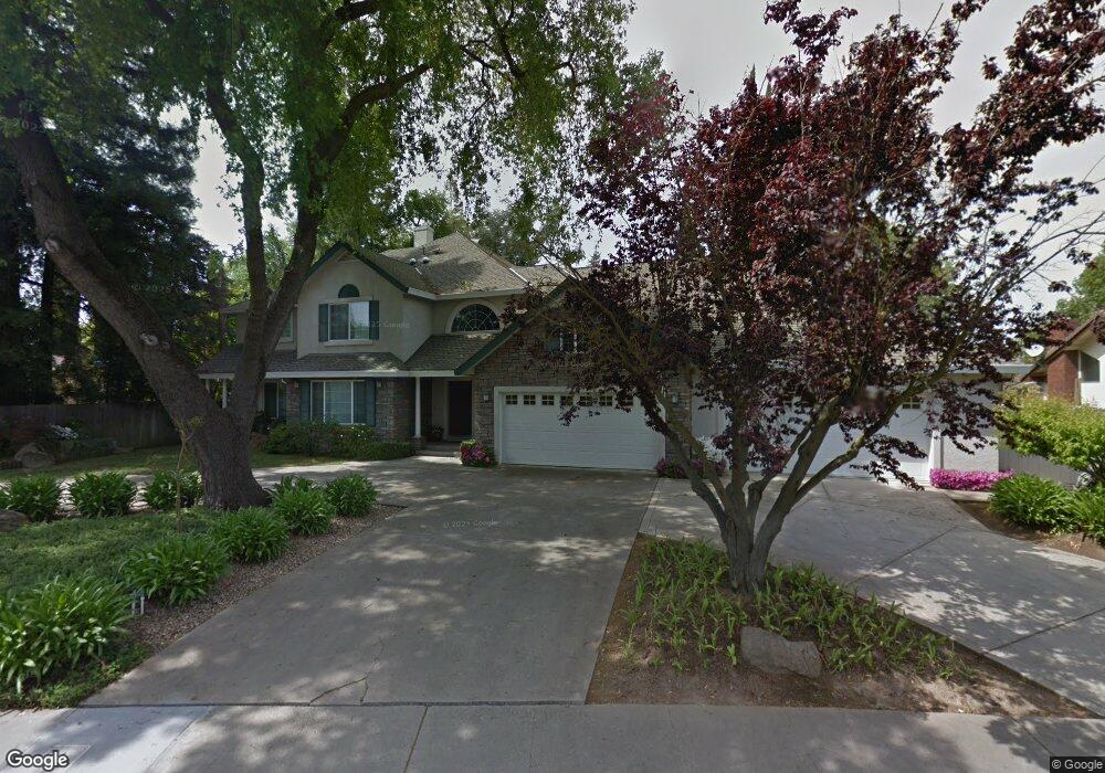
6742 Benham Way Sacramento, CA 95831
Pocket-Greenhaven NeighborhoodEstimated Value: $763,000 - $1,061,779
4
Beds
4
Baths
3,394
Sq Ft
$252/Sq Ft
Est. Value
About This Home
This home is located at 6742 Benham Way, Sacramento, CA 95831 and is currently estimated at $856,195, approximately $252 per square foot. 6742 Benham Way is a home located in Sacramento County with nearby schools including Genevieve Didion School, Sam Brannan Middle School, and John F. Kennedy High School.
Ownership History
Date
Name
Owned For
Owner Type
Purchase Details
Closed on
Feb 22, 2025
Sold by
Ross Randall L and Ross Juliette L
Bought by
Ross Family Trust and Ross
Current Estimated Value
Purchase Details
Closed on
Oct 12, 1998
Sold by
Lucille M Omand Trust and Lucille M
Bought by
Ross Randall and Ross Juliette
Purchase Details
Closed on
Aug 2, 1994
Sold by
Omand Lucille M
Bought by
Omand Lucille M and Lucille M Omand Trust
Create a Home Valuation Report for This Property
The Home Valuation Report is an in-depth analysis detailing your home's value as well as a comparison with similar homes in the area
Home Values in the Area
Average Home Value in this Area
Purchase History
| Date | Buyer | Sale Price | Title Company |
|---|---|---|---|
| Ross Family Trust | -- | None Listed On Document | |
| Ross Family Trust | -- | None Listed On Document | |
| Ross Randall | $200,000 | Fidelity National Title Co | |
| Omand Lucille M | -- | -- |
Source: Public Records
Tax History
| Year | Tax Paid | Tax Assessment Tax Assessment Total Assessment is a certain percentage of the fair market value that is determined by local assessors to be the total taxable value of land and additions on the property. | Land | Improvement |
|---|---|---|---|---|
| 2025 | $6,504 | $541,009 | $90,133 | $450,876 |
| 2024 | $6,504 | $530,402 | $88,366 | $442,036 |
| 2023 | $6,334 | $520,003 | $86,634 | $433,369 |
| 2022 | $6,263 | $509,808 | $84,936 | $424,872 |
| 2021 | $5,953 | $499,813 | $83,271 | $416,542 |
| 2020 | $5,993 | $494,689 | $82,418 | $412,271 |
| 2019 | $5,865 | $484,990 | $80,802 | $404,188 |
| 2018 | $5,713 | $475,481 | $79,218 | $396,263 |
| 2017 | $5,625 | $466,159 | $77,665 | $388,494 |
| 2016 | $5,485 | $457,020 | $76,143 | $380,877 |
| 2015 | $5,363 | $450,156 | $75,000 | $375,156 |
| 2014 | $5,235 | $441,339 | $73,531 | $367,808 |
Source: Public Records
Map
Nearby Homes
- 151 Audubon Cir
- 6742 Park Riviera Way
- 6797 Frates Way
- 6573 Park Riviera Way
- 353 Deer River Way
- 231 Portinao Cir
- 8 Kathy Ct
- 217 Roundtree Ct
- 334 River Isle Way
- 19 Waters Cove Ct
- 14 Rose River Ct
- 28 Keel Ct
- 20 Keel Ct
- 534 Valim Way
- 10 Park West Ct
- 672 Clipper Way
- 6241 Riverside Blvd Unit 220
- 6241 Riverside Blvd
- 7351 Perera Cir
- 10 Capay Ct
- 6770 Arabella Way
- 6728 Benham Way
- 6780 Arabella Way
- 6714 Benham Way
- 6745 Benham Way
- 6721 Benham Way
- 6790 Arabella Way
- 6761 Arabella Way
- 6771 Arabella Way
- 6700 Benham Way
- 6745 Harmon Dr
- 6707 Benham Way
- 6781 Arabella Way
- 6749 Arabella Way
- 6800 Arabella Way
- 6725 Harmon Dr
- 6791 Arabella Way
- 6750 Trudy Way
- 6683 Benham Way
- 6760 Trudy Way
Your Personal Tour Guide
Ask me questions while you tour the home.