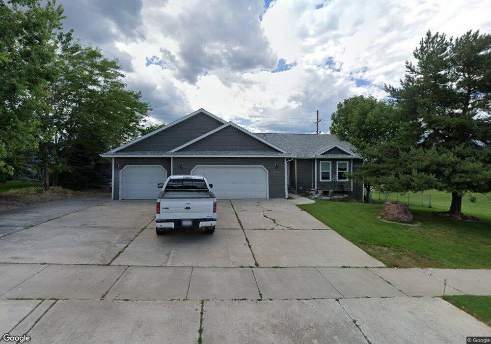
6771 Kelsey Ct Missoula, MT 59803
Miller Creek NeighborhoodEstimated Value: $643,141 - $738,000
3
Beds
2
Baths
1,606
Sq Ft
$422/Sq Ft
Est. Value
About This Home
This home is located at 6771 Kelsey Ct, Missoula, MT 59803 and is currently estimated at $677,535, approximately $421 per square foot. 6771 Kelsey Ct is a home located in Missoula County with nearby schools including Jeannette Rankin Elementary School, Porter Middle School, and Sentinel High School.
Ownership History
Date
Name
Owned For
Owner Type
Purchase Details
Closed on
Jul 18, 2005
Sold by
Sept Jeffrey L and Wagener Leslie K
Bought by
Frojen Wendell and Frojen Dorothy
Current Estimated Value
Home Financials for this Owner
Home Financials are based on the most recent Mortgage that was taken out on this home.
Original Mortgage
$215,200
Outstanding Balance
$111,246
Interest Rate
5.51%
Mortgage Type
Fannie Mae Freddie Mac
Estimated Equity
$566,289
Purchase Details
Closed on
Oct 31, 2003
Sold by
Welling Edward A and Welling Jennifer
Bought by
Sept Jeffrey L and Wagener Leslie K
Create a Home Valuation Report for This Property
The Home Valuation Report is an in-depth analysis detailing your home's value as well as a comparison with similar homes in the area
Home Values in the Area
Average Home Value in this Area
Purchase History
| Date | Buyer | Sale Price | Title Company |
|---|---|---|---|
| Frojen Wendell | -- | -- | |
| Sept Jeffrey L | -- | -- |
Source: Public Records
Mortgage History
| Date | Status | Borrower | Loan Amount |
|---|---|---|---|
| Open | Frojen Wendell | $215,200 |
Source: Public Records
Tax History Compared to Growth
Tax History
| Year | Tax Paid | Tax Assessment Tax Assessment Total Assessment is a certain percentage of the fair market value that is determined by local assessors to be the total taxable value of land and additions on the property. | Land | Improvement |
|---|---|---|---|---|
| 2025 | $6,556 | $610,600 | $111,576 | $499,024 |
| 2024 | $6,227 | $512,800 | $92,235 | $420,565 |
| 2023 | $6,054 | $511,700 | $92,235 | $419,465 |
| 2022 | $5,068 | $371,000 | $0 | $0 |
| 2021 | $4,507 | $371,000 | $0 | $0 |
| 2020 | $4,460 | $350,800 | $0 | $0 |
| 2019 | $4,447 | $350,800 | $0 | $0 |
| 2018 | $4,119 | $315,100 | $0 | $0 |
| 2017 | $4,050 | $315,100 | $0 | $0 |
| 2016 | $3,469 | $283,300 | $0 | $0 |
| 2015 | $3,201 | $283,300 | $0 | $0 |
| 2014 | $3,061 | $151,368 | $0 | $0 |
Source: Public Records
Map
Nearby Homes
- 6770 Roberta Dr
- 4543 Christian Dr
- 4800 Jaiden Ln
- 6520 Danielle Lou Ct
- 4750 Mark Ct
- 5047 Roy Ct
- 4434 Harrison Scott Dr
- 6650 Linda Vista Blvd
- 4388 Harrison Scott Dr
- 4863 Scott Allen Dr
- Linda Vista Blvd Linda Vista Blvd
- 4345 Christian Dr
- 4060 Jamie Ann Ln
- 6250 Timothy Ct
- 7155 Brooke Lynn Ct
- Nhn Avery Ln
- 5050 Jordan Ct
- 5207 Frazer Ct
- 7083 Shaver Dr
- 7123 Shaver Dr
- 6781 Kelsey Ct
- 6781 Kelsey Ct
- 6655 Cam Ct
- 4644 Christian Dr
- 6751 Kelsey Ct
- 6660 Cam Ct
- 6750 Roberta Dr
- 4652 Christian Dr
- 6675 Cam Ct
- 6755 Roberta Dr
- 6744 Kelsey Ct
- 6741 Kelsey Ct
- 6680 Cam Ct
- 4668 Christian Dr
- 4604 Christian Dr
- 6685 Cam Ct
- 6786 Roberta Dr
- 6734 Kelsey Ct
- 6809 Kelsey Ct
- 6773 Roberta Dr