Estimated Value: $293,000 - $321,000
3
Beds
2
Baths
1,366
Sq Ft
$224/Sq Ft
Est. Value
About This Home
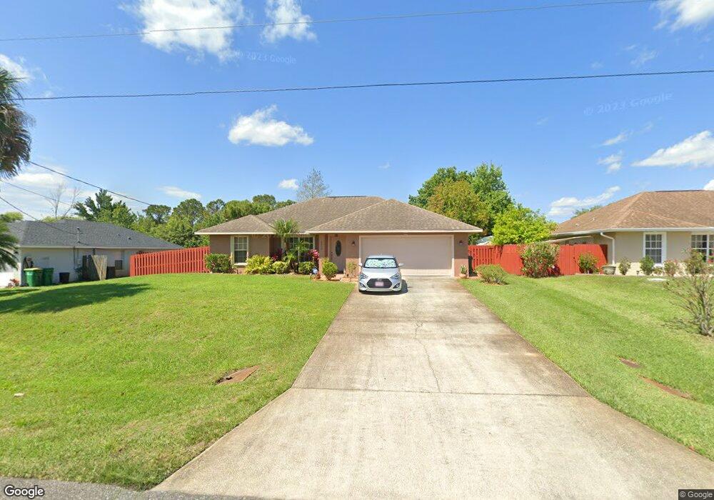
This home is located at 6800 Bryant Rd, Cocoa, FL 32927 and is currently estimated at $306,258, approximately $224 per square foot. 6800 Bryant Rd is a home located in Brevard County with nearby schools including Enterprise Elementary School, Space Coast Junior/Senior High School, and Sculptor Charter School.
Ownership History
Date
Name
Owned For
Owner Type
Purchase Details
Closed on
Apr 9, 2007
Sold by
Nazario Robert and Nazario Eileen L
Bought by
Valdes Antonio M and Valdes Alicia M
Current Estimated Value
Home Financials for this Owner
Home Financials are based on the most recent Mortgage that was taken out on this home.
Original Mortgage
$173,500
Outstanding Balance
$104,903
Interest Rate
6.15%
Estimated Equity
$201,355
Purchase Details
Closed on
Jan 10, 2003
Sold by
Lim Kae Joo and Lim Young Ja
Bought by
Nazario Robert
Purchase Details
Closed on
May 20, 1996
Sold by
Nationsbank Fl N A
Bought by
Lim Kae Joo and Lim Young Ja
Create a Home Valuation Report for This Property
The Home Valuation Report is an in-depth analysis detailing your home's value as well as a comparison with similar homes in the area
Home Values in the Area
Average Home Value in this Area
Purchase History
| Date | Buyer | Sale Price | Title Company |
|---|---|---|---|
| Valdes Antonio M | $193,500 | State Title Partners Llp | |
| Nazario Robert | $10,000 | -- | |
| Lim Kae Joo | $6,100 | -- |
Source: Public Records
Mortgage History
| Date | Status | Borrower | Loan Amount |
|---|---|---|---|
| Open | Valdes Antonio M | $173,500 |
Source: Public Records
Tax History
| Year | Tax Paid | Tax Assessment Tax Assessment Total Assessment is a certain percentage of the fair market value that is determined by local assessors to be the total taxable value of land and additions on the property. | Land | Improvement |
|---|---|---|---|---|
| 2025 | $1,213 | $91,410 | -- | -- |
| 2024 | $1,178 | $88,840 | -- | -- |
| 2023 | $1,178 | $86,260 | $0 | $0 |
| 2022 | $1,094 | $83,750 | $0 | $0 |
| 2021 | $1,085 | $81,320 | $0 | $0 |
| 2020 | $1,033 | $80,200 | $0 | $0 |
| 2019 | $967 | $78,400 | $0 | $0 |
| 2018 | $958 | $76,940 | $0 | $0 |
| 2017 | $948 | $75,360 | $0 | $0 |
| 2016 | $955 | $73,810 | $18,000 | $55,810 |
| 2015 | $965 | $73,300 | $15,000 | $58,300 |
| 2014 | $970 | $72,720 | $11,000 | $61,720 |
Source: Public Records
Map
Nearby Homes
- 6815 Bryant Rd
- 6760 Cairo Rd
- 7065 Hundred Acre Dr
- 6615 Dock Ave
- 5555 Brandon St
- 6990 Bryant Rd
- 5155 Mayflower St
- 5165 Patricia St
- 6581 Bancroft Ave
- 5075 Carter St
- 00 Unknown
- 6450 Ember Ave
- 5080 Mayflower St
- 5680 Brandon St
- 6620 Grissom Pkwy
- 7230 Venus Ave
- 6481 La Brea Ave
- 5200 Frisco St
- 7200 Oakwood Ave
- 6438 Hudson Rd
Your Personal Tour Guide
Ask me questions while you tour the home.