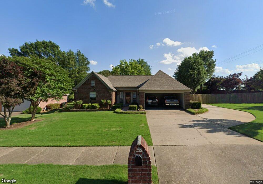
6823 Andrews Rd Memphis, TN 38135
Estimated Value: $275,000 - $295,000
3
Beds
2
Baths
1,436
Sq Ft
$198/Sq Ft
Est. Value
About This Home
This home is located at 6823 Andrews Rd, Memphis, TN 38135 and is currently estimated at $283,722, approximately $197 per square foot. 6823 Andrews Rd is a home located in Shelby County with nearby schools including Oak Elementary School, Appling Middle School, and Bartlett High School.
Ownership History
Date
Name
Owned For
Owner Type
Purchase Details
Closed on
Oct 6, 2004
Sold by
Flanagan James D and Flanagan Nessie O
Bought by
Vaden Gary W and Vaden Lynette
Current Estimated Value
Home Financials for this Owner
Home Financials are based on the most recent Mortgage that was taken out on this home.
Original Mortgage
$136,000
Outstanding Balance
$67,264
Interest Rate
5.75%
Mortgage Type
Unknown
Estimated Equity
$216,458
Create a Home Valuation Report for This Property
The Home Valuation Report is an in-depth analysis detailing your home's value as well as a comparison with similar homes in the area
Home Values in the Area
Average Home Value in this Area
Purchase History
| Date | Buyer | Sale Price | Title Company |
|---|---|---|---|
| Vaden Gary W | $146,000 | Edco Title & Closing Service |
Source: Public Records
Mortgage History
| Date | Status | Borrower | Loan Amount |
|---|---|---|---|
| Open | Vaden Gary W | $136,000 |
Source: Public Records
Tax History Compared to Growth
Tax History
| Year | Tax Paid | Tax Assessment Tax Assessment Total Assessment is a certain percentage of the fair market value that is determined by local assessors to be the total taxable value of land and additions on the property. | Land | Improvement |
|---|---|---|---|---|
| 2025 | $1,644 | $69,325 | $14,500 | $54,825 |
| 2024 | $1,644 | $48,500 | $9,750 | $38,750 |
| 2023 | $2,483 | $48,500 | $9,750 | $38,750 |
| 2022 | $2,483 | $48,500 | $9,750 | $38,750 |
| 2021 | $2,522 | $48,500 | $9,750 | $38,750 |
| 2020 | $1,532 | $37,825 | $7,500 | $30,325 |
| 2019 | $2,224 | $37,825 | $7,500 | $30,325 |
| 2018 | $2,224 | $37,825 | $7,500 | $30,325 |
| 2017 | $1,555 | $37,825 | $7,500 | $30,325 |
| 2016 | $1,546 | $35,375 | $0 | $0 |
| 2014 | $1,546 | $35,375 | $0 | $0 |
Source: Public Records
Map
Nearby Homes
- 6806 Briarfield Ln
- 6950 Dovefield Ln
- 00 Yale Rd
- 6680 Cedarshade Cove
- 3659 Stonetrace Cir
- 6870 Deerfield Rd
- 6759 Oakmoor Cir S
- 6894 Hedgewood Ln
- 6579 Sungate Dr S
- 3148 Hill Lake Dr
- 6516 Stone Lake Dr
- 6510 Baird Ln
- 3426 Tyron Cove
- 3334 Oak Rd
- Webster Plan at Union Depot
- Asher Plan at Union Depot
- Glenmore Plan at Union Depot
- Manning Plan at Union Depot
- Lewis Plan at Union Depot
- Emerson Plan at Union Depot
- 6827 Andrews Rd
- 6831 Andrews Rd
- 6820 Andrews Rd
- 6826 Andrews Rd
- 6832 Andrews Rd
- 6817 Nicole Cove
- 6838 Andrews Rd
- 6825 Nicole Cove
- 6818 Nicole Cove
- 6831 Nicole Cove
- 6845 Andrews Rd
- 6838 7th Rd
- 6850 Andrews Rd
- 6824 Nicole Cove
- 6849 Andrews Rd
- 6837 Nicole Cove
- 6830 Nicole Cove
- 6853 Andrews Rd
- 3493 Tiffany Oaks Ln
- 6790 Stonetrace Dr