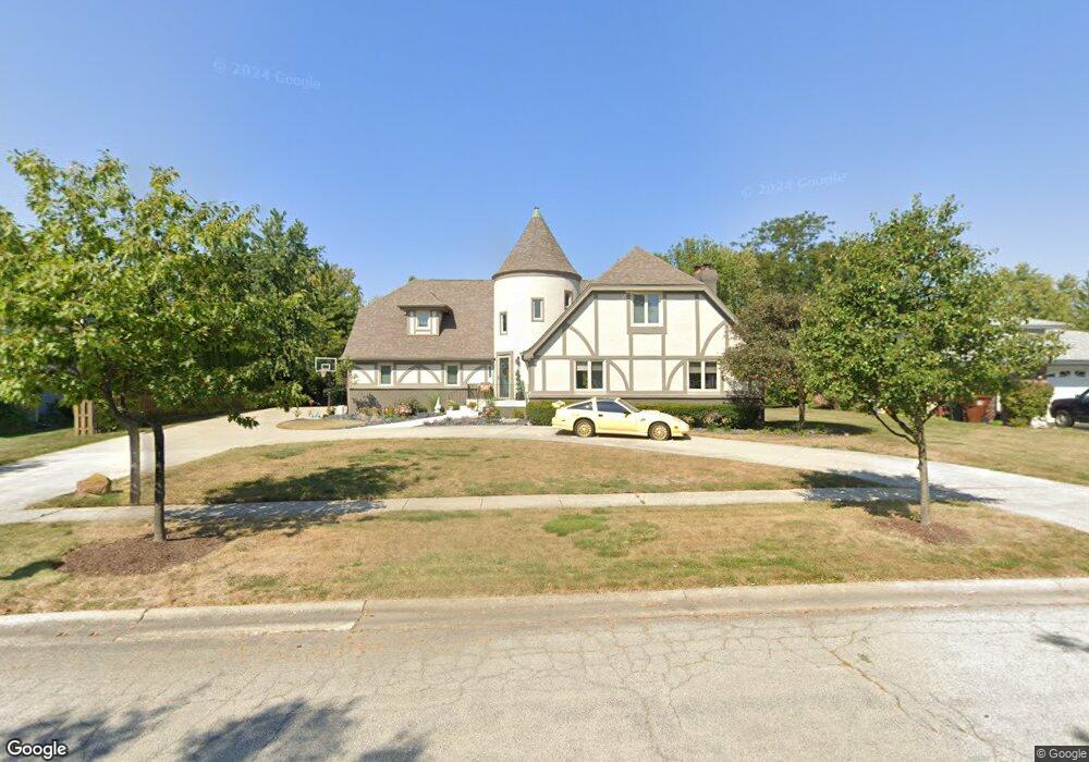
683 Brookside Ln Frankfort, IL 60423
North Frankfort NeighborhoodEstimated Value: $502,781 - $606,000
4
Beds
2
Baths
3,408
Sq Ft
$165/Sq Ft
Est. Value
About This Home
This home is located at 683 Brookside Ln, Frankfort, IL 60423 and is currently estimated at $562,945, approximately $165 per square foot. 683 Brookside Ln is a home located in Will County with nearby schools including Grand Prairie Elementary School, Chelsea Intermediate School, and Hickory Creek Middle School.
Ownership History
Date
Name
Owned For
Owner Type
Purchase Details
Closed on
Jul 25, 2000
Sold by
South Holland Trust & Svgs Bank
Bought by
Micetich Christopher J and Micetich Marilyn J
Current Estimated Value
Home Financials for this Owner
Home Financials are based on the most recent Mortgage that was taken out on this home.
Original Mortgage
$85,000
Interest Rate
8.19%
Create a Home Valuation Report for This Property
The Home Valuation Report is an in-depth analysis detailing your home's value as well as a comparison with similar homes in the area
Home Values in the Area
Average Home Value in this Area
Purchase History
| Date | Buyer | Sale Price | Title Company |
|---|---|---|---|
| Micetich Christopher J | $230,000 | First American Title |
Source: Public Records
Mortgage History
| Date | Status | Borrower | Loan Amount |
|---|---|---|---|
| Closed | Micetich Christopher J | $85,000 |
Source: Public Records
Tax History
| Year | Tax Paid | Tax Assessment Tax Assessment Total Assessment is a certain percentage of the fair market value that is determined by local assessors to be the total taxable value of land and additions on the property. | Land | Improvement |
|---|---|---|---|---|
| 2024 | $10,928 | $145,924 | $22,871 | $123,053 |
| 2023 | $10,928 | $130,324 | $20,426 | $109,898 |
| 2022 | $9,565 | $118,703 | $18,605 | $100,098 |
| 2021 | $9,016 | $111,052 | $17,406 | $93,646 |
| 2020 | $8,790 | $107,922 | $16,915 | $91,007 |
| 2019 | $8,506 | $105,033 | $16,462 | $88,571 |
| 2018 | $8,354 | $102,014 | $15,989 | $86,025 |
| 2017 | $8,347 | $99,633 | $15,616 | $84,017 |
| 2016 | $8,149 | $96,218 | $15,081 | $81,137 |
| 2015 | $7,834 | $92,830 | $14,550 | $78,280 |
| 2014 | $7,834 | $92,185 | $14,449 | $77,736 |
| 2013 | $7,834 | $93,380 | $14,636 | $78,744 |
Source: Public Records
Map
Nearby Homes
- 647 Johnson Ave
- 21629 Kent Ct
- 425 Cottonwood Rd
- 21726 Higley Ln
- 254 Willow St
- 558 Birchwood Rd
- 9736 Folkers Dr
- 725 Cedar Ln
- 9724 Folkers Dr
- 51 Kaffel Ct
- 719 Stonebridge Rd
- Lot 3 Town Center Dr
- 267 Center Rd
- 11140 Lincoln Hwy
- 10850 W Laraway Rd
- 21632 Wolf Rd
- 9815 W Laraway Rd
- 21213 S 93rd Ave
- 20659 Abbey Dr
- 11326 Wexford Dr
- 675 Brookside Ln
- 691 Brookside Ln
- 665 Brookside Ln
- 702 Franklin Ave
- 712 Franklin Ave
- 692 Franklin Ave
- 682 Brookside Ln
- 722 Franklin Ave
- 694 Brookside Ln
- 670 Brookside Ln
- 682 Franklin Ave
- 655 Brookside Ln
- 713 Brookside Ln
- 732 Franklin Ave
- 662 Franklin Ave
- 706 Brookside Ln
- 639 Brookside Ln
- 672 Franklin Ave
- 725 Brookside Ln
- 718 Brookside Ln
Your Personal Tour Guide
Ask me questions while you tour the home.