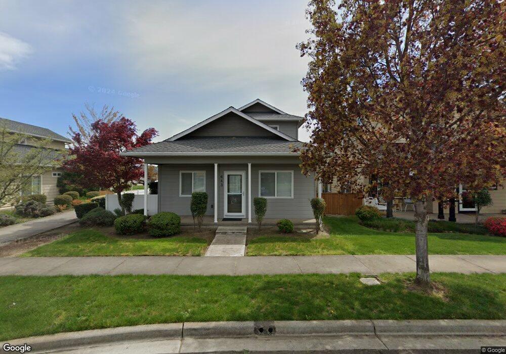
683 Buck Point St Central Point, OR 97502
Estimated Value: $399,238 - $487,000
3
Beds
3
Baths
1,676
Sq Ft
$268/Sq Ft
Est. Value
About This Home
This home is located at 683 Buck Point St, Central Point, OR 97502 and is currently estimated at $449,060, approximately $267 per square foot. 683 Buck Point St is a home located in Jackson County with nearby schools including Richardson Elementary School, Scenic Middle School, and Crater High School.
Ownership History
Date
Name
Owned For
Owner Type
Purchase Details
Closed on
Aug 17, 2010
Sold by
W L Moore Construction Inc
Bought by
Miller David G
Current Estimated Value
Home Financials for this Owner
Home Financials are based on the most recent Mortgage that was taken out on this home.
Original Mortgage
$197,910
Outstanding Balance
$130,705
Interest Rate
4.52%
Mortgage Type
New Conventional
Estimated Equity
$318,355
Create a Home Valuation Report for This Property
The Home Valuation Report is an in-depth analysis detailing your home's value as well as a comparison with similar homes in the area
Home Values in the Area
Average Home Value in this Area
Purchase History
| Date | Buyer | Sale Price | Title Company |
|---|---|---|---|
| Miller David G | $219,900 | Amerititle |
Source: Public Records
Mortgage History
| Date | Status | Borrower | Loan Amount |
|---|---|---|---|
| Open | Miller David G | $197,910 |
Source: Public Records
Tax History Compared to Growth
Tax History
| Year | Tax Paid | Tax Assessment Tax Assessment Total Assessment is a certain percentage of the fair market value that is determined by local assessors to be the total taxable value of land and additions on the property. | Land | Improvement |
|---|---|---|---|---|
| 2025 | $3,712 | $223,240 | $79,560 | $143,680 |
| 2024 | $3,712 | $216,740 | $77,240 | $139,500 |
| 2023 | $3,592 | $210,430 | $74,990 | $135,440 |
| 2022 | $3,508 | $210,430 | $74,990 | $135,440 |
| 2021 | $3,408 | $204,310 | $72,810 | $131,500 |
| 2020 | $3,309 | $198,360 | $70,690 | $127,670 |
| 2019 | $3,227 | $186,990 | $66,630 | $120,360 |
| 2018 | $3,129 | $181,550 | $64,690 | $116,860 |
| 2017 | $3,050 | $181,550 | $64,690 | $116,860 |
| 2016 | $2,961 | $171,140 | $60,980 | $110,160 |
| 2015 | $2,837 | $171,140 | $60,980 | $110,160 |
| 2014 | $2,765 | $161,330 | $57,470 | $103,860 |
Source: Public Records
Map
Nearby Homes
- 1159 Rustler Peak St
- 526 Stone Pointe Dr
- 1167 Boulder Ridge St
- 629 Bridge Creek Dr
- 1407 Rustler Peak St
- 1317 River Run St
- 0 Boulder Ridge St
- 426 Bridge Creek Dr
- 349 Cascade Dr
- 327 Brookhaven Dr
- 1135 Shake Dr
- 422 Castle Rock Dr
- 1134 Steamboat Dr
- 413 Sand Pointe Dr
- 356 Marian Ave Unit 40
- 4626 N Pacific Hwy
- 905 Comet Ave
- 626 Griffin Oaks Dr
- 335 Applewood Dr
- 407 Silver Creek Dr
- 691 Buck Point St
- 675 Buck Point St
- 699 Buck Point St
- 667 Buck Point St
- 659 Buck Point St
- 1174 Rustler Peak St
- 1166 Rustler Peak St
- 1158 Rustler Peak St
- 1150 Rustler Peak St
- 1142 Rustler Peak St
- 1163 N Haskell St
- 1171 N Haskell St
- 1134 Rustler Peak St
- 684 Grouse Ridge Dr
- 1155 N Haskell St
- 676 Grouse Ridge Dr
- 1147 N Haskell St
- 700 Grouse Ridge Dr
- 1139 N Haskell St
- 1126 Rustler Peak St