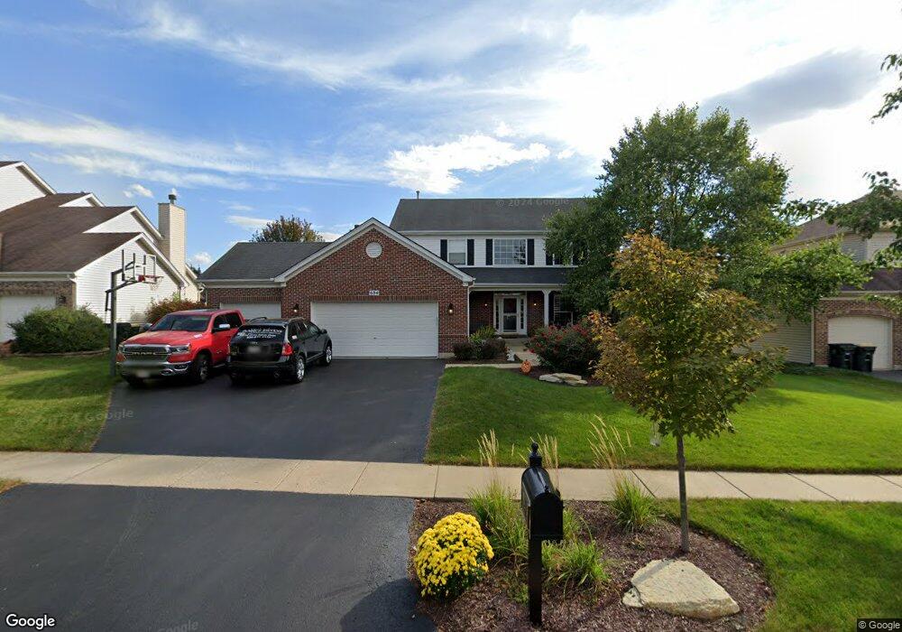
684 Manhattan Cir Oswego, IL 60543
Northwest Oswego NeighborhoodEstimated Value: $460,000 - $485,595
4
Beds
3
Baths
2,754
Sq Ft
$170/Sq Ft
Est. Value
About This Home
This home is located at 684 Manhattan Cir, Oswego, IL 60543 and is currently estimated at $467,649, approximately $169 per square foot. 684 Manhattan Cir is a home located in Kendall County with nearby schools including Fox Chase Elementary School, Traughber Junior High School, and Oswego High School.
Ownership History
Date
Name
Owned For
Owner Type
Purchase Details
Closed on
Aug 26, 2008
Sold by
Dolan Steven J and Dolan Melissa A
Bought by
Balder Douglas J and Balder Kimberli E
Current Estimated Value
Home Financials for this Owner
Home Financials are based on the most recent Mortgage that was taken out on this home.
Original Mortgage
$298,020
Interest Rate
5.09%
Mortgage Type
VA
Purchase Details
Closed on
Sep 14, 2005
Sold by
Richard Smykal Inc
Bought by
Dolan Steven J and Dolan Melissa A
Home Financials for this Owner
Home Financials are based on the most recent Mortgage that was taken out on this home.
Original Mortgage
$267,100
Interest Rate
6.01%
Mortgage Type
Fannie Mae Freddie Mac
Create a Home Valuation Report for This Property
The Home Valuation Report is an in-depth analysis detailing your home's value as well as a comparison with similar homes in the area
Home Values in the Area
Average Home Value in this Area
Purchase History
| Date | Buyer | Sale Price | Title Company |
|---|---|---|---|
| Balder Douglas J | $290,000 | Ticor Title Insurance Co | |
| Dolan Steven J | $334,000 | Chicago Title Insurance Co |
Source: Public Records
Mortgage History
| Date | Status | Borrower | Loan Amount |
|---|---|---|---|
| Previous Owner | Balder Douglas J | $298,020 | |
| Previous Owner | Dolan Steven J | $267,100 |
Source: Public Records
Tax History Compared to Growth
Tax History
| Year | Tax Paid | Tax Assessment Tax Assessment Total Assessment is a certain percentage of the fair market value that is determined by local assessors to be the total taxable value of land and additions on the property. | Land | Improvement |
|---|---|---|---|---|
| 2024 | $10,751 | $139,597 | $25,312 | $114,285 |
| 2023 | $10,234 | $123,537 | $22,400 | $101,137 |
| 2022 | $10,234 | $113,336 | $20,550 | $92,786 |
| 2021 | $9,323 | $108,977 | $19,760 | $89,217 |
| 2020 | $9,019 | $104,786 | $19,000 | $85,786 |
| 2019 | $8,846 | $101,487 | $19,000 | $82,487 |
| 2018 | $8,960 | $102,105 | $25,664 | $76,441 |
| 2017 | $8,646 | $90,341 | $23,545 | $66,796 |
| 2016 | $8,499 | $87,709 | $22,859 | $64,850 |
| 2015 | $8,372 | $82,744 | $21,565 | $61,179 |
| 2014 | -- | $78,060 | $20,344 | $57,716 |
| 2013 | -- | $78,848 | $20,549 | $58,299 |
Source: Public Records
Map
Nearby Homes
- 409 Fawn Dr
- 435 Fawn Dr
- 173 Dolores St
- 102 Mary St
- 238 Willowwood Dr
- 338 Millstream Ln Unit 1
- 602 Clearwater Ct Unit 2
- 411 Bayberry Dr
- 608 Clearwater Ct
- 2100 Light Rd Unit 109
- 514 Bentson St
- 1721 State Route 31
- 505 Parkland Ct
- 403 Lake Ct
- 125 Presidential Blvd Unit 3248
- 7.43 Acres Vacant La State Route 31
- 11-13 W Anchor Rd
- LOT 10 SW Station Dr
- 537 Arbor Ln
- 133 River Mist Dr Unit 3
- 686 Manhattan Cir
- 682 Manhattan Cir
- 415 Fawn Dr
- 417 Fawn Dr Unit 6
- 688 Manhattan Cir Unit 2
- 680 Manhattan Cir
- 413 Fawn Dr Unit 6
- 419 Fawn Dr
- 683 Manhattan Cir
- 685 Manhattan Cir
- 681 Manhattan Cir
- 411 Fawn Dr
- 690 Manhattan Cir Unit 2
- 678 Manhattan Cir
- 687 Manhattan Cir
- 679 Manhattan Cir
- 421 Fawn Dr
- 689 Manhattan Cir
- 692 Manhattan Cir Unit 2
- 414 Fawn Dr