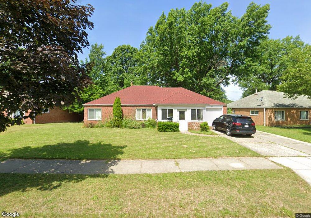
686 Walnut Dr Euclid, OH 44132
Estimated Value: $181,439 - $203,000
3
Beds
2
Baths
1,401
Sq Ft
$135/Sq Ft
Est. Value
About This Home
This home is located at 686 Walnut Dr, Euclid, OH 44132 and is currently estimated at $189,360, approximately $135 per square foot. 686 Walnut Dr is a home located in Cuyahoga County with nearby schools including Shoreview Elementary School, Euclid High School, and Mater Dei Academy.
Ownership History
Date
Name
Owned For
Owner Type
Purchase Details
Closed on
Sep 20, 2023
Sold by
Dennis H Kelsey H and Dennis Dorina A
Bought by
Kelsey Dennis H
Current Estimated Value
Purchase Details
Closed on
Jun 14, 2010
Sold by
Fannie Mae
Bought by
Kelsey Dennis H and Kelsey Dorina A
Home Financials for this Owner
Home Financials are based on the most recent Mortgage that was taken out on this home.
Original Mortgage
$58,500
Interest Rate
4.97%
Mortgage Type
New Conventional
Purchase Details
Closed on
Nov 30, 2009
Sold by
Gunter Willie L
Bought by
Federal National Mortgage Association
Purchase Details
Closed on
Jun 20, 2003
Sold by
Mcdonald Andre
Bought by
Gunter Willie L and Gunter Ursula A
Home Financials for this Owner
Home Financials are based on the most recent Mortgage that was taken out on this home.
Original Mortgage
$99,900
Interest Rate
5.4%
Mortgage Type
Purchase Money Mortgage
Purchase Details
Closed on
Oct 19, 2001
Sold by
Hud
Bought by
Mcdonald Andre
Home Financials for this Owner
Home Financials are based on the most recent Mortgage that was taken out on this home.
Original Mortgage
$58,500
Interest Rate
6.87%
Purchase Details
Closed on
Dec 19, 2000
Sold by
Abel Yvonne M
Bought by
Hud
Purchase Details
Closed on
Apr 4, 1996
Sold by
Quinn Coletta A
Bought by
Abel Yvonne M
Home Financials for this Owner
Home Financials are based on the most recent Mortgage that was taken out on this home.
Original Mortgage
$80,010
Interest Rate
7.36%
Mortgage Type
FHA
Purchase Details
Closed on
Sep 3, 1992
Sold by
Quinn Coletta A
Bought by
Quinn Coletta A
Purchase Details
Closed on
Oct 20, 1982
Sold by
Quinn Patrick J and C A
Bought by
Quinn Coletta A
Purchase Details
Closed on
Jan 1, 1975
Bought by
Quinn Patrick J and C A
Create a Home Valuation Report for This Property
The Home Valuation Report is an in-depth analysis detailing your home's value as well as a comparison with similar homes in the area
Home Values in the Area
Average Home Value in this Area
Purchase History
| Date | Buyer | Sale Price | Title Company |
|---|---|---|---|
| Kelsey Dennis H | -- | None Listed On Document | |
| Kelsey Dennis H | $65,000 | Barrister Title Agency | |
| Federal National Mortgage Association | $36,667 | Attorney | |
| Gunter Willie L | $99,900 | -- | |
| Mcdonald Andre | $78,800 | Gateway Title Agency Inc | |
| Hud | $70,000 | -- | |
| Abel Yvonne M | $80,000 | -- | |
| Quinn Coletta A | -- | -- | |
| Quinn Coletta A | -- | -- | |
| Quinn Patrick J | -- | -- |
Source: Public Records
Mortgage History
| Date | Status | Borrower | Loan Amount |
|---|---|---|---|
| Previous Owner | Kelsey Dennis H | $58,500 | |
| Previous Owner | Gunter Willie L | $99,900 | |
| Previous Owner | Mcdonald Andre | $58,500 | |
| Previous Owner | Abel Yvonne M | $80,010 |
Source: Public Records
Tax History
| Year | Tax Paid | Tax Assessment Tax Assessment Total Assessment is a certain percentage of the fair market value that is determined by local assessors to be the total taxable value of land and additions on the property. | Land | Improvement |
|---|---|---|---|---|
| 2024 | $3,365 | $58,555 | $10,395 | $48,160 |
| 2023 | $3,053 | $44,390 | $9,140 | $35,250 |
| 2022 | $3,017 | $44,380 | $9,140 | $35,250 |
| 2021 | $3,352 | $44,380 | $9,140 | $35,250 |
| 2020 | $2,610 | $33,640 | $6,930 | $26,710 |
| 2019 | $2,346 | $96,100 | $19,800 | $76,300 |
| 2018 | $2,122 | $33,640 | $6,930 | $26,710 |
| 2017 | $2,380 | $29,650 | $5,570 | $24,080 |
| 2016 | $2,385 | $26,400 | $5,570 | $20,830 |
| 2015 | $1,858 | $26,400 | $5,570 | $20,830 |
| 2014 | $1,858 | $26,400 | $5,570 | $20,830 |
Source: Public Records
Map
Nearby Homes
- 730 Hemlock Dr
- 670 Hemlock Dr
- 597 Hemlock Dr
- 591 Hemlock Dr
- 27190 Zeman Ave
- 815 E 272nd St
- 27125 Mallard Ave
- 26931 Shoreview Ave
- 27430 Forestview Ave
- 26831 Shoreview Ave
- 610 E 266th St
- 26430 Drakefield Ave
- 440 E 271st St
- 29310 Grand Blvd
- 1354 Craneing Rd
- 625 Lloyd Rd
- 26351 Farringdon Ave
- 643 E 261st St
- 427 E 275th St
- 27175 Cameron Ave
Your Personal Tour Guide
Ask me questions while you tour the home.