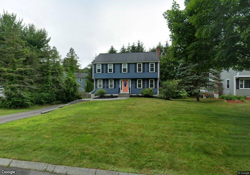
69 Tracy Cir Mansfield, MA 02048
Estimated Value: $709,379 - $873,000
4
Beds
3
Baths
1,800
Sq Ft
$434/Sq Ft
Est. Value
About This Home
This home is located at 69 Tracy Cir, Mansfield, MA 02048 and is currently estimated at $782,095, approximately $434 per square foot. 69 Tracy Cir is a home located in Bristol County with nearby schools including Jordan/Jackson Elementary School, Everett W. Robinson Elementary School, and Harold L. Qualters Middle School.
Ownership History
Date
Name
Owned For
Owner Type
Purchase Details
Closed on
Jun 24, 2003
Sold by
Kramer Michael Ross and Kramer Sara B
Bought by
Walsh Paul J and Walsh Ann Marie
Current Estimated Value
Home Financials for this Owner
Home Financials are based on the most recent Mortgage that was taken out on this home.
Original Mortgage
$280,000
Outstanding Balance
$122,030
Interest Rate
5.71%
Mortgage Type
Purchase Money Mortgage
Estimated Equity
$660,065
Purchase Details
Closed on
Jun 30, 1997
Sold by
Dionne Michael L and Dionne Lynn E
Bought by
Kramer Michael Ross and Kramer Sara B
Home Financials for this Owner
Home Financials are based on the most recent Mortgage that was taken out on this home.
Original Mortgage
$180,000
Interest Rate
7.81%
Mortgage Type
Purchase Money Mortgage
Purchase Details
Closed on
May 28, 1993
Sold by
East Coast Dev Ltd
Bought by
Dionne Michael L and Dionne Lynn E
Home Financials for this Owner
Home Financials are based on the most recent Mortgage that was taken out on this home.
Original Mortgage
$162,600
Interest Rate
7.41%
Mortgage Type
Purchase Money Mortgage
Create a Home Valuation Report for This Property
The Home Valuation Report is an in-depth analysis detailing your home's value as well as a comparison with similar homes in the area
Home Values in the Area
Average Home Value in this Area
Purchase History
| Date | Buyer | Sale Price | Title Company |
|---|---|---|---|
| Walsh Paul J | $399,500 | -- | |
| Kramer Michael Ross | $200,000 | -- | |
| Dionne Michael L | $171,250 | -- |
Source: Public Records
Mortgage History
| Date | Status | Borrower | Loan Amount |
|---|---|---|---|
| Open | Walsh Paul J | $280,000 | |
| Previous Owner | Dionne Michael L | $15,000 | |
| Previous Owner | Dionne Michael L | $180,000 | |
| Previous Owner | Dionne Michael L | $162,600 |
Source: Public Records
Tax History
| Year | Tax Paid | Tax Assessment Tax Assessment Total Assessment is a certain percentage of the fair market value that is determined by local assessors to be the total taxable value of land and additions on the property. | Land | Improvement |
|---|---|---|---|---|
| 2025 | $7,881 | $598,400 | $258,600 | $339,800 |
| 2024 | $7,718 | $571,700 | $269,900 | $301,800 |
| 2023 | $7,514 | $533,300 | $269,900 | $263,400 |
| 2022 | $7,238 | $477,100 | $249,800 | $227,300 |
| 2021 | $6,932 | $451,300 | $208,200 | $243,100 |
| 2020 | $6,832 | $444,800 | $208,200 | $236,600 |
| 2019 | $6,315 | $414,900 | $173,500 | $241,400 |
| 2018 | $6,265 | $402,400 | $165,400 | $237,000 |
| 2017 | $5,873 | $391,000 | $160,600 | $230,400 |
| 2016 | $5,637 | $365,800 | $152,900 | $212,900 |
| 2015 | $5,501 | $354,900 | $152,900 | $202,000 |
Source: Public Records
Map
Nearby Homes
- 571 Ware St
- 14 Windchime Dr
- 460 Ware St
- 1 Deer Path Ln
- 19 Barberry Rd
- 212 Mill St
- 21 Juniper Rd
- 44 Fairfield Park Unit 44
- 0 Kensington Rd
- 268 Reservoir St
- 0 Cobb St
- 0 Brook Pkwy
- 46 Hope St
- 28 Court St
- 250 Mansfield Ave Unit 11
- 6 Rumford Rd
- 10 Ridge Rd
- 266 N Main St Unit 3
- 81 Chilson Ave
- 1308-1310 East St
Your Personal Tour Guide
Ask me questions while you tour the home.