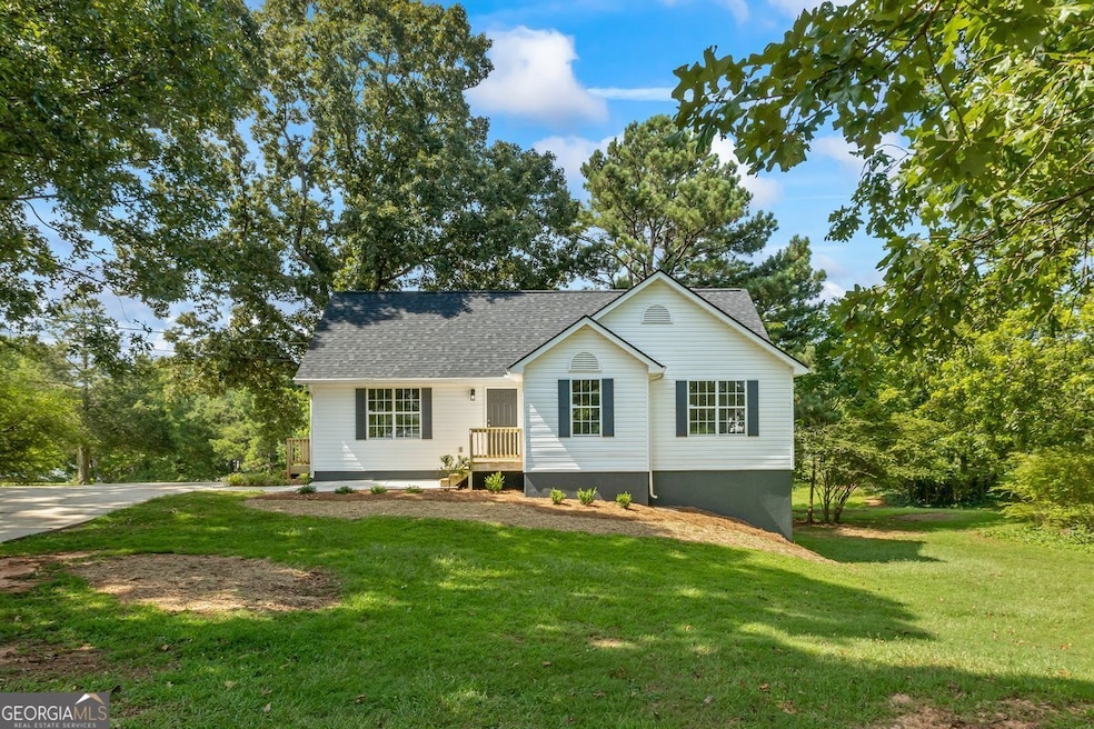
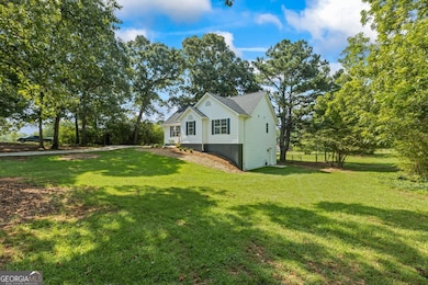
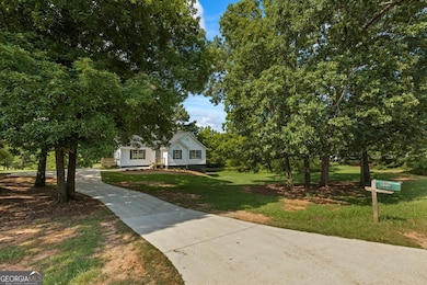
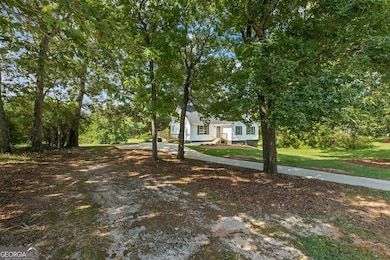

690 Laney Rd Locust Grove, GA 30248
Estimated payment $1,809/month
Highlights
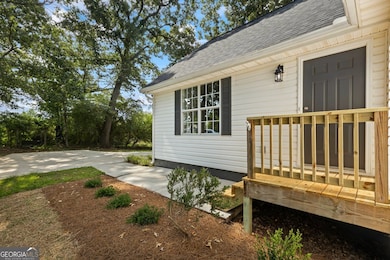
- Deck
- Vaulted Ceiling
- Main Floor Primary Bedroom
- Private Lot
- 2-Story Property
- Solid Surface Countertops
About This Home
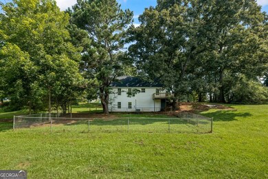
Welcome home to this newly RENOVATED property featuring 4 bedrooms, 3 full bathrooms, 2 bonus rooms and FINISHED BASEMENT on a PRIVATE 1 ACRE lot. You can enjoy your morning cup of coffee on the new back deck while connecting with nature. The home is great for entertaining friends and family with the large, private backyard and is ready to create many wonderful memories with the ones you love! With so many renovations, this home will also be stress-free and low maintenance for many years. RENOVATIONS include a NEW roof, NEW HVAC, NEW water heater, NEW interior paint, UPDATED kitchen with granite and stainless appliances, NEW flooring, NEW light fixtures, NEW plumbing fixtures, UPDATED bathrooms and a NEW back deck. Additional features include 2 additional finished rooms in the BASEMENT (perfect for a media room, office, etc..), plus a large unfinished storage room. Conveniently located just 10 minutes to Downtown McDonough & the Tanger Outlet mall in Locust Grove & only 45 minutes to Atlanta. Contact your Realtor to schedule your private showing before it's gone!
Home Details
Home Type
- Single Family
Est. Annual Taxes
- $1,254
Year Built
- Built in 1996 | Remodeled
Lot Details
- 1 Acre Lot
- Private Lot
Parking
- Parking Pad
Home Design
- 2-Story Property
- Composition Roof
- Vinyl Siding
Interior Spaces
- Vaulted Ceiling
- Double Pane Windows
- Family Room with Fireplace
- Laundry Room
Kitchen
- Breakfast Area or Nook
- Oven or Range
- Microwave
- Dishwasher
- Stainless Steel Appliances
- Solid Surface Countertops
Flooring
- Carpet
- Vinyl
Bedrooms and Bathrooms
- 4 Bedrooms | 3 Main Level Bedrooms
- Primary Bedroom on Main
- Walk-In Closet
- Soaking Tub
- Separate Shower
Finished Basement
- Basement Fills Entire Space Under The House
- Interior and Exterior Basement Entry
- Finished Basement Bathroom
- Natural lighting in basement
Outdoor Features
- Deck
- Porch
Schools
- New Hope Elementary School
- Locust Grove Middle School
- Locust Grove High School
Utilities
- Central Heating and Cooling System
- Septic Tank
- High Speed Internet
- Phone Available
- Cable TV Available
Community Details
- No Home Owners Association
Map
Home Values in the Area
Average Home Value in this Area
Tax History
| Year | Tax Paid | Tax Assessment Tax Assessment Total Assessment is a certain percentage of the fair market value that is determined by local assessors to be the total taxable value of land and additions on the property. | Land | Improvement |
|---|---|---|---|---|
| 2025 | $1,254 | $110,480 | $14,000 | $96,480 |
| 2024 | $1,254 | $110,400 | $14,000 | $96,400 |
| 2023 | $1,634 | $108,240 | $14,000 | $94,240 |
| 2022 | $1,784 | $94,680 | $14,000 | $80,680 |
| 2021 | $1,260 | $74,600 | $14,000 | $60,600 |
| 2020 | $944 | $62,320 | $12,000 | $50,320 |
| 2019 | $932 | $61,880 | $12,000 | $49,880 |
| 2018 | $739 | $54,360 | $10,800 | $43,560 |
| 2016 | $644 | $51,520 | $10,000 | $41,520 |
| 2015 | $529 | $43,800 | $8,000 | $35,800 |
| 2014 | $461 | $38,760 | $8,000 | $30,760 |
Property History
| Date | Event | Price | List to Sale | Price per Sq Ft |
|---|---|---|---|---|
| 12/04/2025 12/04/25 | Price Changed | $324,900 | -3.0% | $145 / Sq Ft |
| 11/13/2025 11/13/25 | For Sale | $334,900 | -- | $149 / Sq Ft |
Purchase History
| Date | Type | Sale Price | Title Company |
|---|---|---|---|
| Limited Warranty Deed | $160,000 | -- | |
| Deed | $130,000 | -- | |
| Deed | $88,700 | -- |
Mortgage History
| Date | Status | Loan Amount | Loan Type |
|---|---|---|---|
| Open | $252,000 | New Conventional | |
| Previous Owner | $123,500 | New Conventional |
Source: Georgia MLS
MLS Number: 10642860
APN: 157A-01-008-000
Disclaimer: Certain information contained herein is derived from information provided by parties other than Homes.com. All information provided is deemed reliable, but is not guaranteed to be accurate and should be independently verified.
![]() The data relating to real estate for sale on this web site comes in part from the Broker Reciprocity Program of Georgia MLS. Real estate listings held by brokerage firms other than Redfin are marked with the Broker Reciprocity logo and detailed information about them includes the name of the listing brokers. Information deemed reliable but not guaranteed. Copyright 2025 Georgia MLS. All rights reserved.
The data relating to real estate for sale on this web site comes in part from the Broker Reciprocity Program of Georgia MLS. Real estate listings held by brokerage firms other than Redfin are marked with the Broker Reciprocity logo and detailed information about them includes the name of the listing brokers. Information deemed reliable but not guaranteed. Copyright 2025 Georgia MLS. All rights reserved.
- 376 Cattlemans Cir
- S S Laney Rd
- 976 S Laney Rd
- 136 Ducati Dr
- 121 Ducati Dr
- 328 Cattlemans Cir
- 0 S Ola Rd Unit 10563258
- 125 Karen Dr
- 732 New Hope Rd
- 125 Laney Ct
- 175 Laney Ct Unit 1
- 215 Laney Rd
- 100 Harbin Trail
- 225 Laney Ct
- 290 New Hope Rd
- 1126 Old Jackson Rd
- 143 Whitworth Dr Unit 10
- 147 Whitworth Dr
- 150 Whitworth Dr
- 207 Michele Ct
- 480 Laney Rd
- 144 Ducati Dr
- 335 Cattlemans Cir
- 306 Laney Rd
- 144 Leguin Forest Dr
- 1800 Highway 81 E
- 145 Cardell Farms Rd
- 2236 Peeksville Rd
- 1004 Buttercup Ln
- 215 Winston Dr
- 1374 Lake Dow Rd
- 148 Oliver Dr
- 204 Oliver Dr
- 1205 Polk Crossing
- 129 Oliver Dr
- 3023 Ryan Rd
- 107 Sanders Walk
- 3219 Puritan Way
- 173 Everett Square
- 649 Gleaner Way
