Estimated Value: $356,000 - $419,000
4
Beds
2
Baths
1,900
Sq Ft
$199/Sq Ft
Est. Value
About This Home
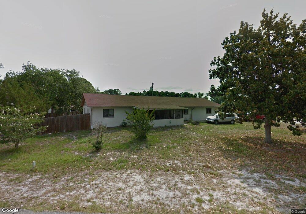
This home is located at 6909 Bryant Rd, Cocoa, FL 32927 and is currently estimated at $377,485, approximately $198 per square foot. 6909 Bryant Rd is a home located in Brevard County with nearby schools including Enterprise Elementary School, Space Coast Junior/Senior High School, and Sculptor Charter School.
Ownership History
Date
Name
Owned For
Owner Type
Purchase Details
Closed on
Feb 26, 2020
Sold by
Deutsche Bank Trust Company
Bought by
Kyro Michael and Kyro George
Current Estimated Value
Purchase Details
Closed on
Jan 29, 2007
Sold by
Glover Harry Thomas and Glover Vicki
Bought by
Otterbine Frank G and Otterbine Christine C
Home Financials for this Owner
Home Financials are based on the most recent Mortgage that was taken out on this home.
Original Mortgage
$162,400
Interest Rate
6.08%
Purchase Details
Closed on
Jan 24, 2007
Sold by
Glover Herry Thomas and Glover William Howard
Bought by
Otterbine Frank G and Otterbine Christine C
Home Financials for this Owner
Home Financials are based on the most recent Mortgage that was taken out on this home.
Original Mortgage
$162,400
Interest Rate
6.08%
Create a Home Valuation Report for This Property
The Home Valuation Report is an in-depth analysis detailing your home's value as well as a comparison with similar homes in the area
Home Values in the Area
Average Home Value in this Area
Purchase History
| Date | Buyer | Sale Price | Title Company |
|---|---|---|---|
| Kyro Michael | $151,000 | Premium Title Svcs Fl Inc | |
| Otterbine Frank G | -- | Fidelity Natl Title Ins Co | |
| Otterbine Frank G | $203,000 | Fidelity Natl Title Ins Co |
Source: Public Records
Mortgage History
| Date | Status | Borrower | Loan Amount |
|---|---|---|---|
| Previous Owner | Otterbine Frank G | $162,400 |
Source: Public Records
Tax History
| Year | Tax Paid | Tax Assessment Tax Assessment Total Assessment is a certain percentage of the fair market value that is determined by local assessors to be the total taxable value of land and additions on the property. | Land | Improvement |
|---|---|---|---|---|
| 2025 | $3,131 | $238,340 | -- | -- |
| 2024 | $3,085 | $231,630 | -- | -- |
| 2023 | $3,085 | $224,890 | $0 | $0 |
| 2022 | $2,893 | $218,340 | $0 | $0 |
| 2021 | $2,958 | $211,990 | $63,000 | $148,990 |
| 2020 | $3,176 | $189,930 | $60,000 | $129,930 |
| 2019 | $1,190 | $88,150 | $0 | $0 |
| 2018 | $1,180 | $86,510 | $0 | $0 |
| 2017 | $1,168 | $84,740 | $0 | $0 |
| 2016 | $1,167 | $83,000 | $36,000 | $47,000 |
| 2015 | $1,177 | $82,430 | $30,000 | $52,430 |
| 2014 | $1,177 | $81,780 | $22,000 | $59,780 |
Source: Public Records
Map
Nearby Homes
- 6815 Bryant Rd
- 7065 Hundred Acre Dr
- 6990 Bryant Rd
- 5155 Mayflower St
- 6760 Cairo Rd
- 5165 Patricia St
- 5555 Brandon St
- 5075 Carter St
- 5080 Mayflower St
- 7230 Venus Ave
- 6615 Dock Ave
- 5200 Frisco St
- 5680 Brandon St
- 7155 Export Ave
- 7200 Oakwood Ave
- 7045 Grissom Pkwy
- 5150 Melody St
- 7635 Fringe Place
- 6581 Bancroft Ave
- 6620 Grissom Pkwy
Your Personal Tour Guide
Ask me questions while you tour the home.