Estimated Value: $247,485 - $314,000
3
Beds
2
Baths
1,214
Sq Ft
$231/Sq Ft
Est. Value
About This Home
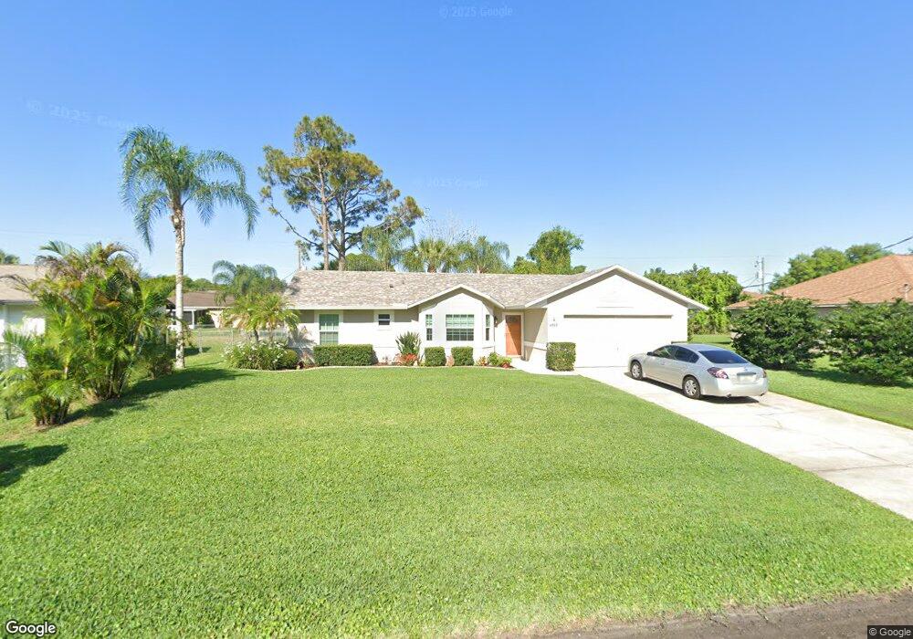
This home is located at 6950 Cairo Rd, Cocoa, FL 32927 and is currently estimated at $280,871, approximately $231 per square foot. 6950 Cairo Rd is a home located in Brevard County with nearby schools including Enterprise Elementary School, Space Coast Junior/Senior High School, and Sculptor Charter School.
Ownership History
Date
Name
Owned For
Owner Type
Purchase Details
Closed on
Jun 16, 1997
Sold by
Veterans Affairs
Bought by
Tribout Patricia R and Blackwell Maureen
Current Estimated Value
Home Financials for this Owner
Home Financials are based on the most recent Mortgage that was taken out on this home.
Original Mortgage
$67,775
Outstanding Balance
$9,657
Interest Rate
7.93%
Estimated Equity
$271,214
Purchase Details
Closed on
Aug 6, 1996
Sold by
Clerk Circuit Court
Bought by
Veterans Affairs
Create a Home Valuation Report for This Property
The Home Valuation Report is an in-depth analysis detailing your home's value as well as a comparison with similar homes in the area
Home Values in the Area
Average Home Value in this Area
Purchase History
| Date | Buyer | Sale Price | Title Company |
|---|---|---|---|
| Tribout Patricia R | $70,500 | -- | |
| Veterans Affairs | $1,000 | -- |
Source: Public Records
Mortgage History
| Date | Status | Borrower | Loan Amount |
|---|---|---|---|
| Open | Tribout Patricia R | $67,775 |
Source: Public Records
Tax History
| Year | Tax Paid | Tax Assessment Tax Assessment Total Assessment is a certain percentage of the fair market value that is determined by local assessors to be the total taxable value of land and additions on the property. | Land | Improvement |
|---|---|---|---|---|
| 2025 | $1,036 | $76,610 | -- | -- |
| 2024 | $1,016 | $74,460 | -- | -- |
| 2023 | $1,016 | $72,300 | $0 | $0 |
| 2022 | $958 | $70,200 | $0 | $0 |
| 2021 | $961 | $68,160 | $0 | $0 |
| 2020 | $915 | $67,220 | $0 | $0 |
| 2019 | $863 | $65,710 | $0 | $0 |
| 2018 | $864 | $64,490 | $0 | $0 |
| 2017 | $865 | $63,170 | $0 | $0 |
| 2016 | $872 | $61,880 | $18,000 | $43,880 |
| 2015 | $879 | $61,450 | $15,000 | $46,450 |
| 2014 | $884 | $60,970 | $11,000 | $49,970 |
Source: Public Records
Map
Nearby Homes
- 6990 Bryant Rd
- 7065 Hundred Acre Dr
- 5155 Mayflower St
- 6815 Bryant Rd
- 5165 Patricia St
- 6760 Cairo Rd
- 5075 Carter St
- 5555 Brandon St
- 5080 Mayflower St
- 7230 Venus Ave
- 5200 Frisco St
- 7155 Export Ave
- 6615 Dock Ave
- 7045 Grissom Pkwy
- 5150 Melody St
- 7200 Oakwood Ave
- 7635 Fringe Place
- 5680 Brandon St
- 7606 Fringe Place
- 6620 Grissom Pkwy
Your Personal Tour Guide
Ask me questions while you tour the home.