Estimated Value: $342,000 - $373,000
3
Beds
2
Baths
1,746
Sq Ft
$203/Sq Ft
Est. Value
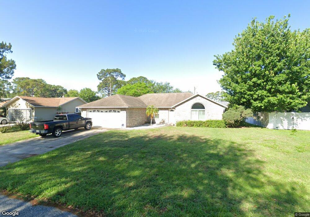
About This Home
This home is located at 6980 Bryant Rd, Cocoa, FL 32927 and is currently estimated at $354,746, approximately $203 per square foot. 6980 Bryant Rd is a home located in Brevard County with nearby schools including Enterprise Elementary School, Space Coast Junior/Senior High School, and Sculptor Charter School.
Ownership History
Date
Name
Owned For
Owner Type
Purchase Details
Closed on
Oct 11, 2002
Sold by
Lundy Gene R and Lundy Linda D
Bought by
Johnson Jeffrey W and Maitlen Laura J
Current Estimated Value
Home Financials for this Owner
Home Financials are based on the most recent Mortgage that was taken out on this home.
Original Mortgage
$54,000
Outstanding Balance
$22,722
Interest Rate
6.21%
Estimated Equity
$332,024
Purchase Details
Closed on
Dec 6, 1996
Sold by
Cohn Robert F and Cohn Jpatrica A
Bought by
Lundy Gene R and Lundy Linda D
Home Financials for this Owner
Home Financials are based on the most recent Mortgage that was taken out on this home.
Original Mortgage
$776
Interest Rate
7.77%
Create a Home Valuation Report for This Property
The Home Valuation Report is an in-depth analysis detailing your home's value as well as a comparison with similar homes in the area
Home Values in the Area
Average Home Value in this Area
Purchase History
| Date | Buyer | Sale Price | Title Company |
|---|---|---|---|
| Johnson Jeffrey W | $154,000 | -- | |
| Lundy Gene R | $110,900 | -- |
Source: Public Records
Mortgage History
| Date | Status | Borrower | Loan Amount |
|---|---|---|---|
| Open | Johnson Jeffrey W | $54,000 | |
| Previous Owner | Lundy Gene R | $776 |
Source: Public Records
Tax History
| Year | Tax Paid | Tax Assessment Tax Assessment Total Assessment is a certain percentage of the fair market value that is determined by local assessors to be the total taxable value of land and additions on the property. | Land | Improvement |
|---|---|---|---|---|
| 2025 | $1,587 | $117,180 | -- | -- |
| 2024 | $1,549 | $113,880 | -- | -- |
| 2023 | $1,549 | $110,570 | $0 | $0 |
| 2022 | $1,445 | $107,350 | $0 | $0 |
| 2021 | $874 | $104,230 | $0 | $0 |
| 2020 | $1,387 | $102,800 | $0 | $0 |
| 2019 | $1,324 | $100,490 | $0 | $0 |
| 2018 | $1,318 | $98,620 | $0 | $0 |
| 2017 | $1,314 | $96,600 | $0 | $0 |
| 2016 | $1,317 | $94,620 | $18,000 | $76,620 |
| 2015 | $920 | $93,970 | $15,000 | $78,970 |
| 2014 | $922 | $93,230 | $11,000 | $82,230 |
Source: Public Records
Map
Nearby Homes
- 6990 Bryant Rd
- 7065 Hundred Acre Dr
- 5165 Patricia St
- 5155 Mayflower St
- 5555 Brandon St
- 6815 Bryant Rd
- 7230 Venus Ave
- 6760 Cairo Rd
- 5080 Mayflower St
- 5075 Carter St
- 7200 Oakwood Ave
- 5200 Frisco St
- 7635 Fringe Place
- 5680 Brandon St
- 7606 Fringe Place
- 5150 Melody St
- 7155 Export Ave
- 6615 Dock Ave
- 7045 Grissom Pkwy
- 7419 Hackberry Rd
- 6970 Bryant Rd
- 6985 Kaylor Ave
- 6995 Kaylor Ave
- 7000 Bryant Rd
- 6960 Bryant Rd
- 6973 Bryant Rd
- 6997 Bryant Rd
- 7025 Kaylor Ave
- 6965 Bryant Rd
- 7020 Bryant Rd
- 6950 Bryant Rd
- 6965 Kaylor Ave
- 6957 Bryant Rd
- 7015 Bryant Rd
- 7010 Cairo Rd
- 7000 Cairo Rd
- 7045 Kaylor Ave
- 6990 Cairo Rd
- 6949 Bryant Rd
- 7040 Bryant Rd
Your Personal Tour Guide
Ask me questions while you tour the home.