


7 Brenton Ln Center Barnstead, NH 03225
Estimated payment $2,483/month
Highlights
- Community Beach Access
- Access To Lake
- Deck
- Golf Course Community
- Community Boat Launch
- Lake, Pond or Stream
About This Home
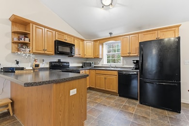
Now available in desirable Locke Lake Association, this one owner home is ready for you to make it your own! Conveniently located in the southern Lakes Region, just minutes from Route 28 for an easy commute. As a member of the Locke Lake Association, you’ll have access to private amenities including nine beaches on both Halfmoon and Locke Lakes, two in-ground pools, baseball field, tennis court, six-hole golf course, swing sets, covered pavilions, community lodge and two marinas. Built in 2010, this 3 bedroom/2 bathroom raised ranch is set up for one floor living. Open concept eat in kitchen and living room with cathedral ceilings. Direct access out to back deck and private back yard. Primary bedroom with private full bath, along with two other good sized bedrooms and bathroom with laundry. Spacious and insulated basement is ready for you to finish for additional space if desired. No need to shovel off your car this winter – this house has a direct entry two car garage. Whether you’re looking for a year-round residence or a peaceful vacation home, 7 Brenton Lane is located just steps from the North Shore Beach and boat ramp. Don’t miss out on this opportunity to embrace the lake lifestyle!
Listing Agent
NOBO Real Estate Brokerage Email: Jenn@noborealestate.com License #068022 Listed on: 11/07/2025
Home Details
Home Type
- Single Family
Est. Annual Taxes
- $5,224
Year Built
- Built in 2010
Lot Details
- 0.49 Acre Lot
- Property is zoned 208 LO
Parking
- 2 Car Direct Access Garage
- Automatic Garage Door Opener
- Driveway
Home Design
- Raised Ranch Architecture
- Wood Frame Construction
- Vinyl Siding
Interior Spaces
- Property has 1 Level
- Cathedral Ceiling
- Living Room
- Dining Area
Kitchen
- Microwave
- Dishwasher
Flooring
- Carpet
- Laminate
Bedrooms and Bathrooms
- 3 Bedrooms
- En-Suite Bathroom
Laundry
- Dryer
- Washer
Basement
- Walk-Out Basement
- Basement Fills Entire Space Under The House
Accessible Home Design
- Kitchen has a 60 inch turning radius
Outdoor Features
- Access To Lake
- Shared Private Water Access
- Water Access Across The Street
- Lake, Pond or Stream
- Deck
Schools
- Barnstead Elementary School
- Prospect Mountain High School
Utilities
- Baseboard Heating
- Hot Water Heating System
- Generator Hookup
- Septic Tank
- Phone Available
- Cable TV Available
Listing and Financial Details
- Tax Lot 412
- Assessor Parcel Number 42
Community Details
Overview
- Locke Lake Subdivision
Recreation
- Community Boat Launch
- Community Beach Access
- Golf Course Community
- Community Playground
Map
Home Values in the Area
Average Home Value in this Area
Tax History
| Year | Tax Paid | Tax Assessment Tax Assessment Total Assessment is a certain percentage of the fair market value that is determined by local assessors to be the total taxable value of land and additions on the property. | Land | Improvement |
|---|---|---|---|---|
| 2024 | $5,227 | $320,500 | $87,900 | $232,600 |
| 2023 | $4,599 | $320,500 | $87,900 | $232,600 |
| 2022 | $4,411 | $204,200 | $46,900 | $157,300 |
| 2021 | $4,484 | $204,200 | $46,900 | $157,300 |
| 2020 | $4,717 | $204,200 | $46,900 | $157,300 |
| 2019 | $4,662 | $204,200 | $46,900 | $157,300 |
| 2018 | $4,543 | $204,200 | $46,900 | $157,300 |
| 2017 | $4,384 | $151,700 | $30,600 | $121,100 |
| 2016 | $4,134 | $151,700 | $30,600 | $121,100 |
| 2015 | $4,119 | $151,700 | $30,600 | $121,100 |
| 2014 | $3,965 | $165,500 | $38,400 | $127,100 |
| 2013 | $3,889 | $165,500 | $38,400 | $127,100 |
Property History
| Date | Event | Price | List to Sale | Price per Sq Ft |
|---|---|---|---|---|
| 11/07/2025 11/07/25 | For Sale | $389,900 | -- | $316 / Sq Ft |
Purchase History
| Date | Type | Sale Price | Title Company |
|---|---|---|---|
| Deed | $179,500 | -- |
Mortgage History
| Date | Status | Loan Amount | Loan Type |
|---|---|---|---|
| Open | $183,153 | Purchase Money Mortgage |
Source: PrimeMLS
MLS Number: 5068921
APN: BRND-000042-000000-000412
Disclaimer: Certain information contained herein is derived from information provided by parties other than Homes.com. All information provided is deemed reliable, but is not guaranteed to be accurate and should be independently verified.
![]() Copyright 2025 PrimeMLS, Inc. All rights reserved. This information is deemed reliable, but not guaranteed. The data relating to real estate displayed on this display comes in part from the IDX Program of PrimeMLS. The information being provided is for consumers’ personal, non-commercial use and may not be used for any purpose other than to identify prospective properties consumers may be interested in purchasing.
Copyright 2025 PrimeMLS, Inc. All rights reserved. This information is deemed reliable, but not guaranteed. The data relating to real estate displayed on this display comes in part from the IDX Program of PrimeMLS. The information being provided is for consumers’ personal, non-commercial use and may not be used for any purpose other than to identify prospective properties consumers may be interested in purchasing.
- 248 Varney Rd
- O N Shore Dr
- 0 Corner North Shore Dr Unit 446 5054482
- 19 Nutter Cir
- 28 Dalton Dr
- 21 Shelburne Ln
- 956 N Barnstead Rd
- 96 Damsite Rd
- 0 Crescent Dr Unit 5026960
- 0 Andover Dr Unit 106 5059711
- 24 Danbury Rd
- 25 Vail Rd
- 17 Prospect Mountain Rd
- Lot 33 Ridge Rd
- 277 Shackford Corner Rd
- 109 Vail Rd
- 38 Chapelle Rd
- L68-2 Vail Rd
- L68-1 Vail Rd
- 117 Beaver Pond Dr
- 631 Prospect Mountain Rd Unit 2
- 5 Central St
- 11 Pearl Ln Unit 3
- 427 Silver St
- 438 Bow Lake Rd
- 1 Tristan Dr
- 4 Tristan Dr
- 12 Cornwall Place
- 55 Merlin Rd
- 7 Roberts Cove Rd Unit C
- 17 Basin Rd
- 118 Woodlands Rd
- 181 Mckeagney Rd
- 109 Bolan Rd
- 44 Mountain Dr
- 575 White Mountain Hwy
- 37 Pleasant Point Rd Unit B
- 6 Truman Cir
- 255 1st New Hampshire Turnpike Unit A through H
- 17 Norway Plains Rd
