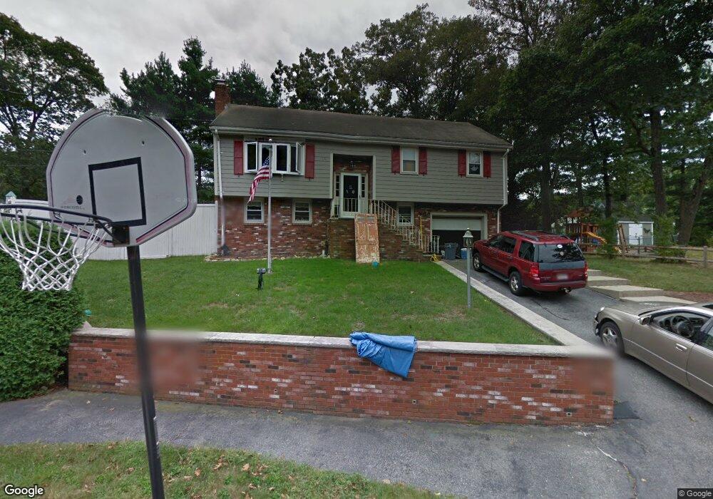
7 Stone Way Wakefield, MA 01880
Woodville NeighborhoodEstimated Value: $662,000 - $798,000
3
Beds
2
Baths
1,871
Sq Ft
$391/Sq Ft
Est. Value
About This Home
This home is located at 7 Stone Way, Wakefield, MA 01880 and is currently estimated at $732,419, approximately $391 per square foot. 7 Stone Way is a home located in Middlesex County with nearby schools including Wakefield Memorial High School, Pioneer Charter School Of Science II, and St Joseph School.
Ownership History
Date
Name
Owned For
Owner Type
Purchase Details
Closed on
Oct 15, 2012
Sold by
Ocallahan Brian
Bought by
Ocallahan Brian and Ocallahan Madeline
Current Estimated Value
Home Financials for this Owner
Home Financials are based on the most recent Mortgage that was taken out on this home.
Original Mortgage
$251,000
Outstanding Balance
$108,846
Interest Rate
3.59%
Mortgage Type
New Conventional
Estimated Equity
$623,574
Purchase Details
Closed on
Dec 27, 2002
Sold by
Kennedy Christine E and Kennedy Jon L
Bought by
Ocallahan Brian
Create a Home Valuation Report for This Property
The Home Valuation Report is an in-depth analysis detailing your home's value as well as a comparison with similar homes in the area
Home Values in the Area
Average Home Value in this Area
Purchase History
| Date | Buyer | Sale Price | Title Company |
|---|---|---|---|
| Ocallahan Brian | -- | -- | |
| Ocallahan Brian | -- | -- | |
| Ocallahan Brian | $420,000 | -- | |
| Ocallahan Brian | -- | -- | |
| Ocallahan Brian | $420,000 | -- |
Source: Public Records
Mortgage History
| Date | Status | Borrower | Loan Amount |
|---|---|---|---|
| Open | Ocallahan Brian | $251,000 | |
| Closed | Ocallahan Brian | $251,000 |
Source: Public Records
Tax History
| Year | Tax Paid | Tax Assessment Tax Assessment Total Assessment is a certain percentage of the fair market value that is determined by local assessors to be the total taxable value of land and additions on the property. | Land | Improvement |
|---|---|---|---|---|
| 2025 | $8,463 | $745,600 | $411,300 | $334,300 |
| 2024 | $8,142 | $723,700 | $399,200 | $324,500 |
| 2023 | $7,860 | $670,100 | $369,600 | $300,500 |
| 2022 | $7,508 | $609,400 | $336,000 | $273,400 |
| 2021 | $7,359 | $578,100 | $312,200 | $265,900 |
| 2020 | $7,078 | $554,300 | $299,300 | $255,000 |
| 2019 | $6,865 | $535,100 | $289,000 | $246,100 |
| 2018 | $6,496 | $501,600 | $270,900 | $230,700 |
| 2017 | $6,226 | $477,800 | $258,000 | $219,800 |
| 2016 | $5,863 | $434,600 | $238,500 | $196,100 |
| 2015 | $5,477 | $406,300 | $222,900 | $183,400 |
| 2014 | $5,031 | $393,700 | $216,000 | $177,700 |
Source: Public Records
Map
Nearby Homes
- 0 Everett St
- 34 Stark Ave
- 350 Water St
- 62 Golden Hills Rd
- 21 Herbert St Unit A
- 61 Nahant St
- 1 Sidney St
- 1 Traverse St Unit E
- 824 Main St Unit 1
- 35 Richardson St Unit 2
- 82 Water St
- 9 Cyrus St
- 24 Mount Zion Rd
- 176 Bay State Rd
- 24 Juniper Dr
- 7 West St
- 68 Preston St Unit 6D
- 10 Wakefield Ave Unit B
- 12 Heritage Ln
- 921 Sherwood Forest Ln
Your Personal Tour Guide
Ask me questions while you tour the home.