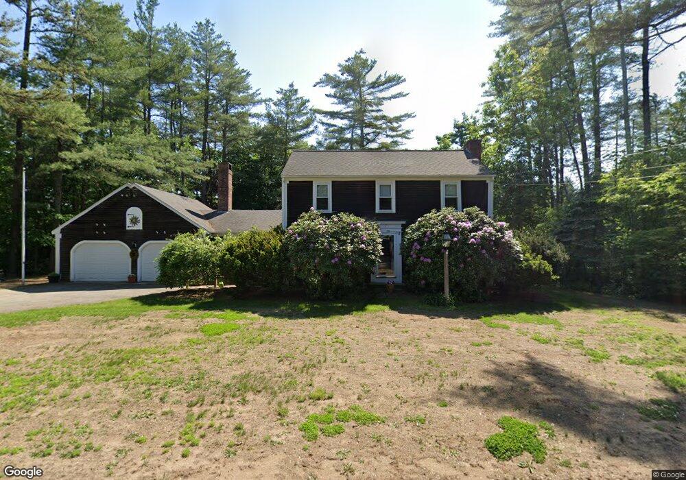
7 Susan Ln Rochester, NH 03867
Estimated Value: $466,539 - $494,000
4
Beds
2
Baths
1,948
Sq Ft
$248/Sq Ft
Est. Value
About This Home
This home is located at 7 Susan Ln, Rochester, NH 03867 and is currently estimated at $482,635, approximately $247 per square foot. 7 Susan Ln is a home located in Strafford County with nearby schools including William Allen School, Rochester Middle School, and Spaulding High School.
Ownership History
Date
Name
Owned For
Owner Type
Purchase Details
Closed on
Jul 29, 2005
Sold by
Jennings Margery M
Bought by
Gerrior Ln T
Current Estimated Value
Purchase Details
Closed on
May 19, 1999
Sold by
Rvk Florrie R Bergeron
Bought by
Webb Thomas C and Webb Lydia D
Home Financials for this Owner
Home Financials are based on the most recent Mortgage that was taken out on this home.
Original Mortgage
$58,000
Interest Rate
6.88%
Create a Home Valuation Report for This Property
The Home Valuation Report is an in-depth analysis detailing your home's value as well as a comparison with similar homes in the area
Home Values in the Area
Average Home Value in this Area
Purchase History
| Date | Buyer | Sale Price | Title Company |
|---|---|---|---|
| Gerrior Ln T | $85,000 | -- | |
| Webb Thomas C | $175,000 | -- |
Source: Public Records
Mortgage History
| Date | Status | Borrower | Loan Amount |
|---|---|---|---|
| Previous Owner | Webb Thomas C | $58,000 |
Source: Public Records
Tax History Compared to Growth
Tax History
| Year | Tax Paid | Tax Assessment Tax Assessment Total Assessment is a certain percentage of the fair market value that is determined by local assessors to be the total taxable value of land and additions on the property. | Land | Improvement |
|---|---|---|---|---|
| 2024 | $5,564 | $374,700 | $127,100 | $247,600 |
| 2023 | $5,815 | $225,900 | $63,200 | $162,700 |
| 2022 | $5,711 | $225,900 | $63,200 | $162,700 |
| 2021 | $5,568 | $225,900 | $63,200 | $162,700 |
| 2020 | $5,577 | $226,600 | $63,200 | $163,400 |
| 2019 | $5,642 | $226,600 | $63,200 | $163,400 |
| 2018 | $5,647 | $205,200 | $42,200 | $163,000 |
| 2017 | $5,403 | $205,200 | $42,200 | $163,000 |
| 2016 | $5,239 | $185,400 | $42,200 | $143,200 |
| 2015 | $5,219 | $185,400 | $42,200 | $143,200 |
| 2014 | $5,093 | $185,400 | $42,200 | $143,200 |
| 2013 | $5,688 | $215,800 | $56,200 | $159,600 |
| 2012 | $5,542 | $215,800 | $56,200 | $159,600 |
Source: Public Records
Map
Nearby Homes
- 9 Weeping Willow Dr
- 161 Lowell St
- 58 Pickering Rd
- 283 Chesley Hill Rd
- 8 Tebbetts Rd
- 3 Henrietta St
- 24 Birdie Grove Unit F
- 24 Birdie Grove Unit D
- 24 Birdie Grove Unit B
- 24 Birdie Grove Unit E
- 24 Birdie Grove Unit C
- 18 Birdie Grove Unit E
- 18 Birdie Grove Unit A
- 18 Birdie Grove Unit B
- 18 Birdie Grove Unit D
- 164 Brock St
- 13 Birdie Grove Unit C
- 13 Birdie Grove Unit D
- 144 Rochester Hill Rd
- 5 S Blueberry Ln