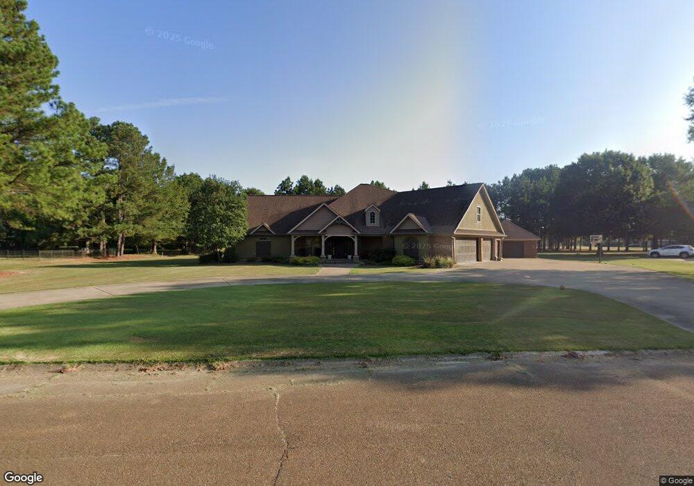
70 Broadmeadow Dr Grenada, MS 38901
Estimated Value: $467,086 - $729,000
4
Beds
3
Baths
3,899
Sq Ft
$146/Sq Ft
Est. Value
About This Home
This home is located at 70 Broadmeadow Dr, Grenada, MS 38901 and is currently estimated at $569,029, approximately $145 per square foot. 70 Broadmeadow Dr is a home with nearby schools including Grenada Elementary School, Grenada Upper Elementary School, and Grenada Middle School.
Ownership History
Date
Name
Owned For
Owner Type
Purchase Details
Closed on
Apr 29, 2021
Sold by
Vance Donald R and Vance Tammy M
Bought by
Moore Miles M and Moore Vanessa
Current Estimated Value
Home Financials for this Owner
Home Financials are based on the most recent Mortgage that was taken out on this home.
Original Mortgage
$362,415
Outstanding Balance
$325,631
Interest Rate
3.1%
Mortgage Type
Unknown
Estimated Equity
$243,398
Purchase Details
Closed on
Jun 2, 2010
Sold by
Phelon
Bought by
Vance
Create a Home Valuation Report for This Property
The Home Valuation Report is an in-depth analysis detailing your home's value as well as a comparison with similar homes in the area
Purchase History
| Date | Buyer | Sale Price | Title Company |
|---|---|---|---|
| Moore Miles M | -- | None Available | |
| Vance | $26,200 | -- |
Source: Public Records
Mortgage History
| Date | Status | Borrower | Loan Amount |
|---|---|---|---|
| Open | Moore Miles M | $362,415 |
Source: Public Records
Tax History
| Year | Tax Paid | Tax Assessment Tax Assessment Total Assessment is a certain percentage of the fair market value that is determined by local assessors to be the total taxable value of land and additions on the property. | Land | Improvement |
|---|---|---|---|---|
| 2025 | $3,479 | $42,616 | $3,000 | $39,616 |
| 2024 | $35 | $35,718 | $3,000 | $32,718 |
| 2023 | $3,514 | $35,718 | $3,000 | $32,718 |
| 2022 | $3,430 | $35,718 | $3,000 | $32,718 |
| 2021 | $2,536 | $32,867 | $3,000 | $29,867 |
| 2020 | $2,534 | $32,867 | $3,000 | $29,867 |
| 2019 | $2,539 | $32,924 | $3,000 | $29,924 |
| 2018 | $2,507 | $32,867 | $3,000 | $29,867 |
| 2017 | $2,948 | $32,867 | $3,000 | $29,867 |
| 2016 | $0 | $31,470 | $0 | $0 |
| 2015 | -- | $31,470 | $0 | $0 |
| 2014 | -- | $31,470 | $0 | $0 |
Source: Public Records
Map
Nearby Homes
- 865 John Borden Dr
- 1743 Perry Rd
- 31 Longview Dr
- 38 Longview Dr
- 2200 Perry Rd
- 2370 Perry Rd
- 1155 Highway 51 S
- 125 Railroad Dr
- 00 Halls Rd
- Tract 4 Tie Plant Rd
- 0 Nash Dr
- 856 Meadowbrook Rd
- 3788 Commerce St
- 2985 Carrollton Rd
- 2443 Laurin St
- 938 Sycamore St
- 1368 Joplin Dr
- 516 Chestnut St
- 2264 Long St
- 2221 Long St
- 60 Broadmeadow Dr
- 80 Broadmeadow Dr
- 110 Broadmeadow Dr
- 64 N Glen Brook Dr
- 85 Broadmeadow Dr
- 61 Broadmeadow Dr
- 94 N Glen Brook Dr
- 114 N Glen Brook Dr
- 34 N Glen Brook Dr
- 51 Broadmeadow Dr
- 14 N Glen Brook Dr
- 90 Broadmeadow Dr
- 111 Broadmeadow Dr
- 120 N Glen Brook Dr
- 18 S Glen Brook Dr
- 100 Broadmeadow Dr
- 55 N Glen Brook Dr
- 43 Brookwood Ct
- 55 Brookwood Ct
- 75 N Glen Brook Dr
Your Personal Tour Guide
Ask me questions while you tour the home.