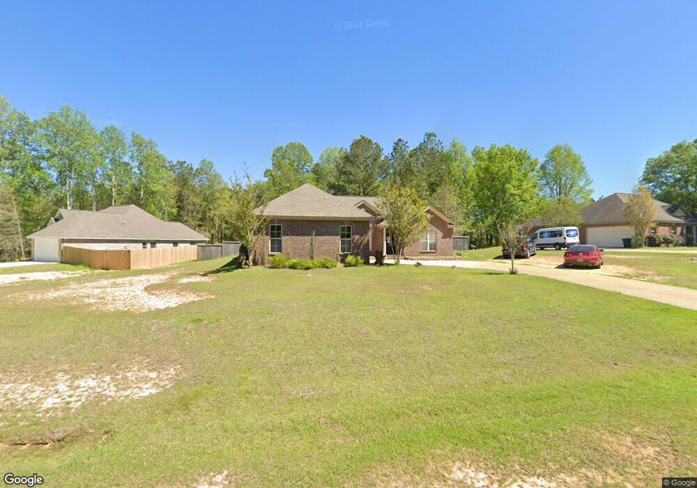
70 Latigo Loop Sumrall, MS 39482
Estimated Value: $256,506 - $312,000
3
Beds
3
Baths
1,972
Sq Ft
$144/Sq Ft
Est. Value
About This Home
This home is located at 70 Latigo Loop, Sumrall, MS 39482 and is currently estimated at $283,877, approximately $143 per square foot. 70 Latigo Loop is a home located in Lamar County with nearby schools including Sumrall Elementary School, Sumrall Middle School, and Sumrall High School.
Ownership History
Date
Name
Owned For
Owner Type
Purchase Details
Closed on
May 31, 2018
Sold by
Peterson Patrick C and Peterson Sara R
Bought by
Jones Troy Dwayne and Jones Laura Lynn
Current Estimated Value
Home Financials for this Owner
Home Financials are based on the most recent Mortgage that was taken out on this home.
Original Mortgage
$187,500
Outstanding Balance
$161,814
Interest Rate
4.5%
Mortgage Type
Purchase Money Mortgage
Estimated Equity
$122,063
Purchase Details
Closed on
Apr 12, 2013
Sold by
Smith Rocky Shane and Clinton Terry Shawn
Bought by
Peterson Patrick C and Peterson Sara R
Create a Home Valuation Report for This Property
The Home Valuation Report is an in-depth analysis detailing your home's value as well as a comparison with similar homes in the area
Purchase History
| Date | Buyer | Sale Price | Title Company |
|---|---|---|---|
| Jones Troy Dwayne | -- | -- | |
| Peterson Patrick C | -- | -- |
Source: Public Records
Mortgage History
| Date | Status | Borrower | Loan Amount |
|---|---|---|---|
| Open | Jones Troy Dwayne | $187,500 |
Source: Public Records
Tax History
| Year | Tax Paid | Tax Assessment Tax Assessment Total Assessment is a certain percentage of the fair market value that is determined by local assessors to be the total taxable value of land and additions on the property. | Land | Improvement |
|---|---|---|---|---|
| 2025 | $2,680 | $17,384 | $0 | $0 |
| 2024 | $2,680 | $17,384 | $0 | $0 |
| 2023 | $2,680 | $17,384 | $0 | $0 |
| 2022 | $1,926 | $14,436 | $0 | $0 |
| 2021 | $1,903 | $14,436 | $0 | $0 |
| 2020 | $1,903 | $14,436 | $0 | $0 |
| 2019 | $1,903 | $14,436 | $0 | $0 |
| 2018 | $3,252 | $21,308 | $0 | $0 |
| 2017 | $1,887 | $14,329 | $0 | $0 |
| 2015 | $1,930 | $14,613 | $0 | $0 |
| 2014 | $1,933 | $14,627 | $0 | $0 |
| 2013 | -- | $13,821 | $0 | $0 |
Source: Public Records
Map
Nearby Homes
- 150 Latigo Loop
- 171 Latigo Loop
- 4519 Highway 589
- 4519 Mississippi 589
- 9 Sanctuary Ln
- 1562 Oloh Rd
- 76 Meadow Breeze Dr
- 25 A Broome Rd
- 0 Mississippi 589
- 4837 Mississippi 589
- 4837 Highway 589
- 000 Rocky Branch Rd
- 00 Center Ave
- 95.3 ac Rocky Branch Rd
- 59 Hemingway Dr
- 0000 Mississippi 42
- 322 Mississippi 42
- 00 Mississippi 42
- 4264 Mississippi 589
- 962 Highway 42
- Lot 97 Latigo Loop
- 66 Latigo Loop
- 35 Fall Branch
- 62 Latigo Loop
- 100 Latigo Loop
- 33 Fall Branch
- 65 Latigo Loop
- 54 Latigo Loop
- 29 Fall Branch
- 59 Latigo Loop
- 32 Fall Branch
- 53 Latigo Loop
- 25 Fall Branch
- 50 Latigo Loop
- 28 Fall Branch
- Lot 52 Latigo Loop
- 132 Latigo Loop
- 128 Latigo Loop
- 80 Latigo Loop
- 52 Latigo Loop
Your Personal Tour Guide
Ask me questions while you tour the home.