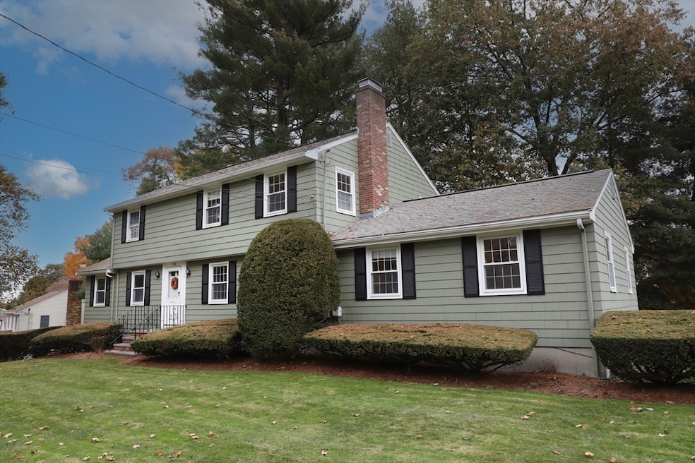
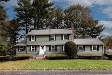
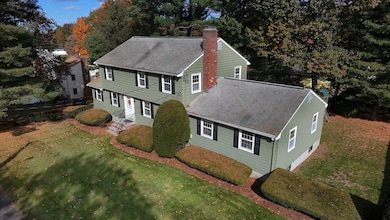
70 Old Nahant Rd Wakefield, MA 01880
Woodville NeighborhoodEstimated payment $5,833/month
Highlights
- Medical Services
- Property is near public transit
- Dutch Colonial Architecture
- Open Floorplan
- Wooded Lot
- Wood Flooring
About This Home
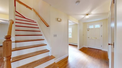
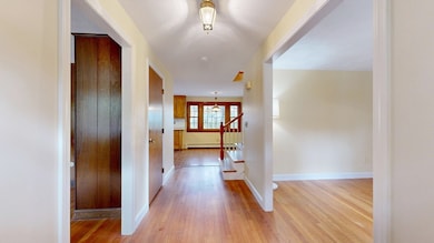
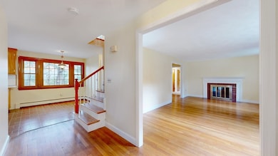
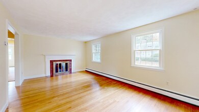
Welcome to 70 Old Nahant Rd- a rare 6 bedroom, beautifully maintained Dutch colonial tucked away in one of Wakefield’s most desirable neighborhoods! Appointed on an expansive lot, this exceptional home blends classic New England charm with modern convenience. An impressive & functional layout featuring sun-filled living spaces, HW floors throughout & an easy floorplan. The spacious kitchen, elegant dining room, formal living room w/fireplace, & cozy family room provide plenty of space for entertaining. The 1st floor features 2 spacious bedrooms, 1.5 baths, tranquil sunroom & grand staircase. The 2nd level boasts 4 bedrooms & a well-appointed full bath. This stunning property also includes ample storage, attached 2 car garage & 2 lower-level bonus rooms that can serve as a playroom, home office or gym. Mature landscaping frames a lush, private yard. Close proximity to Wakefield's vibrant downtown, public transport, highways & top schools. Timeless sophistication & effortless elegance.

Home Details
Home Type
- Single Family
Est. Annual Taxes
- $9,802
Year Built
- Built in 1967
Lot Details
- 0.28 Acre Lot
- Fenced Yard
- Gentle Sloping Lot
- Sprinkler System
- Wooded Lot
- Property is zoned SR
Parking
- 2 Car Attached Garage
- Tuck Under Parking
- Parking Storage or Cabinetry
- Garage Door Opener
- Driveway
- Open Parking
- Off-Street Parking
Home Design
- Dutch Colonial Architecture
- Frame Construction
- Shingle Roof
- Concrete Perimeter Foundation
Interior Spaces
- 2,636 Sq Ft Home
- Open Floorplan
- Chair Railings
- Light Fixtures
- Insulated Windows
- Insulated Doors
- Living Room with Fireplace
- Dining Area
- Bonus Room
- Sun or Florida Room
Kitchen
- Oven
- Range with Range Hood
- Microwave
- Freezer
- Dishwasher
- Disposal
Flooring
- Wood
- Wall to Wall Carpet
- Laminate
- Concrete
Bedrooms and Bathrooms
- 6 Bedrooms
- Primary bedroom located on second floor
- Dual Closets
- Bathtub with Shower
Laundry
- Dryer
- Washer
Partially Finished Basement
- Basement Fills Entire Space Under The House
- Interior Basement Entry
- Laundry in Basement
Home Security
- Storm Windows
- Storm Doors
Location
- Property is near public transit
- Property is near schools
Schools
- Woodville Elementary School
- Gavin Middle School
- Whs/Northeast Vocational Tech High School
Utilities
- Central Air
- 1 Cooling Zone
- 4 Heating Zones
- Heating System Uses Oil
- Baseboard Heating
- 220 Volts
- Water Heater
- Internet Available
Additional Features
- Energy-Efficient Thermostat
- Rain Gutters
Listing and Financial Details
- Assessor Parcel Number M:00040B B:0016 P:0000C8,823897
Community Details
Overview
- No Home Owners Association
- Woodville Subdivision
Amenities
- Medical Services
- Shops
- Coin Laundry
Recreation
- Park
- Jogging Path
- Bike Trail
Map
Home Values in the Area
Average Home Value in this Area
Tax History
| Year | Tax Paid | Tax Assessment Tax Assessment Total Assessment is a certain percentage of the fair market value that is determined by local assessors to be the total taxable value of land and additions on the property. | Land | Improvement |
|---|---|---|---|---|
| 2025 | $9,802 | $863,600 | $400,200 | $463,400 |
| 2024 | $9,258 | $822,900 | $381,300 | $441,600 |
| 2023 | $9,278 | $791,000 | $366,500 | $424,500 |
| 2022 | $8,941 | $725,700 | $336,300 | $389,400 |
| 2021 | $8,406 | $660,300 | $290,700 | $369,600 |
| 2020 | $8,014 | $627,600 | $276,300 | $351,300 |
| 2019 | $7,772 | $605,800 | $266,700 | $339,100 |
| 2018 | $7,492 | $578,500 | $254,700 | $323,800 |
| 2017 | $7,112 | $545,800 | $240,300 | $305,500 |
| 2016 | $6,383 | $473,200 | $212,500 | $260,700 |
| 2015 | $6,256 | $464,100 | $208,400 | $255,700 |
| 2014 | $5,815 | $455,000 | $204,300 | $250,700 |
Property History
| Date | Event | Price | List to Sale | Price per Sq Ft |
|---|---|---|---|---|
| 11/20/2025 11/20/25 | For Sale | $949,900 | -- | $360 / Sq Ft |
Purchase History
| Date | Type | Sale Price | Title Company |
|---|---|---|---|
| Deed | -- | -- |
Source: MLS Property Information Network (MLS PIN)
MLS Number: 73456834
APN: WAKE-000040B-000016-000000-C000008
Disclaimer: Certain information contained herein is derived from information provided by parties other than Homes.com. All information provided is deemed reliable, but is not guaranteed to be accurate and should be independently verified.
![]() The property listing data and information, or the Images, set forth herein were provided to MLS Property Information Network, Inc. from third party sources, including sellers, lessors and public records, and were compiled by MLS Property Information Network, Inc. The property listing data and information, and the Images, are for the personal, non-commercial use of consumers having a good faith interest in purchasing or leasing listed properties of the type displayed to them and may not be used for any purpose other than to identify prospective properties which such consumers may have a good faith interest in purchasing or leasing. MLS Property Information Network, Inc. and its subscribers disclaim any and all representations and warranties as to the accuracy of the property listing data and information, or as to the accuracy of any of the Images, set forth herein.
The property listing data and information, or the Images, set forth herein were provided to MLS Property Information Network, Inc. from third party sources, including sellers, lessors and public records, and were compiled by MLS Property Information Network, Inc. The property listing data and information, and the Images, are for the personal, non-commercial use of consumers having a good faith interest in purchasing or leasing listed properties of the type displayed to them and may not be used for any purpose other than to identify prospective properties which such consumers may have a good faith interest in purchasing or leasing. MLS Property Information Network, Inc. and its subscribers disclaim any and all representations and warranties as to the accuracy of the property listing data and information, or as to the accuracy of any of the Images, set forth herein.
- 6 Castle Clare Cir
- 8 Everett St
- 9 Lilah Cir
- 199 Nahant St
- 95 Greenwood Ave
- 18 Crosby Rd
- 6 Salisbury Rd
- 14 Sycamore Rd
- 1 Millbrook Ln Unit 111
- 1 Millbrook Ln Unit 304
- 24 Stark Ave
- 134 Nahant St Unit B
- 1 Sidney St
- 5 Bateman Ct Unit 5
- 15 Shore Rd
- 772 Main St Unit 2
- 974 Main St Unit 30
- 314 Water St Unit 5
- 18 Franklin St
- 38 Bennett St Unit 3D
- 15 Sycamore Rd
- 52 Valley St
- 5 Charles St Unit 1
- 1077 Main St
- 26 Atwood Ave Unit A
- 259 Water St Unit 101
- 12 Melrose Terrace Unit 13
- 12 Melrose Terrace Unit 5
- 12 Melrose Terrace
- 2 Melvin St Unit 2
- 2 Blue Jay Cir Unit 1
- 10 Wakefield Ave
- 10 Wakefield Ave
- 10 Wakefield Ave
- 10 Wakefield Ave
- 554 Main St Unit 2
- 27-37 Water St
- 43 Crescent St Unit 43
- 69 Foundry St Unit 416
- 62 Foundry St Unit 506