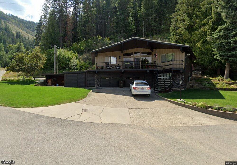
701 E Fir Ave Osburn, ID 83849
Estimated Value: $315,340 - $406,000
4
Beds
2
Baths
2,297
Sq Ft
$158/Sq Ft
Est. Value
About This Home
This home is located at 701 E Fir Ave, Osburn, ID 83849 and is currently estimated at $361,835, approximately $157 per square foot. 701 E Fir Ave is a home with nearby schools including Silver Hills Elementary School and Wallace Junior/Senior High School.
Ownership History
Date
Name
Owned For
Owner Type
Purchase Details
Closed on
Jul 26, 2018
Sold by
Jennifer Davin C
Bought by
Jennifer Davin C and Jennifer Stephine D
Current Estimated Value
Purchase Details
Closed on
Apr 25, 2008
Sold by
Jennings Renee
Bought by
Jennings Davin C
Home Financials for this Owner
Home Financials are based on the most recent Mortgage that was taken out on this home.
Original Mortgage
$179,655
Outstanding Balance
$112,851
Interest Rate
5.81%
Estimated Equity
$248,984
Purchase Details
Closed on
Oct 3, 2006
Sold by
Jennings Davin C and Jennings Renee
Bought by
Jennings Davin C and Jennings Renee
Purchase Details
Closed on
May 26, 2005
Sold by
Jennings Davin C
Bought by
Jennings Davin C and Pommerening Renee
Home Financials for this Owner
Home Financials are based on the most recent Mortgage that was taken out on this home.
Original Mortgage
$116,000
Interest Rate
5.84%
Create a Home Valuation Report for This Property
The Home Valuation Report is an in-depth analysis detailing your home's value as well as a comparison with similar homes in the area
Home Values in the Area
Average Home Value in this Area
Purchase History
| Date | Buyer | Sale Price | Title Company |
|---|---|---|---|
| Jennifer Davin C | -- | None Available | |
| Jennings Davin C | -- | -- | |
| Jennings Davin C | -- | -- | |
| Jennings Davin C | -- | -- |
Source: Public Records
Mortgage History
| Date | Status | Borrower | Loan Amount |
|---|---|---|---|
| Open | Jennings Davin C | $179,655 | |
| Previous Owner | Jennings Davin C | $116,000 |
Source: Public Records
Tax History Compared to Growth
Tax History
| Year | Tax Paid | Tax Assessment Tax Assessment Total Assessment is a certain percentage of the fair market value that is determined by local assessors to be the total taxable value of land and additions on the property. | Land | Improvement |
|---|---|---|---|---|
| 2025 | $1,827 | $351,808 | $47,753 | $304,055 |
| 2024 | $1,827 | $351,808 | $47,753 | $304,055 |
| 2023 | $1,827 | $355,619 | $47,753 | $307,866 |
| 2022 | $2,478 | $341,410 | $43,193 | $298,217 |
| 2021 | $2,400 | $266,778 | $36,855 | $229,923 |
| 2020 | $1,929 | $199,031 | $32,891 | $166,140 |
| 2019 | $4,151 | $211,476 | $30,310 | $181,166 |
| 2018 | $3,441 | $147,304 | $27,555 | $119,749 |
| 2017 | $3,347 | $147,315 | $27,555 | $119,760 |
| 2016 | $3,195 | $134,353 | $27,555 | $106,798 |
| 2015 | -- | $134,353 | $27,555 | $106,798 |
| 2014 | -- | $134,352 | $27,554 | $106,798 |
Source: Public Records
Map
Nearby Homes
- 1154 E Larch Ave
- 807 E Garden Ave
- 511 E Idaho Ave
- 67 Nuchols Gulch Rd
- 313 E Larch Ave
- 315 W Yellowstone Ave
- 905 Terror Gulch Rd
- 0 Cameron Dr Unit 25-1685
- 712 W Yellowstone Ave
- 120 4th St
- 235 Rio Vista St
- 225 Rio Vista St
- 104 Ninth St
- Lot 2B Upper Dr
- 99 Sather Field Rd
- 498 Revenue Gulch Rd
- 117 River St
- 3 Polaris Peak Rd
- 1 Polaris Peak Rd
- 2 Polaris Peak Rd
- 237 W Chestnut Ave
- 1822 W Polaris Ave
- 724 E Chestnut Ave
- 221 E Mullan Ave
- 415 E Walnut Ave
- 55371 Silver Valley Rd
- 204 W Chestnut Ave
- 510 W Polaris Ave
- 910 W Polaris Ave
- 55393 Silver Valley Rd
- 55501 Silver Valley Rd
- 610 W Yellowstone Ave
- 1217 E Fir Ave
- 408 E Walnut Ave
- 55409 Silver Valley Rd
- 208 W Chestnut Ave
- 216 W Chestnut Ave
- 1363 E Mullan Ave
- 218 W Chestnut Ave
- 1355 E Mullan Ave