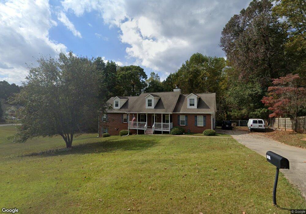
701 Erin Dr Stockbridge, GA 30281
Estimated Value: $367,155 - $415,000
6
Beds
3
Baths
3,075
Sq Ft
$128/Sq Ft
Est. Value
About This Home
This home is located at 701 Erin Dr, Stockbridge, GA 30281 and is currently estimated at $393,539, approximately $127 per square foot. 701 Erin Dr is a home located in Henry County with nearby schools including Woodland Elementary School, Woodland Middle School, and Woodland High School.
Ownership History
Date
Name
Owned For
Owner Type
Purchase Details
Closed on
Nov 22, 2024
Sold by
Page Debra J
Bought by
Page Debra J and Page Wayne Allen
Current Estimated Value
Purchase Details
Closed on
Sep 24, 1997
Sold by
Peachtree Homes Inc
Bought by
Page Sarah P and Page Randall P
Home Financials for this Owner
Home Financials are based on the most recent Mortgage that was taken out on this home.
Original Mortgage
$100,000
Interest Rate
7.55%
Mortgage Type
New Conventional
Create a Home Valuation Report for This Property
The Home Valuation Report is an in-depth analysis detailing your home's value as well as a comparison with similar homes in the area
Home Values in the Area
Average Home Value in this Area
Purchase History
| Date | Buyer | Sale Price | Title Company |
|---|---|---|---|
| Page Debra J | -- | -- | |
| Page Debra J | -- | -- | |
| Page Sarah P | $151,000 | -- |
Source: Public Records
Mortgage History
| Date | Status | Borrower | Loan Amount |
|---|---|---|---|
| Previous Owner | Page Sarah P | $100,000 |
Source: Public Records
Tax History Compared to Growth
Tax History
| Year | Tax Paid | Tax Assessment Tax Assessment Total Assessment is a certain percentage of the fair market value that is determined by local assessors to be the total taxable value of land and additions on the property. | Land | Improvement |
|---|---|---|---|---|
| 2025 | $1,925 | $159,036 | $18,000 | $141,036 |
| 2024 | $1,925 | $151,440 | $18,000 | $133,440 |
| 2023 | $2,791 | $151,320 | $16,000 | $135,320 |
| 2022 | $4,664 | $119,880 | $12,000 | $107,880 |
| 2021 | $3,924 | $100,600 | $12,000 | $88,600 |
| 2020 | $3,726 | $95,440 | $10,800 | $84,640 |
| 2019 | $3,579 | $91,600 | $10,800 | $80,800 |
| 2018 | $3,335 | $85,240 | $10,000 | $75,240 |
| 2016 | $2,741 | $69,760 | $10,000 | $59,760 |
| 2015 | $2,524 | $62,160 | $7,200 | $54,960 |
| 2014 | $2,417 | $58,760 | $7,200 | $51,560 |
Source: Public Records
Map
Nearby Homes
- 0 Mckenzie Ave Unit 10593345
- 564 Mckenzie Ave
- 805 Anna Kathryn Dr
- 825 Anna Kathryn Dr
- 809 Anna Kathryn Dr
- 807 Anna Kathryn Dr
- 829 Anna Kathryn Dr
- 830 Anna Kathryn Dr
- 811 Anna Kathryn Dr
- 831 Anna Kathryn Dr
- 813 Anna Kathryn Dr
- 719 Erin Dr
- 608 Mckenzie Cir
- 320 Mckenzie Dr
- 551 Hood Rd
- 95 Fern Ct
- 65 Wynfield Dr
- 164 Mckenzie Ct
- 120 Montgomery Dr
- 104 Montgomery Dr
- 542 Mckenzie Ave
- 703 Erin Dr
- 533 Mckenzie Ave
- 540 Mckenzie Ave
- 544 Mckenzie Ave
- 705 Erin Dr
- 1219 Sheelagh Ct
- 531 Mckenzie Ave
- 538 Mckenzie Ave
- 546 Mckenzie Ave
- 707 Erin Dr
- 704 Erin Dr
- 535 Mckenzie Ave
- 537 Mckenzie Ave
- 543 Mckenzie Ave
- 548 Mckenzie Ave
- 529 Mckenzie Ave
- 684 Mckenzie Cir
- 536 Mckenzie Ave
- 545 Mckenzie Ave