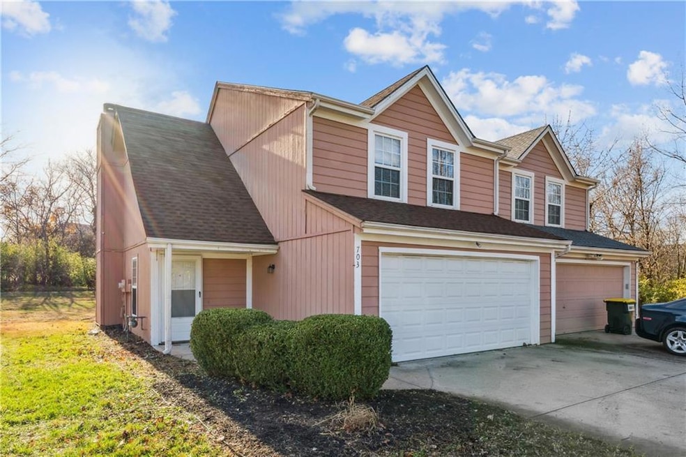
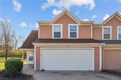
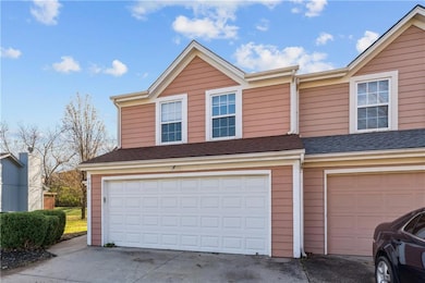

703 NE Swann Cir Lees Summit, MO 64086
Estimated payment $1,530/month
Highlights
- Traditional Architecture
- 1 Car Attached Garage
- Forced Air Heating and Cooling System
- Bernard C. Campbell Middle School Rated A
- Walk-In Closet
- Combination Kitchen and Dining Room
About This Home
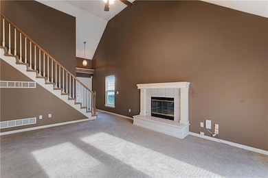
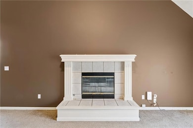
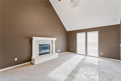
Charming and affordable, this move-in ready,3-bedroom, 2.5-bath half duplex in Lee’s Summit offers a spacious layout with a bright living room featuring a vaulted ceiling and cozy fireplace, a functional kitchen and dining area with room for updates, and three comfortable bedrooms including a private primary suite. The home has been well maintained and provides solid potential for personalization, along with practical perks like a 2-car garage, ample storage, and a backyard ready for your ideas, all in a desirable location close to schools, shopping, and convenient highway access.
Listing Agent
Keller Williams Platinum Prtnr Brokerage Phone: 816-875-1715 Listed on: 11/25/2025

Townhouse Details
Home Type
- Townhome
Est. Annual Taxes
- $2,847
Year Built
- Built in 1997
Lot Details
- 6,318 Sq Ft Lot
- Partially Fenced Property
HOA Fees
- $8 Monthly HOA Fees
Parking
- 1 Car Attached Garage
Home Design
- Half Duplex
- Traditional Architecture
- Slab Foundation
- Frame Construction
- Composition Roof
Interior Spaces
- 1,412 Sq Ft Home
- 1.5-Story Property
- Ceiling Fan
- Gas Fireplace
- Living Room with Fireplace
- Combination Kitchen and Dining Room
- Dishwasher
- Laundry in Kitchen
Flooring
- Carpet
- Vinyl
Bedrooms and Bathrooms
- 3 Bedrooms
- Walk-In Closet
Utilities
- Forced Air Heating and Cooling System
Community Details
- Maple Tree Manor HOA
- Maple Tree Manor Subdivision
Listing and Financial Details
- Assessor Parcel Number 52-830-98-46-00-0-00-000
- $0 special tax assessment
Map
Home Values in the Area
Average Home Value in this Area
Tax History
| Year | Tax Paid | Tax Assessment Tax Assessment Total Assessment is a certain percentage of the fair market value that is determined by local assessors to be the total taxable value of land and additions on the property. | Land | Improvement |
|---|---|---|---|---|
| 2025 | $2,847 | $37,189 | $8,318 | $28,871 |
| 2024 | $2,826 | $39,425 | $4,712 | $34,713 |
| 2023 | $2,826 | $39,426 | $4,076 | $35,350 |
| 2022 | $2,270 | $28,120 | $3,876 | $24,244 |
| 2021 | $2,317 | $28,120 | $3,876 | $24,244 |
| 2020 | $2,057 | $24,717 | $3,876 | $20,841 |
| 2019 | $2,000 | $24,717 | $3,876 | $20,841 |
| 2018 | $1,784,401 | $18,768 | $1,830 | $16,938 |
| 2017 | $1,637 | $18,768 | $1,830 | $16,938 |
| 2016 | $1,612 | $18,297 | $1,805 | $16,492 |
| 2014 | $1,452 | $16,150 | $2,016 | $14,134 |
Property History
| Date | Event | Price | List to Sale | Price per Sq Ft |
|---|---|---|---|---|
| 12/02/2025 12/02/25 | For Sale | $245,000 | -- | $174 / Sq Ft |
Purchase History
| Date | Type | Sale Price | Title Company |
|---|---|---|---|
| Warranty Deed | -- | Accommodation | |
| Interfamily Deed Transfer | -- | None Available | |
| Interfamily Deed Transfer | -- | None Available |
Mortgage History
| Date | Status | Loan Amount | Loan Type |
|---|---|---|---|
| Open | $442,425 | Future Advance Clause Open End Mortgage |
Source: Heartland MLS
MLS Number: 2589193
APN: 52-830-98-46-00-0-00-000
Disclaimer: Certain information contained herein is derived from information provided by parties other than Homes.com. All information provided is deemed reliable, but is not guaranteed to be accurate and should be independently verified.
![]() Based on information submitted to the MLS GRID as of [see last changed date above]. All data is obtained from various sources and may not have been verified by broker or MLS GRID. Supplied Open House Information is subject to change without notice. All information should be independently reviewed and verified for accuracy. Properties may or may not be listed by the office/agent presenting the information. Some IDX listings have been excluded from this website. Prices displayed on all Sold listings are the Last Known Listing Price and may not be the actual selling price.
Based on information submitted to the MLS GRID as of [see last changed date above]. All data is obtained from various sources and may not have been verified by broker or MLS GRID. Supplied Open House Information is subject to change without notice. All information should be independently reviewed and verified for accuracy. Properties may or may not be listed by the office/agent presenting the information. Some IDX listings have been excluded from this website. Prices displayed on all Sold listings are the Last Known Listing Price and may not be the actual selling price.
Listing Information presented by local MLS brokerage: TEN-X, INC., local REALTOR®- Arlene Richardson - (888)952-6393
The Digital Millennium Copyright Act of 1998, 17 U.S.C. § 512 (the “DMCA”) provides recourse for copyright owners who believe that material appearing on the Internet infringes their rights under U.S. copyright law. If you believe in good faith that any content or material made available in connection with our website or services infringes your copyright, you (or your agent) may send us a notice requesting that the content or material be removed, or access to it blocked.
Notices must be sent in writing by email to DMCAnotice@MLSGrid.com.
The DMCA requires that your notice of alleged copyright infringement include the following information:
(1) description of the copyrighted work that is the subject of claimed infringement;
(2) description of the alleged infringing content and information sufficient to permit us to locate the content;
(3) contact information for you, including your address, telephone number and email address;
(4) a statement by you that you have a good faith belief that the content in the manner complained of is not authorized by the copyright owner, or its agent, or by the operation of any law;
(5) a statement by you, signed under penalty of perjury, that the information in the notification is accurate and that you have the authority to enforce the copyrights that are claimed to be infringed; and
(6) a physical or electronic signature of the copyright owner or a person authorized to act on the copyright owner’s behalf. Failure to include all of the above information may result in the delay of the processing of your complaint.
- 333 NE Woodbury Dr
- 1020 NE Woodbury Ln
- 403 NE Howard Ave
- 104 NE Orchard St
- 1300 NE Browning Ln
- 309 NE Corder St
- 710 NE Westwind Dr
- 307 NE Sharon Dr
- 1020 NE Lindsay Ave
- 304 NE Independence Ave Unit B
- 315 NE Forest Ave
- 1121 NE Ridgeview Dr
- 711 NE Ash St Unit B
- 510 NE Thames Dr
- 313 NE Short St
- 310 NE Green St
- 210 NE Maple St
- 705/707 SE High N A
- 717 NE Mulberry St
- 404 NE Castle Dr
- 701 NE Tudor Rd
- 1102 NE Independence Ave
- 409 N E Sharon St
- 611 NE Ridgeview Dr
- 816 NE Westwind Ln
- 1121 NE Ridgeview Dr
- 1100 NE Bryco Dr
- 217 NE Independence Ave
- 518 SE Lee Haven Dr
- 1133 NE Banner Dr
- 1018 NE Trailwood Dr
- 1109 NE Columbus St
- 216 NE Douglas St
- 216 NE Douglas St
- 114 SE Douglas St
- 1502 NW 1st St
- 789 NW Donovan Rd
- 837 Donovan Rd
- 600-608 SE State Route 291
- 1022 SE 5th Terrace