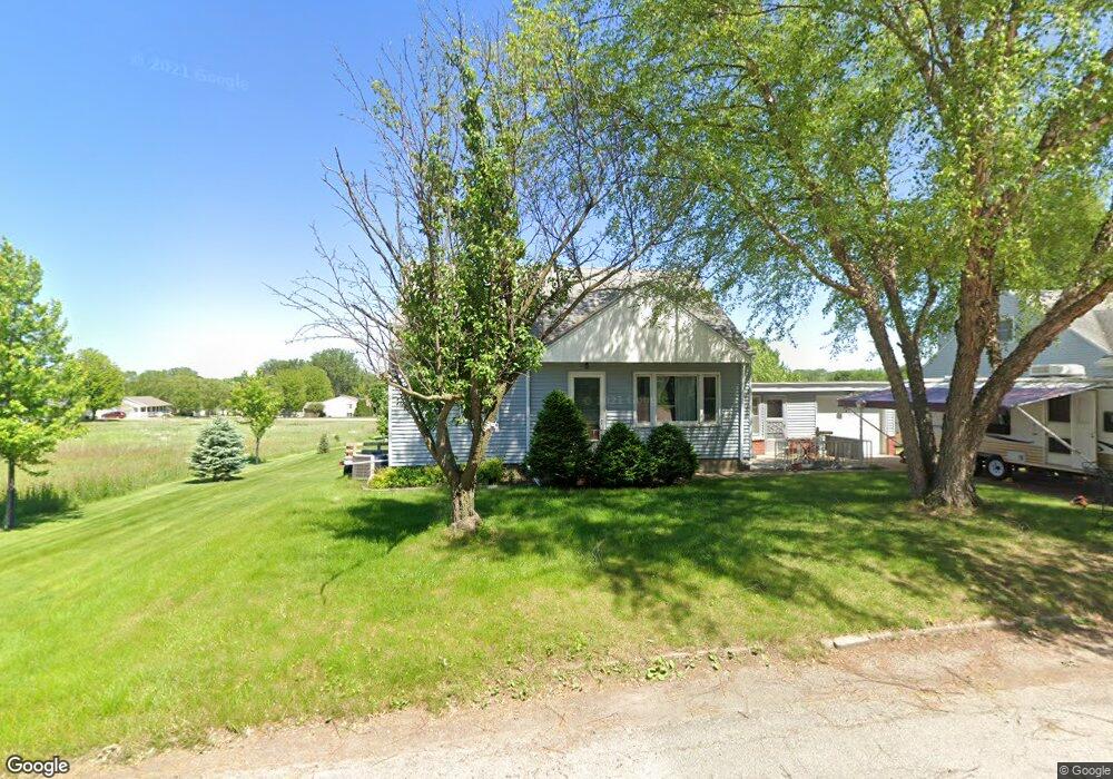
703 Stanley St Cedar Falls, IA 50613
Estimated Value: $224,091 - $282,000
3
Beds
2
Baths
1,464
Sq Ft
$171/Sq Ft
Est. Value
About This Home
This home is located at 703 Stanley St, Cedar Falls, IA 50613 and is currently estimated at $250,773, approximately $171 per square foot. 703 Stanley St is a home located in Black Hawk County with nearby schools including Helen A. Hansen Elementary School, Holmes Junior High School, and Cedar Falls High School.
Ownership History
Date
Name
Owned For
Owner Type
Purchase Details
Closed on
Mar 3, 2015
Sold by
Weichers Andrew R and Weichers Amanda J
Bought by
King Melody K
Current Estimated Value
Home Financials for this Owner
Home Financials are based on the most recent Mortgage that was taken out on this home.
Original Mortgage
$124,208
Outstanding Balance
$95,099
Interest Rate
3.75%
Mortgage Type
FHA
Estimated Equity
$155,674
Purchase Details
Closed on
Oct 24, 2012
Sold by
Boyce Frank A
Bought by
Dewitt Ronald I and Dewitt Carol
Create a Home Valuation Report for This Property
The Home Valuation Report is an in-depth analysis detailing your home's value as well as a comparison with similar homes in the area
Home Values in the Area
Average Home Value in this Area
Purchase History
| Date | Buyer | Sale Price | Title Company |
|---|---|---|---|
| King Melody K | $126,000 | None Available | |
| Dewitt Ronald I | $120,000 | None Available |
Source: Public Records
Mortgage History
| Date | Status | Borrower | Loan Amount |
|---|---|---|---|
| Open | King Melody K | $124,208 |
Source: Public Records
Tax History
| Year | Tax Paid | Tax Assessment Tax Assessment Total Assessment is a certain percentage of the fair market value that is determined by local assessors to be the total taxable value of land and additions on the property. | Land | Improvement |
|---|---|---|---|---|
| 2025 | $2,538 | $191,150 | $22,950 | $168,200 |
| 2024 | $2,538 | $167,990 | $22,950 | $145,040 |
| 2023 | $2,098 | $167,990 | $22,950 | $145,040 |
| 2022 | $2,122 | $122,560 | $22,950 | $99,610 |
| 2021 | $1,980 | $122,560 | $22,950 | $99,610 |
| 2020 | $1,936 | $114,910 | $15,300 | $99,610 |
| 2019 | $1,936 | $114,910 | $15,300 | $99,610 |
| 2018 | $1,934 | $114,910 | $15,300 | $99,610 |
| 2017 | $1,934 | $113,390 | $15,300 | $98,090 |
| 2016 | $1,768 | $108,720 | $15,300 | $93,420 |
| 2015 | $1,768 | $108,720 | $15,300 | $93,420 |
| 2014 | $1,944 | $108,720 | $15,300 | $93,420 |
Source: Public Records
Map
Nearby Homes
- Lot 14 Street C
- Lot 18 Street D
- 3702 Apollo St
- 3413 Pheasant Dr
- 4128 Shocker Rd
- 0 W 1st St
- 114 Parkgate Rd
- 4124 Thresher Ct Unit 306
- 405 Golden Ln
- 328 Parkgate Rd
- 435 Autumn Ln Unit 3
- 435 Autumn Ln Unit 2
- 435 Autumn Ln Unit 1
- 514 Autumn Ln
- 4305 Autumn Ridge Rd Unit 214
- 455 Autumn Ln Unit 6
- 455 Autumn Ln Unit 5
- 2124 Minnetonka Dr
- 4320 Autumn Ridge Rd
- 2802 Cottage Row Rd
- 625 Stanley St
- 619 Stanley St
- 704 Stanley St
- 611 Stanley St
- 612 Stanley St
- 702 Clair St
- 605 Stanley St
- 3521 W 1st St
- 703 Shirley St
- 625 Shirley St
- 605 Shirley St
- 701 Lakeshore Dr
- 3315 W 1st St
- 700 Lakeshore Dr
- 704 Shirley St
- 626 Shirley St
- 707 Lakeshore Dr
- 3512 W 1st St
- 606 Shirley St
- 706 Lakeshore Dr
Your Personal Tour Guide
Ask me questions while you tour the home.