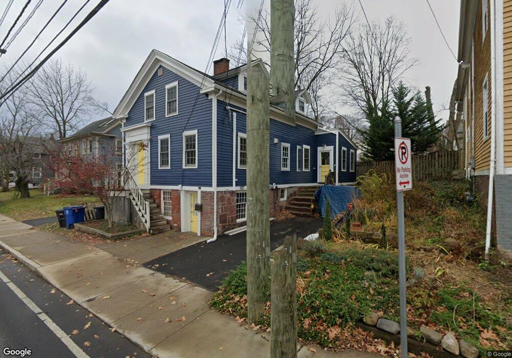
705 Quinnipiac Ave New Haven, CT 06513
Fair Haven Heights NeighborhoodEstimated Value: $309,455 - $339,000
3
Beds
2
Baths
1,712
Sq Ft
$192/Sq Ft
Est. Value
About This Home
This home is located at 705 Quinnipiac Ave, New Haven, CT 06513 and is currently estimated at $328,614, approximately $191 per square foot. 705 Quinnipiac Ave is a home located in New Haven County with nearby schools including Ross Woodward, St Francis & St Rose Of Lima School, and All Nations Christian Academy.
Ownership History
Date
Name
Owned For
Owner Type
Purchase Details
Closed on
Dec 4, 2002
Sold by
Guzzio Richard P and Demusis Anthony A
Bought by
Hartjen Anne K
Current Estimated Value
Home Financials for this Owner
Home Financials are based on the most recent Mortgage that was taken out on this home.
Original Mortgage
$145,950
Interest Rate
6.34%
Create a Home Valuation Report for This Property
The Home Valuation Report is an in-depth analysis detailing your home's value as well as a comparison with similar homes in the area
Home Values in the Area
Average Home Value in this Area
Purchase History
| Date | Buyer | Sale Price | Title Company |
|---|---|---|---|
| Hartjen Anne K | $104,500 | -- |
Source: Public Records
Mortgage History
| Date | Status | Borrower | Loan Amount |
|---|---|---|---|
| Closed | Hartjen Anne K | $140,000 | |
| Closed | Hartjen Anne K | $13,500 | |
| Closed | Hartjen Anne K | $140,000 | |
| Closed | Hartjen Anne K | $145,950 |
Source: Public Records
Tax History Compared to Growth
Tax History
| Year | Tax Paid | Tax Assessment Tax Assessment Total Assessment is a certain percentage of the fair market value that is determined by local assessors to be the total taxable value of land and additions on the property. | Land | Improvement |
|---|---|---|---|---|
| 2025 | $4,793 | $121,660 | $36,610 | $85,050 |
| 2024 | $4,684 | $121,660 | $36,610 | $85,050 |
| 2023 | $4,526 | $121,660 | $36,610 | $85,050 |
| 2022 | $4,836 | $121,660 | $36,610 | $85,050 |
| 2021 | $4,331 | $98,700 | $17,570 | $81,130 |
| 2020 | $4,294 | $97,860 | $17,570 | $80,290 |
| 2019 | $4,206 | $97,860 | $17,570 | $80,290 |
| 2018 | $4,206 | $97,860 | $17,570 | $80,290 |
| 2017 | $3,785 | $97,860 | $17,570 | $80,290 |
| 2016 | $4,357 | $104,860 | $26,390 | $78,470 |
| 2015 | $4,357 | $104,860 | $26,390 | $78,470 |
| 2014 | $4,357 | $104,860 | $26,390 | $78,470 |
Source: Public Records
Map
Nearby Homes
- 714 Quinnipiac Ave
- 728 Quinnipiac Ave
- 686 Quinnipiac Ave
- 674 Quinnipiac Ave
- 314 Lenox St
- 100 Front St Unit 100
- 265 Lexington Ave
- 533 Quinnipiac Ave
- 25 Pine St
- 916 Quinnipiac Ave Unit 2
- 116 E Pearl St
- 76 Front St Unit 76
- 22 Downing St
- 932 Quinnipiac Ave Unit 5
- 926 Quinnipiac Ave Unit 1
- 926 Quinnipiac Ave Unit 8
- 71 Houston St
- 8 Front St Unit D
- 43 E Pearl St
- 72 Pierpont St
- 701 Quinnipiac Ave
- 715 Quinnipiac Ave
- 715 Quinnipiac Ave Unit 1
- 370 Lenox St
- 374 Lenox St
- 378 Lenox St
- 366 Lenox St
- 719 Quinnipiac Ave
- 7 Clifton St
- 693 Quinnipiac Ave Unit 1
- 48 E Grand Ave
- 46 E Grand Ave
- 671 Quinnipiac Ave
- 673 Quinnipiac Ave
- 679 Quinnipiac Ave
- 677 Quinnipiac Ave
- 681 Quinnipiac Ave
- 687 Quinnipiac Ave
- 685 Quinnipiac Ave
- 691 Quinnipiac Ave