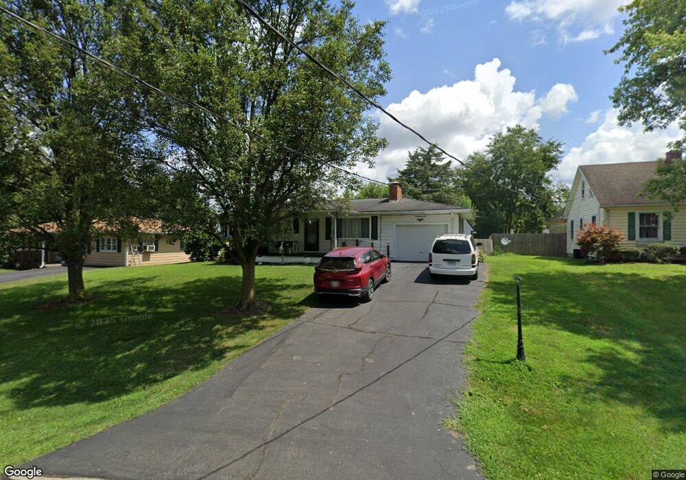
7066 Howard Rd Franklin, OH 45005
Estimated Value: $197,302 - $221,000
3
Beds
2
Baths
1,248
Sq Ft
$168/Sq Ft
Est. Value
About This Home
This home is located at 7066 Howard Rd, Franklin, OH 45005 and is currently estimated at $209,076, approximately $167 per square foot. 7066 Howard Rd is a home located in Warren County with nearby schools including Franklin High School.
Ownership History
Date
Name
Owned For
Owner Type
Purchase Details
Closed on
Nov 28, 2016
Sold by
Glover Barry D and Glover Sharon
Bought by
Vest David W and Vest Bridget G
Current Estimated Value
Purchase Details
Closed on
Nov 1, 2016
Sold by
Glover Barry D and Glover Sharon
Bought by
Vest David W and Vest Bridget G
Purchase Details
Closed on
Oct 19, 2007
Sold by
Glover Barry D and Fugate Karen S
Bought by
Glover Barry D
Create a Home Valuation Report for This Property
The Home Valuation Report is an in-depth analysis detailing your home's value as well as a comparison with similar homes in the area
Home Values in the Area
Average Home Value in this Area
Purchase History
| Date | Buyer | Sale Price | Title Company |
|---|---|---|---|
| Vest David W | $56,000 | None Available | |
| Vest David W | $56,000 | Attorney | |
| Glover Barry D | -- | None Available | |
| Glover Arthur R | -- | Attorney |
Source: Public Records
Tax History
| Year | Tax Paid | Tax Assessment Tax Assessment Total Assessment is a certain percentage of the fair market value that is determined by local assessors to be the total taxable value of land and additions on the property. | Land | Improvement |
|---|---|---|---|---|
| 2025 | $1,902 | $51,830 | $11,710 | $40,120 |
| 2024 | $1,902 | $51,830 | $11,710 | $40,120 |
| 2023 | $1,578 | $40,047 | $7,353 | $32,693 |
| 2022 | $1,535 | $40,047 | $7,354 | $32,694 |
| 2021 | $1,453 | $40,047 | $7,354 | $32,694 |
| 2020 | $1,409 | $35,438 | $6,507 | $28,931 |
| 2019 | $1,276 | $35,438 | $6,507 | $28,931 |
| 2018 | $1,278 | $35,438 | $6,507 | $28,931 |
| 2017 | $1,109 | $29,708 | $5,936 | $23,772 |
| 2016 | $1,622 | $29,708 | $5,936 | $23,772 |
| 2015 | $1,624 | $29,708 | $5,936 | $23,772 |
| 2014 | $1,120 | $29,710 | $5,940 | $23,770 |
| 2013 | $952 | $32,580 | $6,510 | $26,070 |
Source: Public Records
Map
Nearby Homes
- 0 Kathy Ln Unit 1834240
- 0 Kathy Ln Unit 930066
- 7189 Shaker Rd
- 218 Roberts Ave
- 5684 Olive Rd
- 139 E 6th St
- 388 Thomas Dr
- 1200 Riley Blvd
- 6323 Shaker Rd
- 1117 S Main St
- 409 Millard Dr
- 0 E 4th St
- 627 S River St
- 760 David Blvd
- 995 E 4th St
- 747 David Blvd
- 202 E 2nd St
- 100 Pleasant Hill Blvd
- 210 N Riley Blvd
- 551 E 2nd St
- 7078 Howard Rd
- 7052 Howard Rd
- 7042 Howard Rd
- 7135 State Route 123
- 7149 State Route 123
- 7123 State Route 123
- 7135 Ohio 123
- 7149 Ohio 123
- 7069 Howard Rd
- 7045 Howard Rd
- 7024 Howard Rd
- 7023 Howard Rd
- 7175 State Route 123
- 7093 State Route 123
- 7089 Howard Rd
- 7130 Randall Rd
- 7057 Howard Rd
- 7009 Howard Rd
- 7008 Howard Rd
- 7077 State Route 123
Your Personal Tour Guide
Ask me questions while you tour the home.