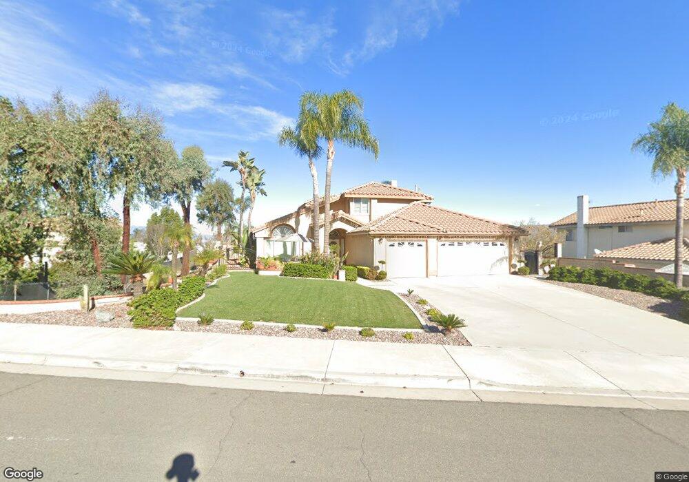
7068 Westport St Riverside, CA 92506
Mission Grove NeighborhoodEstimated Value: $719,883 - $816,000
4
Beds
3
Baths
2,018
Sq Ft
$382/Sq Ft
Est. Value
About This Home
This home is located at 7068 Westport St, Riverside, CA 92506 and is currently estimated at $770,471, approximately $381 per square foot. 7068 Westport St is a home located in Riverside County with nearby schools including William Howard Taft Elementary School, Amelia Earhart Middle School, and Martin Luther King Junior High School.
Ownership History
Date
Name
Owned For
Owner Type
Purchase Details
Closed on
Oct 28, 2016
Sold by
Martinez Pedro N and Quinones Martinez Brenda
Bought by
Martinez Pedro Negrete and Quinones Martinez Brenda
Current Estimated Value
Create a Home Valuation Report for This Property
The Home Valuation Report is an in-depth analysis detailing your home's value as well as a comparison with similar homes in the area
Home Values in the Area
Average Home Value in this Area
Purchase History
| Date | Buyer | Sale Price | Title Company |
|---|---|---|---|
| Martinez Pedro Negrete | -- | None Available |
Source: Public Records
Tax History
| Year | Tax Paid | Tax Assessment Tax Assessment Total Assessment is a certain percentage of the fair market value that is determined by local assessors to be the total taxable value of land and additions on the property. | Land | Improvement |
|---|---|---|---|---|
| 2025 | $4,618 | $432,312 | $147,161 | $285,151 |
| 2023 | $4,618 | $415,527 | $141,448 | $274,079 |
| 2022 | $4,510 | $407,380 | $138,675 | $268,705 |
| 2021 | $4,450 | $399,393 | $135,956 | $263,437 |
| 2020 | $4,416 | $395,298 | $134,562 | $260,736 |
| 2019 | $4,331 | $387,548 | $131,924 | $255,624 |
| 2018 | $4,246 | $379,950 | $129,339 | $250,611 |
| 2017 | $4,169 | $372,501 | $126,803 | $245,698 |
| 2016 | $3,900 | $365,198 | $124,317 | $240,881 |
| 2015 | $3,843 | $359,713 | $122,450 | $237,263 |
| 2014 | $3,806 | $352,668 | $120,052 | $232,616 |
Source: Public Records
Map
Nearby Homes
- 1003 Clearwood Ave
- 120 Sandpoint Ln
- 110 Sandpoint Ln
- 901 Clearwood Ave
- 7320 Barnstable Place
- 200 E Alessandro Blvd Unit 94
- 7158 Golden Vale Dr
- 305 Mission Grove Pkwy N
- 6910 Sandtrack Rd
- 7007 Golden Vale Dr
- 6801 Rycroft Dr
- 7639 Hillhurst Dr
- 6717 Mission Grove Pkwy N
- 6744 Mission Grove Pkwy N
- 7390 Corinthian Way
- 6712 Mission Grove Pkwy N
- 14119 Ashton Ln
- 7361 Via Vista Dr
- 14435 Wood Rd
- 14420 Merlot Ct
- 7074 Westport St
- 7058 Westport St
- 7096 City View Cir
- 7080 City View Cir
- 7080 Westport St
- 7073 Westport St
- 7048 Westport St
- 7067 Westport St
- 7079 Westport St
- 7061 Westport St
- 7055 Westport St
- 7075 City View Cir
- 7086 Westport St
- 7064 City View Cir
- 7049 Westport St
- 7085 Westport St
- 1038 New Star Cir
- 1052 New Star Cir
- 945 High Peak Dr
- 955 High Peak Dr
Your Personal Tour Guide
Ask me questions while you tour the home.