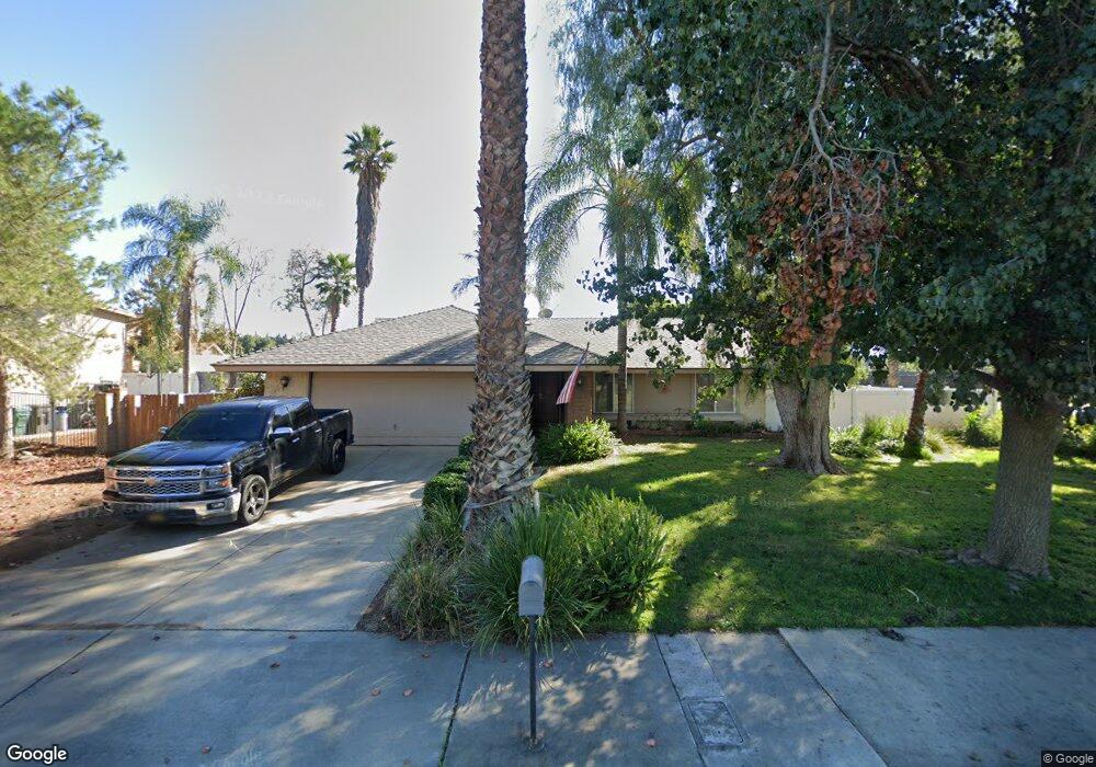
7070 Fireside Dr Riverside, CA 92506
Hawarden Hills NeighborhoodEstimated Value: $552,000 - $680,000
3
Beds
2
Baths
1,324
Sq Ft
$477/Sq Ft
Est. Value
About This Home
This home is located at 7070 Fireside Dr, Riverside, CA 92506 and is currently estimated at $631,226, approximately $476 per square foot. 7070 Fireside Dr is a home located in Riverside County with nearby schools including Washington Elementary School, Matthew Gage Middle School, and Polytechnic High School.
Ownership History
Date
Name
Owned For
Owner Type
Purchase Details
Closed on
May 21, 2021
Sold by
Anderson Henning G and Anderson Elaine M
Bought by
Anderson Cord I and Rios Avril
Current Estimated Value
Home Financials for this Owner
Home Financials are based on the most recent Mortgage that was taken out on this home.
Original Mortgage
$392,000
Outstanding Balance
$354,133
Interest Rate
2.9%
Mortgage Type
New Conventional
Estimated Equity
$277,093
Purchase Details
Closed on
Oct 21, 2020
Sold by
Anderson Henning G and Anderson Elaine M
Bought by
Anderson Henning G and Anderson Elaine M
Purchase Details
Closed on
May 28, 1997
Sold by
Colyer Greg W
Bought by
Anderson Henning G and Anderson Elaine M
Home Financials for this Owner
Home Financials are based on the most recent Mortgage that was taken out on this home.
Original Mortgage
$130,804
Interest Rate
7.7%
Mortgage Type
FHA
Create a Home Valuation Report for This Property
The Home Valuation Report is an in-depth analysis detailing your home's value as well as a comparison with similar homes in the area
Home Values in the Area
Average Home Value in this Area
Purchase History
| Date | Buyer | Sale Price | Title Company |
|---|---|---|---|
| Anderson Cord I | -- | First American Title | |
| Anderson Henning G | -- | None Available | |
| Anderson Henning G | $133,000 | First American Title Ins Co |
Source: Public Records
Mortgage History
| Date | Status | Borrower | Loan Amount |
|---|---|---|---|
| Open | Anderson Cord I | $392,000 | |
| Previous Owner | Anderson Henning G | $130,804 |
Source: Public Records
Tax History
| Year | Tax Paid | Tax Assessment Tax Assessment Total Assessment is a certain percentage of the fair market value that is determined by local assessors to be the total taxable value of land and additions on the property. | Land | Improvement |
|---|---|---|---|---|
| 2025 | $2,268 | $212,336 | $63,848 | $148,488 |
| 2023 | $2,268 | $204,095 | $61,371 | $142,724 |
| 2022 | $5,094 | $459,000 | $102,000 | $357,000 |
| 2021 | $2,194 | $196,161 | $58,986 | $137,175 |
| 2020 | $2,177 | $194,151 | $58,384 | $135,767 |
| 2019 | $2,136 | $190,345 | $57,240 | $133,105 |
| 2018 | $2,093 | $186,614 | $56,118 | $130,496 |
| 2017 | $2,055 | $182,956 | $55,018 | $127,938 |
| 2016 | $1,925 | $179,370 | $53,940 | $125,430 |
| 2015 | $1,896 | $176,678 | $53,131 | $123,547 |
| 2014 | $1,876 | $173,220 | $52,092 | $121,128 |
Source: Public Records
Map
Nearby Homes
- 7247 Pontoosuc Ave
- 2390 Prenda Ave
- 7008 Hawarden Dr
- 2100 Hathaway Place
- 2110 Hathaway Place
- 1389 Ocotillo Dr
- 2875 Washington St
- 1383 Ocotillo Dr
- 2906 Miguel St
- 2656 Maude St
- 7252 Boice Ln
- 2542 Adage Way
- 2994 David St
- 6872 Chartwell Dr
- 7450 Emerald St
- 3076 Ronald St
- 7384 Golden Star Ave
- 2019 Polo Ct
- 0 Ysmael Villegas St
- 6959 Wyndham Hill Dr
- 7060 Fireside Dr
- 7067 Gladys Rd
- 7077 Fireside Dr
- 7050 Fireside Dr
- 7067 Fireside Dr
- 7057 Gladys Rd
- 7057 Fireside Dr
- 2372 Engel Dr
- 7070 Moonstone Cir
- 7060 Moonstone Cir
- 7040 Fireside Dr
- 2414 Peppertree Ln
- 7050 Moonstone Cir
- 2369 Engel Dr
- 2424 Peppertree Ln
- 2362 Engel Dr
- 2370 Peppertree Ln
- 7077 Moonstone Cir
- 2395 Peppertree Ln
- 2405 Peppertree Ln
Your Personal Tour Guide
Ask me questions while you tour the home.