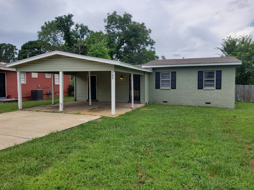
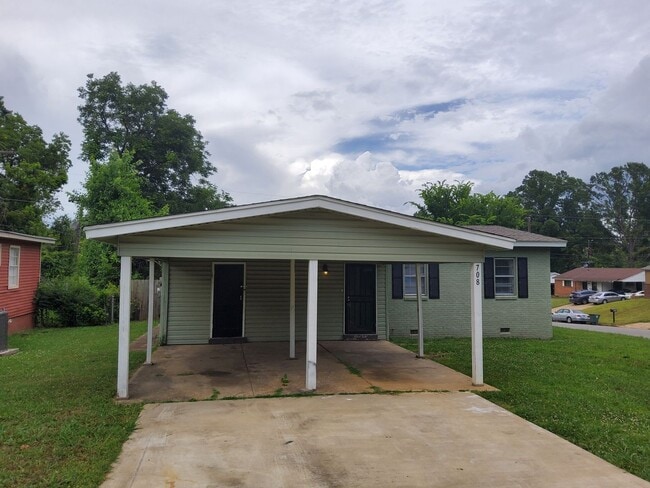
708 Mohawk Ave Memphis, TN 38109
Westwood NeighborhoodEstimated Value: $95,000 - $131,000
3
Beds
2
Baths
1,136
Sq Ft
$98/Sq Ft
Est. Value
About This Home
This home is located at 708 Mohawk Ave, Memphis, TN 38109 and is currently estimated at $111,832, approximately $98 per square foot. 708 Mohawk Ave is a home located in Shelby County with nearby schools including Levi Elementary School, Chickasaw Middle School, and Westwood High School.
Ownership History
Date
Name
Owned For
Owner Type
Purchase Details
Closed on
Jan 22, 2024
Sold by
Menace To Sobriety Llc
Bought by
Daniel G Burkhead Revocable Trust and Burkhead
Current Estimated Value
Purchase Details
Closed on
Nov 1, 2022
Sold by
Parikh Aj
Bought by
Menace To Sobriety Llc
Purchase Details
Closed on
Nov 18, 2020
Sold by
Millennium Trust Company
Bought by
Parikh Aj
Home Financials for this Owner
Home Financials are based on the most recent Mortgage that was taken out on this home.
Original Mortgage
$52,500
Interest Rate
2.8%
Mortgage Type
New Conventional
Purchase Details
Closed on
Jul 15, 2019
Sold by
Equity Trust Company
Bought by
Millennium Trust Company and Fbo Hans Kruger Traditional Ira
Purchase Details
Closed on
Oct 26, 2018
Sold by
Global Housing Investments Llc
Bought by
Equity Trust Company and Hans Kruger
Purchase Details
Closed on
Apr 27, 2018
Sold by
West Laundon
Bought by
Global Housing Investments Llc
Purchase Details
Closed on
Sep 14, 2017
Sold by
Moragne Dexter
Bought by
West Laundon
Purchase Details
Closed on
Oct 27, 2008
Sold by
Us Bank National Association
Bought by
Moragne Dexter
Purchase Details
Closed on
Aug 26, 2008
Sold by
Thomas Latrice La Fae
Bought by
Us Bank Na
Purchase Details
Closed on
Oct 25, 2005
Sold by
Rayford Kevin
Bought by
Thomas Latrice Lafae
Home Financials for this Owner
Home Financials are based on the most recent Mortgage that was taken out on this home.
Original Mortgage
$54,900
Interest Rate
5.71%
Mortgage Type
Fannie Mae Freddie Mac
Purchase Details
Closed on
Aug 4, 2005
Sold by
Lasalle Bank Na
Bought by
Rayford Kevin and Helping Hands Management
Purchase Details
Closed on
Oct 7, 2004
Sold by
Jones Michael
Bought by
Lasalle Bank Na and Lasalle National Bank
Purchase Details
Closed on
Feb 5, 1997
Sold by
Jones Cheryl L
Bought by
Jones Michael
Create a Home Valuation Report for This Property
The Home Valuation Report is an in-depth analysis detailing your home's value as well as a comparison with similar homes in the area
Home Values in the Area
Average Home Value in this Area
Purchase History
Date | Buyer | Sale Price | Title Company |
---|---|---|---|
Daniel G Burkhead Revocable Trust | -- | None Listed On Document | |
Menace To Sobriety Llc | $105,000 | Delta Title Services | |
Parikh Aj | $70,000 | Spruce Title Co | |
Millennium Trust Company | -- | None Available | |
Equity Trust Company | $71,555 | Meridian Title Corp | |
Global Housing Investments Llc | -- | None Available | |
West Laundon | -- | None Available | |
Moragne Dexter | $15,000 | Signature Title Llc | |
Us Bank Na | $41,621 | None Available | |
Thomas Latrice Lafae | $61,000 | Nations Title Of Tn Inc | |
Rayford Kevin | $22,000 | -- | |
Lasalle Bank Na | $44,200 | -- | |
Jones Michael | -- | First Title Corporation |
Source: Public Records
Mortgage History
Date | Status | Borrower | Loan Amount |
---|---|---|---|
Previous Owner | Parikh Aj | $52,500 | |
Previous Owner | Thomas Latrice Lafae | $54,900 | |
Previous Owner | Jones Michael | $36,000 | |
Previous Owner | Jones Michael | $997 | |
Previous Owner | Jones Michael | $1,794 |
Source: Public Records
Tax History Compared to Growth
Tax History
Year | Tax Paid | Tax Assessment Tax Assessment Total Assessment is a certain percentage of the fair market value that is determined by local assessors to be the total taxable value of land and additions on the property. | Land | Improvement |
---|---|---|---|---|
2025 | $571 | $24,450 | $2,625 | $21,825 |
2024 | $571 | $16,850 | $2,175 | $14,675 |
2023 | $1,026 | $16,850 | $2,175 | $14,675 |
2022 | $1,026 | $16,850 | $2,175 | $14,675 |
2021 | $1,038 | $16,850 | $2,175 | $14,675 |
2020 | $484 | $15,150 | $2,175 | $12,975 |
2019 | $484 | $15,150 | $2,175 | $12,975 |
2018 | $401 | $12,550 | $2,175 | $10,375 |
2017 | $411 | $12,550 | $2,175 | $10,375 |
2016 | $508 | $11,625 | $0 | $0 |
2014 | $508 | $11,625 | $0 | $0 |
Source: Public Records
Map
Nearby Homes
- 648 Mohawk Ave
- 648 Pawnee Ave
- 634 Leacrest Ave
- 436 Western Park Dr
- 530 W Raines Rd
- 0 Ford Rd
- 4424 Deerland St
- 4335 Ford Rd
- 1307 W Raines Rd
- 4014 Oakshire Cove
- 4010 Oakshire St
- 1010 Leacrest Ave
- 975 Norfleet Ave
- 686 Westview Rd
- 781 W Levi Rd
- 4041 Ebbtide St
- 177 W Levi Rd
- 4539 Weaver Rd SW
- 4487 Weaver Rd S
- 576 Monteagle Dr
- 708 Mohawk Ave
- 716 Mohawk Ave
- 4229 Deerland St
- 722 Mohawk Ave
- 4236 Deerland St
- 4223 Deerland St
- 707 Mohawk Ave
- 4228 Deerland St
- 715 Mohawk Ave
- 4222 Bow St
- 4217 Deerland St
- 4222 Deerland St
- 693 Mohawk Ave
- 721 Mohawk Ave
- 686 Mohawk Ave
- 4216 Bow St
- 4263 Deerland St
- 4216 Deerland St
- 4211 Deerland St
- 685 Mohawk Ave