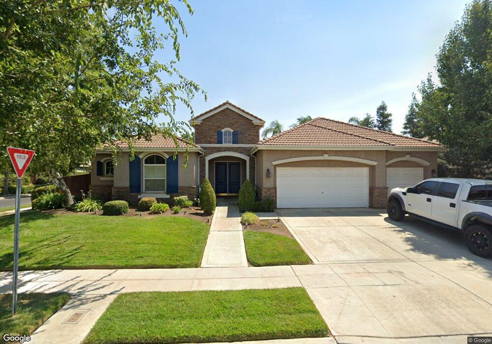
708 W Enterprise Ave Clovis, CA 93619
Estimated Value: $822,000 - $902,000
3
Beds
3
Baths
3,494
Sq Ft
$245/Sq Ft
Est. Value
About This Home
This home is located at 708 W Enterprise Ave, Clovis, CA 93619 and is currently estimated at $854,454, approximately $244 per square foot. 708 W Enterprise Ave is a home located in Fresno County with nearby schools including Garfield Elementary School, Alta Sierra Intermediate School, and Buchanan High School.
Ownership History
Date
Name
Owned For
Owner Type
Purchase Details
Closed on
Apr 22, 2024
Sold by
Isaak Timothy S and Isaak Janette I
Bought by
Timothy Isaak And Janette Isaak 2024 Revocabl and Isaak
Current Estimated Value
Purchase Details
Closed on
Jun 26, 2002
Sold by
Buchanan Estates Iv Inc
Bought by
Isaak Timothy S and Isaak Janette I
Home Financials for this Owner
Home Financials are based on the most recent Mortgage that was taken out on this home.
Original Mortgage
$300,700
Interest Rate
6.6%
Create a Home Valuation Report for This Property
The Home Valuation Report is an in-depth analysis detailing your home's value as well as a comparison with similar homes in the area
Home Values in the Area
Average Home Value in this Area
Purchase History
| Date | Buyer | Sale Price | Title Company |
|---|---|---|---|
| Timothy Isaak And Janette Isaak 2024 Revocabl | -- | None Listed On Document | |
| Isaak Timothy S | $357,500 | Chicago Title Co |
Source: Public Records
Mortgage History
| Date | Status | Borrower | Loan Amount |
|---|---|---|---|
| Previous Owner | Isaak Timothy S | $300,700 |
Source: Public Records
Tax History
| Year | Tax Paid | Tax Assessment Tax Assessment Total Assessment is a certain percentage of the fair market value that is determined by local assessors to be the total taxable value of land and additions on the property. | Land | Improvement |
|---|---|---|---|---|
| 2025 | $6,354 | $517,035 | $94,130 | $422,905 |
| 2023 | $6,100 | $496,960 | $90,476 | $406,484 |
| 2022 | $6,022 | $487,216 | $88,702 | $398,514 |
| 2021 | $5,842 | $477,663 | $86,963 | $390,700 |
| 2020 | $5,821 | $472,766 | $86,072 | $386,694 |
| 2019 | $5,712 | $463,497 | $84,385 | $379,112 |
| 2018 | $5,592 | $454,410 | $82,731 | $371,679 |
| 2017 | $5,500 | $445,501 | $81,109 | $364,392 |
| 2016 | $5,310 | $436,767 | $79,519 | $357,248 |
| 2015 | $5,219 | $430,207 | $78,325 | $351,882 |
| 2014 | $5,126 | $421,781 | $76,791 | $344,990 |
Source: Public Records
Map
Nearby Homes
- 635 W Quincy Ave
- 2878 E Omaha Ave
- 2776 E Muncie Ave
- 2825 E Quincy Ave
- 754 W Riviera Ln
- 2845 E Goshen Ave
- 2707 E Omaha Ave
- 2719 E Spice Way
- 8340 N Shallot Way
- 1634 N Cindy Ave
- 717 W Tivoli Ln
- 2740 E El Paso Ave
- 2991 E Cromwell Ave
- 8540 N Talladega Way
- 2567 E Tarragon Way
- 8450 N Saffron Ct
- 2545 E Goshen Ave
- 2417 E Omaha Ave
- 7835 N Matus Ave
- 8697 N Talladega Way
- 718 W Enterprise Ave
- 707 W Muncie Ave
- 668 W Enterprise Ave
- 717 W Muncie Ave
- 728 W Enterprise Ave
- 709 W Enterprise Ave
- 667 W Muncie Ave
- 719 W Enterprise Ave
- 727 W Muncie Ave
- 658 W Enterprise Ave
- 669 W Enterprise Ave
- 729 W Enterprise Ave
- 738 W Enterprise Ave
- 657 W Muncie Ave
- 659 W Enterprise Ave
- 737 W Muncie Ave
- 704 W Muncie Ave
- 726 W Omaha Ave
- 739 W Enterprise Ave
- 648 W Enterprise Ave
Your Personal Tour Guide
Ask me questions while you tour the home.