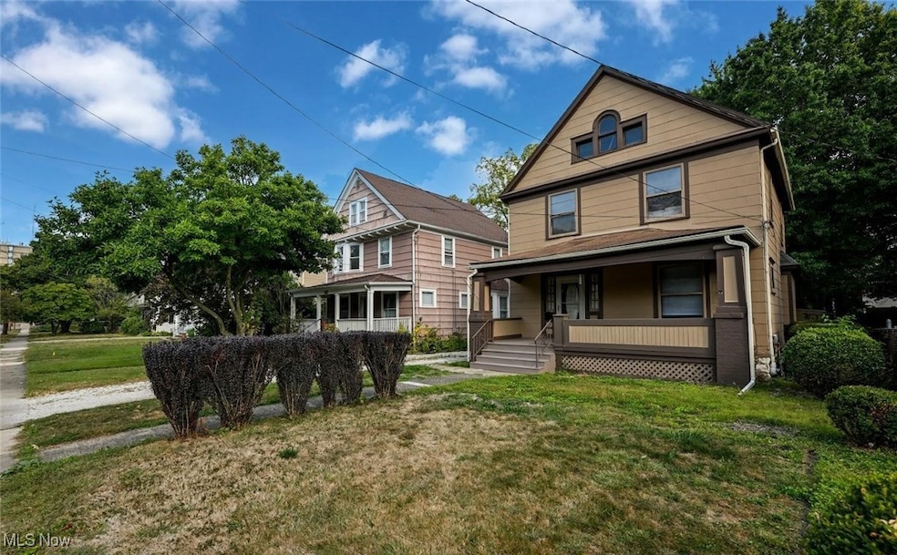


71 Dodge Ave Akron, OH 44302
Highland Square NeighborhoodEstimated payment $908/month
Highlights
- City View
- Property is near public transit
- Traditional Architecture
- Deck
- Freestanding Bathtub
- High Ceiling
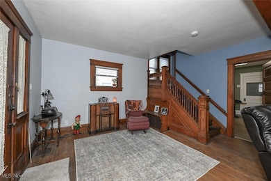
About This Home
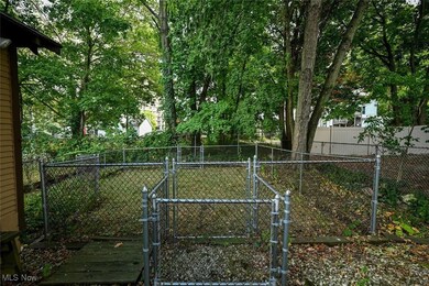
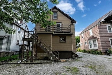
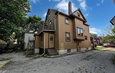
The heart of Highland Square! This old-world home offers 3 bedrooms, and 2 full bathrooms for sale in Highland Square. A mere 3-minute walk to Mustard Seed Market. This grand old home has ornate natural woodwork and a newly renovated retro kitchen with an expansive built in Pantry for storage. Newly renovated 1st floor full bathroom with a newer stand-up shower enclosure. The second floor offers 3 large bedrooms, one with a sink and antique cupboards for a possible den or poker room. There is also a second-floor deck with stairs to the ground level. The large second floor full bathroom offers a charming clawfoot tub with shower attachment with more built-in cabinets. The attic offers 2 rooms which could be additional bedrooms or study. Fenced in back yard enclosure for pets and one car garage with opener. Also on the property is a newer shed for lawn tools.
Listing Agent
Ohio Broker Direct Brokerage Email: 614-989-7215, joan@ohiobrokerdirect.com License #386319 Listed on: 09/24/2025
Co-Listing Agent
Ohio Broker Direct Brokerage Email: 614-989-7215, joan@ohiobrokerdirect.com License #2014005193
Home Details
Home Type
- Single Family
Est. Annual Taxes
- $2,261
Year Built
- Built in 1914 | Remodeled
Lot Details
- 5,920 Sq Ft Lot
- North Facing Home
- Chain Link Fence
- Front Yard
Parking
- 1 Car Detached Garage
- Gravel Driveway
- Shared Driveway
- On-Street Parking
Property Views
- City
- Neighborhood
Home Design
- Traditional Architecture
- Brick Exterior Construction
- Block Foundation
- Slate Roof
- Wood Siding
- Concrete Siding
- Cement Siding
Interior Spaces
- 1,920 Sq Ft Home
- 3-Story Property
- Built-In Features
- Woodwork
- High Ceiling
- Ceiling Fan
- Blinds
- Wood Frame Window
- Window Screens
- Dryer
Kitchen
- Range
- Microwave
Bedrooms and Bathrooms
- 5 Bedrooms
- 2 Full Bathrooms
- Freestanding Bathtub
Basement
- Basement Fills Entire Space Under The House
- Laundry in Basement
Home Security
- Storm Windows
- Fire and Smoke Detector
Outdoor Features
- Deck
- Covered Patio or Porch
- Terrace
Location
- Property is near public transit
- City Lot
Utilities
- Forced Air Heating and Cooling System
- Heating System Uses Gas
Community Details
- No Home Owners Association
- Good Subdivision
Listing and Financial Details
- Assessor Parcel Number 6731731
Map
Home Values in the Area
Average Home Value in this Area
Tax History
| Year | Tax Paid | Tax Assessment Tax Assessment Total Assessment is a certain percentage of the fair market value that is determined by local assessors to be the total taxable value of land and additions on the property. | Land | Improvement |
|---|---|---|---|---|
| 2025 | $1,438 | $35,403 | $6,192 | $29,211 |
| 2024 | $1,438 | $35,403 | $6,192 | $29,211 |
| 2023 | $1,438 | $35,403 | $6,192 | $29,211 |
| 2022 | $1,423 | $29,113 | $5,075 | $24,038 |
| 2021 | $1,424 | $29,113 | $5,075 | $24,038 |
| 2020 | $1,403 | $29,120 | $5,080 | $24,040 |
| 2019 | $1,506 | $28,690 | $5,080 | $23,610 |
| 2018 | $1,486 | $28,690 | $5,080 | $23,610 |
| 2017 | $1,218 | $28,690 | $5,080 | $23,610 |
| 2016 | $1,219 | $24,620 | $5,080 | $19,540 |
| 2015 | $1,218 | $24,620 | $5,080 | $19,540 |
| 2014 | $1,208 | $24,620 | $5,080 | $19,540 |
| 2013 | $1,184 | $24,620 | $5,080 | $19,540 |
Property History
| Date | Event | Price | List to Sale | Price per Sq Ft |
|---|---|---|---|---|
| 11/14/2025 11/14/25 | Price Changed | $139,900 | -3.5% | $73 / Sq Ft |
| 10/30/2025 10/30/25 | Price Changed | $144,900 | -3.3% | $75 / Sq Ft |
| 09/24/2025 09/24/25 | For Sale | $149,900 | -- | $78 / Sq Ft |
Purchase History
| Date | Type | Sale Price | Title Company |
|---|---|---|---|
| Warranty Deed | $87,500 | None Listed On Document |
Mortgage History
| Date | Status | Loan Amount | Loan Type |
|---|---|---|---|
| Open | $83,125 | New Conventional |
Source: MLS Now
MLS Number: 5159046
APN: 67-31731
Disclaimer: Certain information contained herein is derived from information provided by parties other than Homes.com. All information provided is deemed reliable, but is not guaranteed to be accurate and should be independently verified.
![]() IDX information is provided exclusively for personal, non-commercial use, and may not be used for any purpose other than to identify prospective properties consumers may be interested in purchasing. Information is deemed reliable but not guaranteed.
IDX information is provided exclusively for personal, non-commercial use, and may not be used for any purpose other than to identify prospective properties consumers may be interested in purchasing. Information is deemed reliable but not guaranteed.
- 127 Hollinger Ave
- 141 Grand Ave
- 262 S Portage Path
- 939 W Exchange St
- 842 Stadelman Ave
- 100 Corson Ave
- 87 Hawthorne Ave
- 699 W Exchange St
- 892 Delia Ave
- 952 Jefferson Ave
- 325 Beechwood Dr
- 525 Crosby St
- 320 Wildwood Ave
- 908 Stadelman Ave
- 286 Alhambra Way
- 101 Marvin Ave
- 261 Madison Ave
- 985 Bloomfield Ave
- 370 Wildwood Ave
- 978 Delia Ave
- 172 S Portage Path Unit 5
- 53 S Highland Ave Unit 2
- 733 W Market St
- 713 Crosby St Unit SI ID1496092P
- 622 Payne Ave Unit B
- 47 Rhodes Ave Unit F
- 833 Work Dr Unit 835
- 122 Edgerton Rd Unit Edgerton first floor
- 904 Bloomfield Ave
- 999 W Exchange St Unit 2
- 924 Bloomfield Ave
- 276 Merriman Rd
- 276 Merriman Rd
- 276 Merriman Rd
- 80 N Portage Path
- 901 Work Dr
- 162 Westwood Ave Unit 164
- 53 S Balch St Unit 55 Up
- 902 Bye St
- 177 Westwood Ave

Ask me questions while you tour the home.