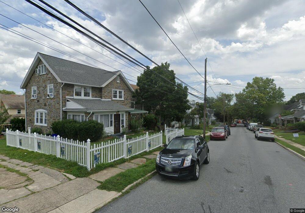
7117 Hazel Ave Upper Darby, PA 19082
Estimated Value: $384,000 - $455,000
4
Beds
2
Baths
2,257
Sq Ft
$179/Sq Ft
Est. Value
About This Home
This home is located at 7117 Hazel Ave, Upper Darby, PA 19082 and is currently estimated at $403,522, approximately $178 per square foot. 7117 Hazel Ave is a home located in Delaware County with nearby schools including Drexel Hill Middle School, Upper Darby High School, and St. Laurence's School.
Ownership History
Date
Name
Owned For
Owner Type
Purchase Details
Closed on
May 2, 2012
Sold by
Shad Farah Anila
Bought by
Shad Emmanuel and Shad Clara Rahila
Current Estimated Value
Purchase Details
Closed on
Dec 24, 2010
Sold by
Forney Andre M and Forney Rhonda
Bought by
Shad Farah Anila
Home Financials for this Owner
Home Financials are based on the most recent Mortgage that was taken out on this home.
Original Mortgage
$107,025
Interest Rate
4.88%
Mortgage Type
FHA
Purchase Details
Closed on
Jul 24, 1997
Sold by
Bezjian Marietta and Tovmassian Marietta Bezjian
Bought by
Forney Andre M and Forney Rhonda
Home Financials for this Owner
Home Financials are based on the most recent Mortgage that was taken out on this home.
Original Mortgage
$96,000
Interest Rate
7.5%
Create a Home Valuation Report for This Property
The Home Valuation Report is an in-depth analysis detailing your home's value as well as a comparison with similar homes in the area
Home Values in the Area
Average Home Value in this Area
Purchase History
| Date | Buyer | Sale Price | Title Company |
|---|---|---|---|
| Shad Emmanuel | -- | None Available | |
| Shad Farah Anila | $109,000 | None Available | |
| Forney Andre M | $108,000 | -- |
Source: Public Records
Mortgage History
| Date | Status | Borrower | Loan Amount |
|---|---|---|---|
| Previous Owner | Shad Farah Anila | $107,025 | |
| Previous Owner | Forney Andre M | $96,000 |
Source: Public Records
Tax History Compared to Growth
Tax History
| Year | Tax Paid | Tax Assessment Tax Assessment Total Assessment is a certain percentage of the fair market value that is determined by local assessors to be the total taxable value of land and additions on the property. | Land | Improvement |
|---|---|---|---|---|
| 2025 | $8,096 | $191,440 | $42,000 | $149,440 |
| 2024 | $8,096 | $191,440 | $42,000 | $149,440 |
| 2023 | $8,020 | $191,440 | $42,000 | $149,440 |
| 2022 | $7,804 | $191,440 | $42,000 | $149,440 |
| 2021 | $10,523 | $191,440 | $42,000 | $149,440 |
| 2020 | $7,127 | $110,180 | $30,190 | $79,990 |
| 2019 | $7,002 | $110,180 | $30,190 | $79,990 |
| 2018 | $6,921 | $110,180 | $0 | $0 |
| 2017 | $6,741 | $110,180 | $0 | $0 |
| 2016 | $605 | $110,180 | $0 | $0 |
| 2015 | $617 | $110,180 | $0 | $0 |
| 2014 | $605 | $110,180 | $0 | $0 |
Source: Public Records
Map
Nearby Homes
- 7011 Hazel Ave
- 7226 Penarth Ave
- 1434 Bywood Ave
- 362 Margate Rd
- 367 Margate Rd
- 207 Berbro Ave
- 318 Margate Rd
- 312 Bayard Rd
- 46 S State Rd
- 512 Fairfield Ave
- 7409 Miller Ave
- 107 S Keystone Ave
- 9 Berbro Ave
- 18 Elm Ave
- 244 Wembly Rd
- 7269 Walnut St
- 212 Huntley Rd
- 7920 W Chester Pike
- 127 Sherbrook Blvd
- 1806 Garrett Rd
- 7115 Hazel Ave
- 7119 Hazel Ave
- 7116 Penarth Ave
- 7118 Penarth Ave
- 7114 Penarth Ave
- 7113 Hazel Ave
- 7120 Penarth Ave
- 7123 Hazel Ave
- 7116 Hazel Ave
- 7112 Penarth Ave
- 7118 Hazel Ave
- 7114 Hazel Ave
- 7111 Hazel Ave
- 7120 Hazel Ave
- 7112 Hazel Ave
- 7122 Penarth Ave
- 7110 Penarth Ave
- 7125 Hazel Ave
- 7122 Hazel Ave
- 7110 Hazel Ave