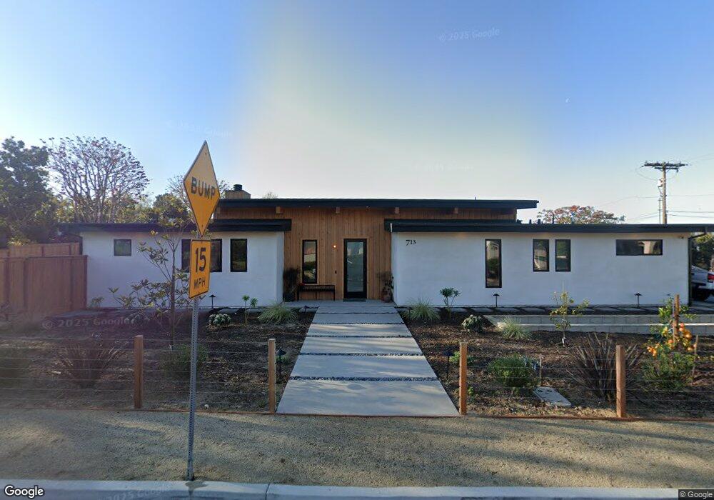
713 Normandy Rd Encinitas, CA 92024
Leucadia NeighborhoodEstimated Value: $2,088,000 - $2,860,000
4
Beds
3
Baths
2,518
Sq Ft
$999/Sq Ft
Est. Value
About This Home
This home is located at 713 Normandy Rd, Encinitas, CA 92024 and is currently estimated at $2,516,306, approximately $999 per square foot. 713 Normandy Rd is a home with nearby schools including Capri Elementary School, Diegueno Middle School, and La Costa Canyon High School.
Ownership History
Date
Name
Owned For
Owner Type
Purchase Details
Closed on
Oct 23, 2024
Sold by
Weir Robert and Weir Christina
Bought by
Weir Family Trust and Weir
Current Estimated Value
Purchase Details
Closed on
Mar 4, 2021
Sold by
Miller Douglas and Miller Cameron
Bought by
Weir Robert and Weir Christina
Purchase Details
Closed on
Oct 17, 2018
Sold by
Nee Eric C
Bought by
Miller Douglas and Miller Cameron
Purchase Details
Closed on
Jun 23, 2000
Sold by
Nee Thomas B and Nee Mary L
Bought by
Nee Thomas B and Nee Mary L
Create a Home Valuation Report for This Property
The Home Valuation Report is an in-depth analysis detailing your home's value as well as a comparison with similar homes in the area
Home Values in the Area
Average Home Value in this Area
Purchase History
| Date | Buyer | Sale Price | Title Company |
|---|---|---|---|
| Weir Family Trust | -- | None Listed On Document | |
| Weir Robert | $726,500 | Fidelity Natl Ttl San Diego | |
| Miller Douglas | $600,000 | Fidelity National Title | |
| Nee Thomas B | -- | -- |
Source: Public Records
Tax History
| Year | Tax Paid | Tax Assessment Tax Assessment Total Assessment is a certain percentage of the fair market value that is determined by local assessors to be the total taxable value of land and additions on the property. | Land | Improvement |
|---|---|---|---|---|
| 2025 | $10,648 | $1,469,650 | $786,250 | $683,400 |
| 2024 | $10,648 | $953,834 | $770,834 | $183,000 |
| 2023 | $8,454 | $755,720 | $755,720 | $0 |
| 2022 | $7,839 | $740,902 | $740,902 | $0 |
| 2021 | $6,594 | $618,340 | $618,340 | $0 |
| 2020 | $6,511 | $612,000 | $612,000 | $0 |
| 2019 | $6,376 | $600,000 | $600,000 | $0 |
| 2018 | $245 | $20,687 | $20,687 | $0 |
| 2017 | $241 | $20,282 | $20,282 | $0 |
| 2016 | $234 | $19,885 | $19,885 | $0 |
| 2015 | $231 | $19,587 | $19,587 | $0 |
| 2014 | $227 | $19,204 | $19,204 | $0 |
Source: Public Records
Map
Nearby Homes
- 712 Normandy Rd
- 817 Dolphin Cir
- 1129 31 Saxony Rd
- 1139 41 Saxony Rd
- 1068 Passiflora Ave
- 0 Fulvia St Unit NDP2505418
- 844 Saxony Rd
- 374 Fulvia St
- 697 Ocean View Ave
- 1355 Rainbow Ridge Ln
- 251 E Glaucus St
- 803 Saxony Rd
- 630 Poinsettia Park N
- 806 Hygeia Ave
- 698 Hygeia Ave
- 614 Ocean View Ave
- 1460 Orpheus Ave
- 1502 Christine Place Unit 1
- 699 N Vulcan Ave Unit 17
- 699 N Vulcan Ave Unit 133
- 605 Normandy Rd
- 698 Normandy Rd
- 684 Normandy Rd
- 729 Normandy Rd
- 1097 Normandy Hill Ln
- 1093 Normandy Hill Ln
- 1089 Normandy Hill Ln
- 670 Normandy Rd
- 701 Blossom Rd
- 1080 Normandy Hill Ln
- 687 Blossom Rd
- 1085 Normandy Hill Ln
- 927 Moonstone Ct
- 726 Normandy Rd
- 656 Normandy Rd
- 765 Normandy Rd
- 1081 Normandy Hill Ln
- 729 Blossom Rd
- 1076 Normandy Hill Ln
- 673 Blossom Rd
Your Personal Tour Guide
Ask me questions while you tour the home.