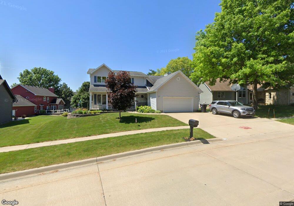
715 Fireside Dr Cedar Falls, IA 50613
Estimated Value: $353,000 - $440,000
4
Beds
5
Baths
2,421
Sq Ft
$163/Sq Ft
Est. Value
About This Home
This home is located at 715 Fireside Dr, Cedar Falls, IA 50613 and is currently estimated at $394,122, approximately $162 per square foot. 715 Fireside Dr is a home located in Black Hawk County with nearby schools including Helen A. Hansen Elementary School, Holmes Junior High School, and Cedar Falls High School.
Ownership History
Date
Name
Owned For
Owner Type
Purchase Details
Closed on
Mar 29, 2013
Sold by
Kestner Terry L and Kestner Diane L
Bought by
Kestner Terry L and Kestner Diane L
Current Estimated Value
Purchase Details
Closed on
May 1, 2007
Sold by
Hancock James K and Hancock Kimi D
Bought by
Kestner Terry L
Home Financials for this Owner
Home Financials are based on the most recent Mortgage that was taken out on this home.
Original Mortgage
$194,000
Outstanding Balance
$117,039
Interest Rate
6.2%
Mortgage Type
New Conventional
Estimated Equity
$277,083
Create a Home Valuation Report for This Property
The Home Valuation Report is an in-depth analysis detailing your home's value as well as a comparison with similar homes in the area
Home Values in the Area
Average Home Value in this Area
Purchase History
| Date | Buyer | Sale Price | Title Company |
|---|---|---|---|
| Kestner Terry L | -- | None Available | |
| Kestner Terry L | $242,500 | None Available |
Source: Public Records
Mortgage History
| Date | Status | Borrower | Loan Amount |
|---|---|---|---|
| Open | Kestner Terry L | $194,000 |
Source: Public Records
Tax History
| Year | Tax Paid | Tax Assessment Tax Assessment Total Assessment is a certain percentage of the fair market value that is determined by local assessors to be the total taxable value of land and additions on the property. | Land | Improvement |
|---|---|---|---|---|
| 2025 | $5,140 | $361,660 | $52,520 | $309,140 |
| 2024 | $5,140 | $329,650 | $52,520 | $277,130 |
| 2023 | $5,346 | $329,650 | $52,520 | $277,130 |
| 2022 | $5,408 | $298,460 | $52,520 | $245,940 |
| 2021 | $5,004 | $298,460 | $52,520 | $245,940 |
| 2020 | $4,888 | $276,660 | $35,010 | $241,650 |
| 2019 | $4,888 | $276,660 | $35,010 | $241,650 |
| 2018 | $4,418 | $247,830 | $35,010 | $212,820 |
| 2017 | $4,518 | $247,830 | $35,010 | $212,820 |
| 2016 | $4,226 | $247,830 | $35,010 | $212,820 |
| 2015 | $4,226 | $247,830 | $35,010 | $212,820 |
| 2014 | $4,274 | $247,830 | $35,010 | $212,820 |
Source: Public Records
Map
Nearby Homes
- 929 Barnett Dr
- 2718 Ryan Dr
- 1103 Carriage Ln
- 1033 Barrington Dr
- 2912 W 4th St Unit 2
- 114 Parkgate Rd
- 1522 W 5th St
- 1504 W 4th St
- 3702 Apollo St
- 1916 Shelden Ave
- 0 W 1st St
- 3023 Wellington Dr
- 502 Oak Park Blvd
- 3413 Pheasant Dr
- 1409 Parkway Ave
- 214 N Francis St
- 1115 Oak Park Blvd
- 2706 Country Meadow Ln
- 4035 Broomfield Dr
- 1826 Breckenridge St
- 709 Fireside Dr
- 721 Fireside Dr
- 721 Birdsall Dr
- 814 Barnett Dr
- 808 Barnett Dr
- 703 Fireside Dr
- 809 Birdsall Dr
- 718 Fireside Dr
- 706 Fireside Dr
- 708 Birdsall Dr
- 702 Birdsall Dr
- 802 Barnett Dr
- 627 Fireside Dr
- 716 Birdsall Dr
- 624 Fireside Dr
- 634 Birdsall Dr
- 712 Barnett Dr
- 619 Birdsall Dr
- 809 Barnett Dr
- 621 Fireside Dr
Your Personal Tour Guide
Ask me questions while you tour the home.