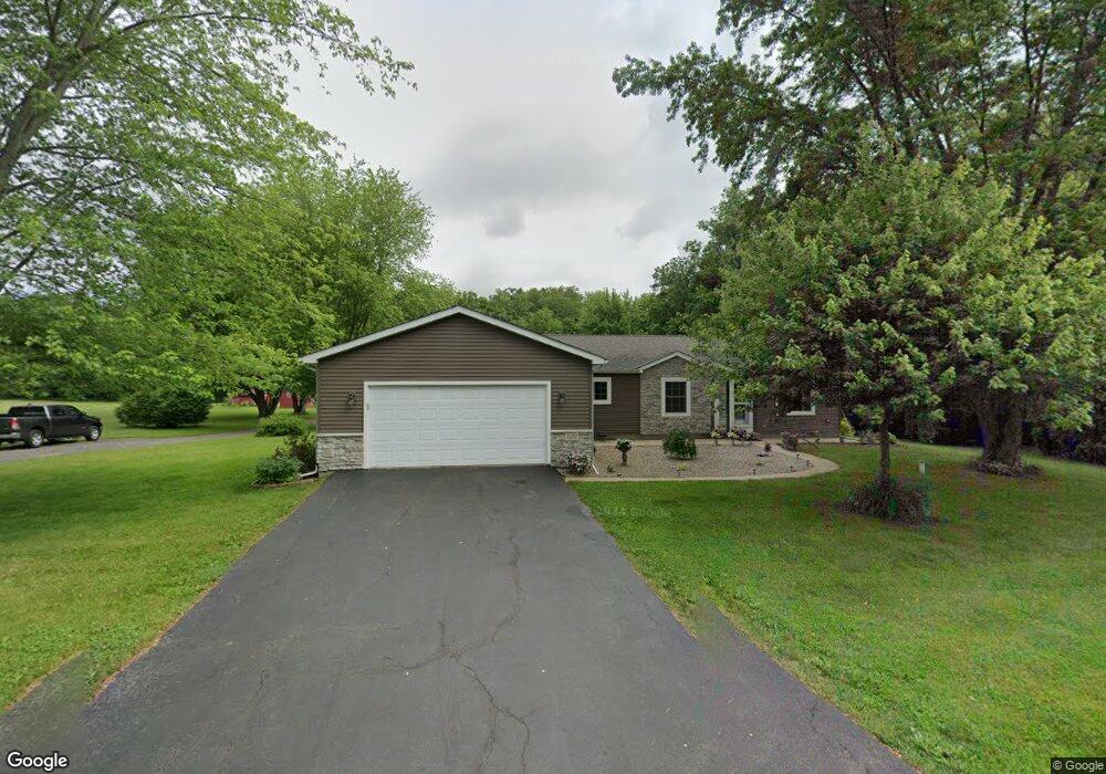
7177 W 1250 S Wanatah, IN 46390
Estimated Value: $302,165 - $334,000
4
Beds
2
Baths
1,664
Sq Ft
$191/Sq Ft
Est. Value
About This Home
This home is located at 7177 W 1250 S, Wanatah, IN 46390 and is currently estimated at $318,041, approximately $191 per square foot. 7177 W 1250 S is a home located in LaPorte County.
Ownership History
Date
Name
Owned For
Owner Type
Purchase Details
Closed on
Jan 22, 2024
Sold by
Froedge Michael H
Bought by
Froedge Michael H and Froedge Angela S
Current Estimated Value
Purchase Details
Closed on
Mar 7, 2022
Sold by
Patti Froedge
Bought by
Froedge Michael H
Home Financials for this Owner
Home Financials are based on the most recent Mortgage that was taken out on this home.
Original Mortgage
$160,500
Interest Rate
3.92%
Mortgage Type
New Conventional
Create a Home Valuation Report for This Property
The Home Valuation Report is an in-depth analysis detailing your home's value as well as a comparison with similar homes in the area
Home Values in the Area
Average Home Value in this Area
Purchase History
| Date | Buyer | Sale Price | Title Company |
|---|---|---|---|
| Froedge Michael H | -- | None Listed On Document | |
| Froedge Michael H | -- | Fidelity National Title |
Source: Public Records
Mortgage History
| Date | Status | Borrower | Loan Amount |
|---|---|---|---|
| Previous Owner | Froedge Michael H | $160,500 |
Source: Public Records
Tax History Compared to Growth
Tax History
| Year | Tax Paid | Tax Assessment Tax Assessment Total Assessment is a certain percentage of the fair market value that is determined by local assessors to be the total taxable value of land and additions on the property. | Land | Improvement |
|---|---|---|---|---|
| 2024 | $1,088 | $226,000 | $50,000 | $176,000 |
| 2023 | $1,009 | $153,900 | $37,500 | $116,400 |
| 2022 | $1,081 | $155,700 | $37,500 | $118,200 |
| 2021 | $1,059 | $147,200 | $37,500 | $109,700 |
| 2020 | $1,008 | $147,200 | $37,500 | $109,700 |
| 2019 | $937 | $141,700 | $33,500 | $108,200 |
| 2018 | $932 | $142,900 | $33,500 | $109,400 |
| 2017 | $860 | $139,300 | $33,500 | $105,800 |
| 2016 | $788 | $133,700 | $33,500 | $100,200 |
| 2014 | $686 | $125,700 | $33,500 | $92,200 |
Source: Public Records
Map
Nearby Homes
- 6465 W 1100 S
- 0 W Hwy 30 Unit GNR545374
- 307 N Pennsylvania St
- 627 Fieldcrest Cir
- 305 N Ohio St
- 116 Sprunger Dr
- 114 E Jersey St
- 104 W Cross St
- 106 N Illinois St Unit 266
- 105 Earl St
- 207 N Washington St
- 14501 S 400 W
- 9552 S Bigelow Mill Rd
- W 800 S V L
- 6948 W 1700 S
- 11333 S State Road 39
- 104 N Cummings St
- 210 Union St
- 627 E 300 S
- 7052 Long Ln