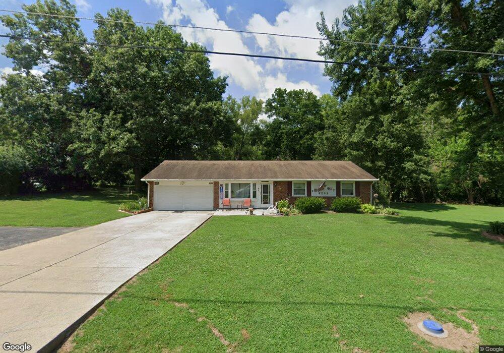
7191 Randall Rd Franklin, OH 45005
Estimated Value: $259,225 - $285,000
3
Beds
2
Baths
1,653
Sq Ft
$162/Sq Ft
Est. Value
About This Home
This home is located at 7191 Randall Rd, Franklin, OH 45005 and is currently estimated at $268,056, approximately $162 per square foot. 7191 Randall Rd is a home located in Warren County with nearby schools including Franklin High School.
Ownership History
Date
Name
Owned For
Owner Type
Purchase Details
Closed on
Jul 8, 2005
Sold by
Walker Irene and Irene Walker Trust
Bought by
Webb Michael A and Webb Teresa M
Current Estimated Value
Home Financials for this Owner
Home Financials are based on the most recent Mortgage that was taken out on this home.
Original Mortgage
$123,200
Outstanding Balance
$59,508
Interest Rate
5%
Mortgage Type
New Conventional
Estimated Equity
$208,548
Purchase Details
Closed on
Jul 2, 1993
Sold by
Ferrell Joan K and Ferrell Joan K
Bought by
Walker and Walker Irene
Purchase Details
Closed on
Nov 24, 1992
Sold by
Ferrell Ferrell and Ferrell Robert E
Bought by
Ferrell Ferrell and Ferrell Joan K
Purchase Details
Closed on
Apr 3, 1990
Sold by
Erbaugh Erbaugh and Erbaugh Michael D
Bought by
Ferrell Ferrell and Ferrell Robert E
Purchase Details
Closed on
Oct 31, 1984
Sold by
Elam Elam and Elam James D
Bought by
Erbaugh Erbaugh and Erbaugh Michael D
Create a Home Valuation Report for This Property
The Home Valuation Report is an in-depth analysis detailing your home's value as well as a comparison with similar homes in the area
Home Values in the Area
Average Home Value in this Area
Purchase History
| Date | Buyer | Sale Price | Title Company |
|---|---|---|---|
| Webb Michael A | $154,000 | Lawyers Title | |
| Walker | $90,000 | -- | |
| Ferrell Ferrell | -- | -- | |
| Ferrell Ferrell | $80,000 | -- | |
| Erbaugh Erbaugh | $68,000 | -- |
Source: Public Records
Mortgage History
| Date | Status | Borrower | Loan Amount |
|---|---|---|---|
| Open | Webb Michael A | $123,200 | |
| Closed | Webb Michael A | $30,800 |
Source: Public Records
Tax History
| Year | Tax Paid | Tax Assessment Tax Assessment Total Assessment is a certain percentage of the fair market value that is determined by local assessors to be the total taxable value of land and additions on the property. | Land | Improvement |
|---|---|---|---|---|
| 2025 | $3,126 | $70,930 | $20,100 | $50,830 |
| 2024 | $3,126 | $70,930 | $20,100 | $50,830 |
| 2023 | $2,666 | $54,442 | $12,617 | $41,825 |
| 2022 | $2,607 | $54,443 | $12,618 | $41,825 |
| 2021 | $2,462 | $54,443 | $12,618 | $41,825 |
| 2020 | $2,475 | $48,178 | $11,165 | $37,013 |
| 2019 | $2,236 | $48,178 | $11,165 | $37,013 |
| 2018 | $2,229 | $48,178 | $11,165 | $37,013 |
| 2017 | $2,210 | $43,288 | $10,182 | $33,107 |
| 2016 | $2,257 | $43,288 | $10,182 | $33,107 |
| 2015 | $2,258 | $43,288 | $10,182 | $33,107 |
| 2014 | $2,314 | $43,290 | $10,180 | $33,110 |
| 2013 | $1,966 | $47,470 | $11,170 | $36,300 |
Source: Public Records
Map
Nearby Homes
- 0 Kathy Ln Unit 1834240
- 0 Kathy Ln Unit 930066
- 7189 Shaker Rd
- 218 Roberts Ave
- 5684 Olive Rd
- 139 E 6th St
- 1200 Riley Blvd
- 388 Thomas Dr
- 1117 S Main St
- 627 S River St
- 0 E 4th St
- 202 E 2nd St
- 6323 Shaker Rd
- 409 Millard Dr
- 760 David Blvd
- 747 David Blvd
- 210 N Riley Blvd
- 309 Oxford Rd
- 995 E 4th St
- 551 E 2nd St
- 7169 Randall Rd
- 7208 Randall Rd
- 7188 Randall Rd
- 7151 Randall Rd
- 7166 Randall Rd
- 7242 Randall Rd
- 5353 Tama Ln
- 7133 Randall Rd
- 7148 Randall Rd
- 7279 State Route 123
- 7259 State Route 123
- 7299 State Route 123
- 5371 Tama Ln
- 7239 State Route 123
- 7130 Randall Rd
- 7319 State Route 123
- 7239 Ohio 123
- 7057 Howard Rd
- 7089 Howard Rd
- 7207 State Route 123
Your Personal Tour Guide
Ask me questions while you tour the home.