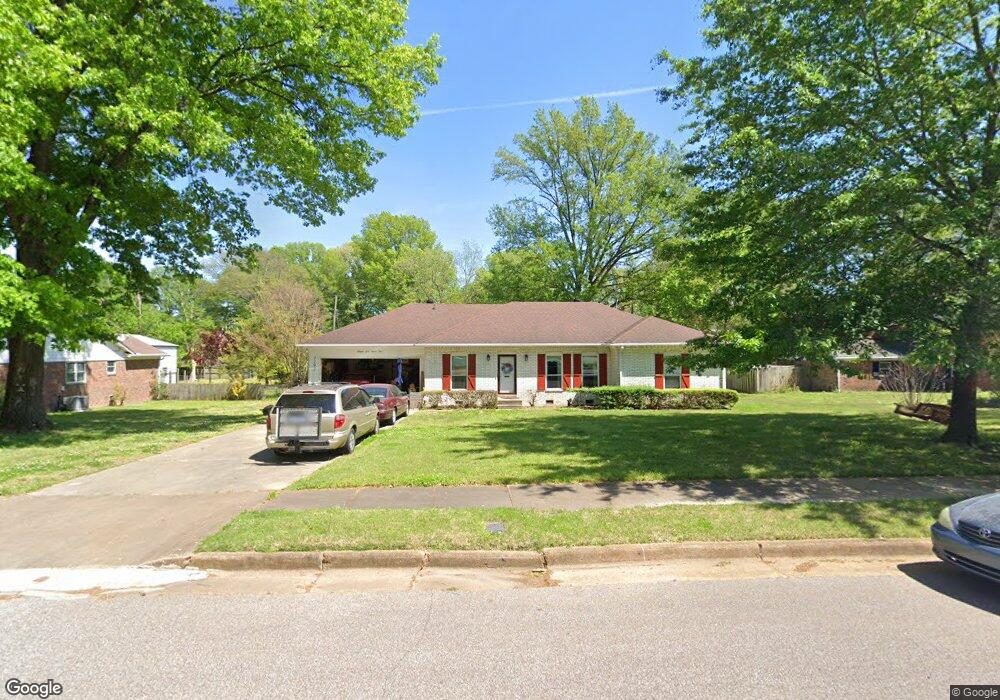
7192 Baker St Millington, TN 38053
Estimated Value: $305,000 - $352,000
4
Beds
3
Baths
2,622
Sq Ft
$125/Sq Ft
Est. Value
About This Home
This home is located at 7192 Baker St, Millington, TN 38053 and is currently estimated at $327,303, approximately $124 per square foot. 7192 Baker St is a home located in Shelby County with nearby schools including Millington Elementary School, Millington High School, and Woodlawn Baptist Academy.
Ownership History
Date
Name
Owned For
Owner Type
Purchase Details
Closed on
May 3, 2005
Sold by
Biggs Lodie V and Biggs Martha M
Bought by
Lanza Paul K and Lanza Marjean E
Current Estimated Value
Home Financials for this Owner
Home Financials are based on the most recent Mortgage that was taken out on this home.
Original Mortgage
$144,000
Outstanding Balance
$75,757
Interest Rate
5.98%
Mortgage Type
Fannie Mae Freddie Mac
Estimated Equity
$251,546
Create a Home Valuation Report for This Property
The Home Valuation Report is an in-depth analysis detailing your home's value as well as a comparison with similar homes in the area
Home Values in the Area
Average Home Value in this Area
Purchase History
| Date | Buyer | Sale Price | Title Company |
|---|---|---|---|
| Lanza Paul K | $180,000 | -- |
Source: Public Records
Mortgage History
| Date | Status | Borrower | Loan Amount |
|---|---|---|---|
| Open | Lanza Paul K | $144,000 |
Source: Public Records
Tax History Compared to Growth
Tax History
| Year | Tax Paid | Tax Assessment Tax Assessment Total Assessment is a certain percentage of the fair market value that is determined by local assessors to be the total taxable value of land and additions on the property. | Land | Improvement |
|---|---|---|---|---|
| 2025 | $3,768 | $79,875 | $7,350 | $72,525 |
| 2024 | $3,768 | $55,575 | $6,100 | $49,475 |
| 2023 | $2,662 | $55,575 | $6,100 | $49,475 |
| 2022 | $2,662 | $55,575 | $6,100 | $49,475 |
| 2021 | $2,695 | $55,575 | $6,100 | $49,475 |
| 2020 | $2,259 | $40,475 | $5,825 | $34,650 |
| 2019 | $1,639 | $40,475 | $5,825 | $34,650 |
| 2018 | $2,259 | $40,475 | $5,825 | $34,650 |
| 2017 | $2,283 | $40,475 | $5,825 | $34,650 |
| 2016 | $2,356 | $39,925 | $0 | $0 |
| 2014 | $1,745 | $39,925 | $0 | $0 |
Source: Public Records
Map
Nearby Homes
- 7202 Renda St
- 7163 Pam Dr
- 4917 Hallbrook Dr
- KERRY Plan at Riggs Pointe
- Cali Plan at Riggs Pointe
- Aria Plan at Riggs Pointe
- 7206 Juana Dr
- 7011 Alder Wood Dr
- 7266 Raleigh Millington Rd
- 4315 Peach Run Lane Ln
- 4325 Peach Run Lane Ln
- 4310 Peach Run Lane Ln
- 4703 Cedar Rose Dr
- 4321 Peach Run Ln
- 4306 Peach Run Ln
- 4302 Peach Run Lane Ln
- 4288 Peach Run Lane Ln
- 4537 Basun Cir S
- 4531 Basun Cir S
- 4527 Basun Cir S
- 7180 Baker St
- 7202 Baker St
- 7185 Renda St
- 7175 Renda St
- 4816 Hallbrook Dr
- 7195 Renda St
- 7165 Renda St
- 7166 Baker St
- 7216 Baker St
- 4851 Waycross Ave
- 7207 Baker St
- 4815 Hallbrook Dr
- 7153 Renda St
- 4804 Hallbrook Dr
- 7217 Baker St
- 0 Big Creek Church Rd Unit 3128176
- 0 Big Creek Church Rd Unit 3128172
- 0 Big Creek Church Rd Unit 3161229
- 0 Big Creek Church Rd Unit 9998222
- 4803 Hallbrook Dr