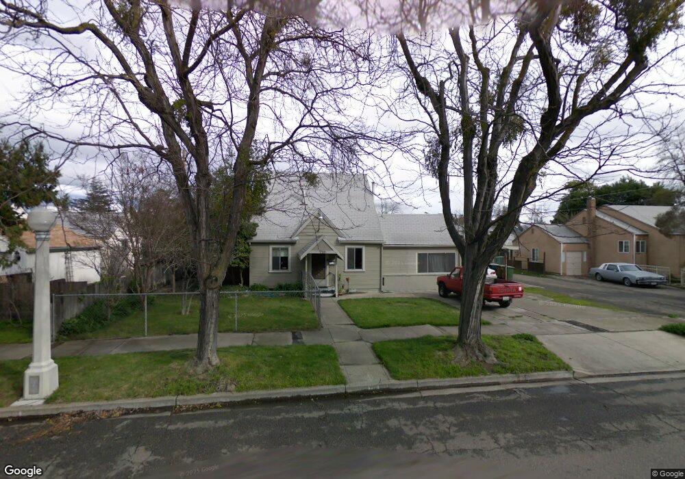
720 Lincoln Ave Lodi, CA 95240
North Lodi NeighborhoodEstimated Value: $386,000 - $542,083
4
Beds
3
Baths
2,394
Sq Ft
$192/Sq Ft
Est. Value
About This Home
This home is located at 720 Lincoln Ave, Lodi, CA 95240 and is currently estimated at $460,271, approximately $192 per square foot. 720 Lincoln Ave is a home located in San Joaquin County with nearby schools including Lakewood Elementary School, Millswood Middle School, and Lodi High School.
Ownership History
Date
Name
Owned For
Owner Type
Purchase Details
Closed on
May 12, 2011
Sold by
Aurora Loan Services Llc
Bought by
Khan Zulfiqar
Current Estimated Value
Purchase Details
Closed on
Oct 28, 2010
Sold by
Major Kenneth H
Bought by
Aurora Loan Services Llc
Purchase Details
Closed on
Oct 12, 2006
Sold by
Major Kenneth H
Bought by
Major Kenneth H and Major Diane
Purchase Details
Closed on
Sep 9, 2004
Sold by
Heisler Kay Marie
Bought by
Major Kenneth H
Home Financials for this Owner
Home Financials are based on the most recent Mortgage that was taken out on this home.
Original Mortgage
$211,200
Interest Rate
5.37%
Mortgage Type
Purchase Money Mortgage
Create a Home Valuation Report for This Property
The Home Valuation Report is an in-depth analysis detailing your home's value as well as a comparison with similar homes in the area
Home Values in the Area
Average Home Value in this Area
Purchase History
| Date | Buyer | Sale Price | Title Company |
|---|---|---|---|
| Khan Zulfiqar | $67,000 | North American Title Company | |
| Aurora Loan Services Llc | $205,000 | Accommodation | |
| Major Kenneth H | -- | None Available | |
| Major Kenneth H | $264,000 | Commonwealth Title Co | |
| Major Kenneth H | -- | Commonwealth Title Co |
Source: Public Records
Mortgage History
| Date | Status | Borrower | Loan Amount |
|---|---|---|---|
| Previous Owner | Major Kenneth H | $211,200 |
Source: Public Records
Tax History
| Year | Tax Paid | Tax Assessment Tax Assessment Total Assessment is a certain percentage of the fair market value that is determined by local assessors to be the total taxable value of land and additions on the property. | Land | Improvement |
|---|---|---|---|---|
| 2025 | $954 | $85,829 | $20,495 | $65,334 |
| 2024 | $928 | $84,147 | $20,094 | $64,053 |
| 2023 | $909 | $82,498 | $19,700 | $62,798 |
| 2022 | $888 | $80,881 | $19,314 | $61,567 |
| 2021 | $904 | $79,296 | $18,936 | $60,360 |
| 2020 | $881 | $78,484 | $18,742 | $59,742 |
| 2019 | $864 | $76,946 | $18,375 | $58,571 |
| 2018 | $852 | $75,438 | $18,015 | $57,423 |
| 2017 | $833 | $73,960 | $17,662 | $56,298 |
| 2016 | $781 | $72,511 | $17,316 | $55,195 |
| 2015 | $773 | $71,422 | $17,056 | $54,366 |
| 2014 | $764 | $70,023 | $16,722 | $53,301 |
Source: Public Records
Map
Nearby Homes
- 421 Daisy Ave
- 610 N California St
- 216 Eureka Ave
- 416 Daisy Ave
- 322 W Turner Rd
- 518 N Church St
- 606 W Turner Rd
- 625 N Sacramento St
- 833 Holly Dr
- 0 W Turner Rd Unit 226006338
- 333 W Locust St
- 101 W Lockeford St
- 1258 Rivergate Dr
- 507 N Sunset Dr
- 521 W Pine St
- 418 Gerard Dr
- 400 N Pacific Ave
- 909 Greenwood Dr
- 1729 Le Bec Ct
- 1416 Reiman St
- 712 Lincoln Ave
- 332 Louie Ave
- 336 Louie Ave
- 340 Louie Ave
- 328 Louie Ave
- 708 Lincoln Ave
- 721 Lincoln Ave
- 331 Forrest Ave
- 725 Lincoln Ave
- 715 Lincoln Ave
- 324 1/2 Louie Ave
- 324 Louie Ave
- 325 Forrest Ave
- 400 Louie Ave
- 321 Forrest Ave Unit 1/2
- 321 Forrest Ave
- 321 Forrest Ave
- 343 Forrest Ave
- 337 Forrest Ave
- 401 Forrest Ave
Your Personal Tour Guide
Ask me questions while you tour the home.