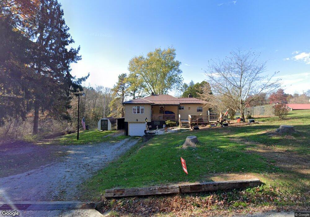
721 Bunker Hill Rd Kittanning, PA 16201
North Buffalo Township NeighborhoodEstimated Value: $150,000 - $236,000
3
Beds
1
Bath
984
Sq Ft
$184/Sq Ft
Est. Value
About This Home
This home is located at 721 Bunker Hill Rd, Kittanning, PA 16201 and is currently estimated at $180,738, approximately $183 per square foot. 721 Bunker Hill Rd is a home with nearby schools including West Hills Intermediate School, West Hills Primary School, and Grace Christian School.
Ownership History
Date
Name
Owned For
Owner Type
Purchase Details
Closed on
Jan 29, 2022
Sold by
Ion Brenda L
Bought by
Ion Brenda L
Current Estimated Value
Purchase Details
Closed on
Jun 13, 2005
Sold by
Legersky Daniel J and Legersky Brenda L
Bought by
Ion Brendon L and Ion Donald F
Home Financials for this Owner
Home Financials are based on the most recent Mortgage that was taken out on this home.
Original Mortgage
$64,000
Interest Rate
5.82%
Mortgage Type
New Conventional
Purchase Details
Closed on
Apr 24, 1997
Bought by
Edwards Alex R and Edwards Mary K
Create a Home Valuation Report for This Property
The Home Valuation Report is an in-depth analysis detailing your home's value as well as a comparison with similar homes in the area
Home Values in the Area
Average Home Value in this Area
Purchase History
| Date | Buyer | Sale Price | Title Company |
|---|---|---|---|
| Ion Brenda L | -- | Calarie Cindy L | |
| Ion Brendon L | -- | None Available | |
| Edwards Alex R | $53,000 | -- |
Source: Public Records
Mortgage History
| Date | Status | Borrower | Loan Amount |
|---|---|---|---|
| Previous Owner | Ion Brendon L | $64,000 |
Source: Public Records
Tax History Compared to Growth
Tax History
| Year | Tax Paid | Tax Assessment Tax Assessment Total Assessment is a certain percentage of the fair market value that is determined by local assessors to be the total taxable value of land and additions on the property. | Land | Improvement |
|---|---|---|---|---|
| 2025 | $3,098 | $34,870 | $21,020 | $13,850 |
| 2024 | $2,924 | $34,870 | $21,020 | $13,850 |
| 2023 | $2,518 | $34,870 | $21,020 | $13,850 |
| 2022 | $2,518 | $34,870 | $21,020 | $13,850 |
| 2021 | $2,488 | $34,870 | $21,020 | $13,850 |
| 2020 | $2,488 | $34,870 | $21,020 | $13,850 |
| 2019 | $2,488 | $34,870 | $21,020 | $13,850 |
| 2018 | $2,492 | $30,027 | $10,235 | $19,792 |
| 2017 | $2,474 | $34,870 | $21,020 | $13,850 |
| 2016 | $2,474 | $34,870 | $21,020 | $13,850 |
| 2015 | $1,856 | $34,870 | $21,020 | $13,850 |
| 2014 | $1,856 | $34,870 | $21,020 | $13,850 |
Source: Public Records
Map
Nearby Homes
- 208 Briar Hill Rd
- 217 Briar Hill Rd
- 728 Ferne Dr
- 711 S Harrison St
- 701 S Harrison St
- 514 Southern Ave
- 228 Arthur St
- 100 Mccain St
- 226 Ridge Ave
- 349 Franklin Ave
- 238 Allegheny Ave
- 1336 4th Ave Unit 1338
- 417 14th St
- 1234 4th Ave
- 1225 4th Ave
- 1039 Glade Park E
- 418 Pine Hill Rd
- 1239 6th Ave
- 1131 6th Ave
- 156 S Jefferson St
- 725 Bunker Hill Rd
- 782 Pony Farm Rd
- 772 Pony Farm Rd
- 741 Bunker Hill Rd
- 712 Bunker Hill Rd
- 709 Bunker Hill Rd
- 790 Pony Farm Rd
- 789 Pony Farm Rd
- 795 Pony Farm Rd
- 760 Pony Farm Rd
- 798 Pony Farm Rd
- 802 Pony Farm Rd
- 803 Pony Farm Rd
- 664 Bunker Hill Rd
- 690 Bunker Hill Rd
- 750 Pony Farm Rd
- 804 Pony Farm Rd
- 117 Windcrest Dr
- 110 Windcrest Dr
- 800 Pony Farm Rd