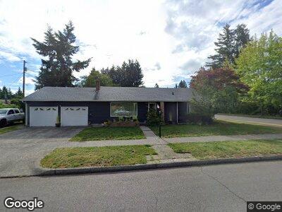
722 Decatur St SW Olympia, WA 98502
South Westside NeighborhoodEstimated Value: $452,597 - $547,000
2
Beds
1
Bath
1,973
Sq Ft
$249/Sq Ft
Est. Value
About This Home
This home is located at 722 Decatur St SW, Olympia, WA 98502 and is currently estimated at $491,149, approximately $248 per square foot. 722 Decatur St SW is a home located in Thurston County with nearby schools including Garfield Elementary School, Jefferson Middle School, and Capital High School.
Ownership History
Date
Name
Owned For
Owner Type
Purchase Details
Closed on
Feb 13, 2013
Sold by
Olson Jeffrey E and Olson Faye E
Bought by
Ray Christopher Gerald
Current Estimated Value
Create a Home Valuation Report for This Property
The Home Valuation Report is an in-depth analysis detailing your home's value as well as a comparison with similar homes in the area
Home Values in the Area
Average Home Value in this Area
Purchase History
| Date | Buyer | Sale Price | Title Company |
|---|---|---|---|
| Ray Christopher Gerald | -- | None Available |
Source: Public Records
Mortgage History
| Date | Status | Borrower | Loan Amount |
|---|---|---|---|
| Closed | Ray Christopher Gerald | $105,000 | |
| Closed | Ray Christopher G | $177,600 | |
| Closed | Ray Christopher G | $175,000 |
Source: Public Records
Tax History Compared to Growth
Tax History
| Year | Tax Paid | Tax Assessment Tax Assessment Total Assessment is a certain percentage of the fair market value that is determined by local assessors to be the total taxable value of land and additions on the property. | Land | Improvement |
|---|---|---|---|---|
| 2024 | $4,229 | $414,600 | $167,300 | $247,300 |
| 2023 | $4,229 | $404,100 | $140,100 | $264,000 |
| 2022 | $4,043 | $394,600 | $113,700 | $280,900 |
| 2021 | $3,486 | $338,200 | $102,600 | $235,600 |
| 2020 | $3,491 | $269,800 | $85,800 | $184,000 |
| 2019 | $3,092 | $263,600 | $74,700 | $188,900 |
| 2018 | $3,056 | $226,800 | $61,800 | $165,000 |
| 2017 | $2,583 | $206,450 | $70,650 | $135,800 |
| 2016 | $2,287 | $190,550 | $64,450 | $126,100 |
| 2014 | -- | $182,650 | $63,150 | $119,500 |
Source: Public Records
Map
Nearby Homes
- 819 Decatur St SW
- 1503 6th Ave SW
- 1304 7th Ave SW
- 2123 9th Ave SW
- 1121 4th Ave W
- 1214 11th Ct SW
- 124 Rogers St NW
- 2300 9th Ave SW Unit A7
- 2300 9th Ave SW Unit C6
- 1201 11th Ct SW
- 1220 Fern St SW
- 214 Sherman St NW
- 401 Division St NW
- 408 Plymouth St NW
- 2013 Bush Ave NW
- 2301 Bush Ave NW
- 1314 Evergreen Park Dr SW Unit D
- 1727 Conger Ave NW
- 303 Kenyon St NW Unit 1D
- 1917 Giles Ave NW
- 722 Decatur St SW
- 1604 8th Ave SW
- 1609 7th Ave SW
- 1522 8th Ave SW
- 1706 8th Ave SW
- 1603 7th Ave SW
- 721 Decatur St SW
- 1671 8th Ave SW
- 1514 8th Ave SW
- 1609 8th Ave SW
- 711 Decatur St SW
- 1521 7th Ave SW
- 1705 8th Ave SW
- 703 Decatur St SW
- 1675 7th Ave SW
- 1513 7th Ave SW
- 1525 8th Ave SW
- 812 Decatur St SW
- 807 Decatur St SW
- 1510 8th Ave SW