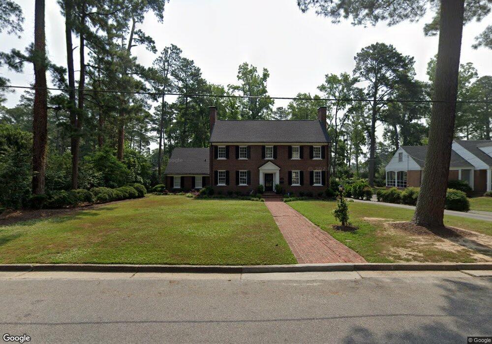
722 Jones St Suffolk, VA 23434
Holy Neck NeighborhoodEstimated Value: $612,000 - $722,000
3
Beds
3
Baths
3,312
Sq Ft
$204/Sq Ft
Est. Value
About This Home
This home is located at 722 Jones St, Suffolk, VA 23434 and is currently estimated at $675,374, approximately $203 per square foot. 722 Jones St is a home located in Suffolk City with nearby schools including Elephant's Fork Elementary School, King's Fork Middle School, and King's Fork High School.
Ownership History
Date
Name
Owned For
Owner Type
Purchase Details
Closed on
Jul 29, 2021
Sold by
Babb Robert W and Babb Sandra J
Bought by
Webb Jarratt B and Webb Emily A
Current Estimated Value
Home Financials for this Owner
Home Financials are based on the most recent Mortgage that was taken out on this home.
Original Mortgage
$290,000
Outstanding Balance
$262,402
Interest Rate
3%
Mortgage Type
New Conventional
Estimated Equity
$412,973
Create a Home Valuation Report for This Property
The Home Valuation Report is an in-depth analysis detailing your home's value as well as a comparison with similar homes in the area
Home Values in the Area
Average Home Value in this Area
Purchase History
| Date | Buyer | Sale Price | Title Company |
|---|---|---|---|
| Webb Jarratt B | $590,000 | Attorney |
Source: Public Records
Mortgage History
| Date | Status | Borrower | Loan Amount |
|---|---|---|---|
| Open | Webb Jarratt B | $290,000 |
Source: Public Records
Tax History
| Year | Tax Paid | Tax Assessment Tax Assessment Total Assessment is a certain percentage of the fair market value that is determined by local assessors to be the total taxable value of land and additions on the property. | Land | Improvement |
|---|---|---|---|---|
| 2025 | $7,558 | $664,300 | $96,400 | $567,900 |
| 2024 | $7,558 | $598,900 | $96,400 | $502,500 |
| 2023 | $6,801 | $612,500 | $96,400 | $516,100 |
| 2022 | $5,936 | $544,600 | $96,400 | $448,200 |
| 2021 | $4,565 | $411,300 | $87,600 | $323,700 |
| 2020 | $4,278 | $385,400 | $87,600 | $297,800 |
| 2019 | $4,278 | $385,400 | $87,600 | $297,800 |
| 2018 | $4,130 | $372,600 | $87,600 | $285,000 |
| 2017 | $3,854 | $360,200 | $87,600 | $272,600 |
| 2016 | $3,854 | $360,200 | $87,600 | $272,600 |
| 2015 | $1,883 | $360,200 | $87,600 | $272,600 |
| 2014 | $1,883 | $360,200 | $87,600 | $272,600 |
Source: Public Records
Map
Nearby Homes
- 611 Jones St
- 609 Jones St
- 506 Dumville Ave
- 315 W Constance Rd Unit 320
- 315 W Constance Rd Unit 232
- 139 Church St
- 107 Day St
- 126 Church St
- 136 Mahan St
- 134 Mahan St
- 655 3rd Ave
- 204 Bute St
- 207 Pitchkettle Rd
- 223 Clay St
- 132 Chestnut St
- 222 Clay St
- 129 Chestnut St
- 126 Chestnut St
- 124 Chestnut St
- 117 Bute St
Your Personal Tour Guide
Ask me questions while you tour the home.