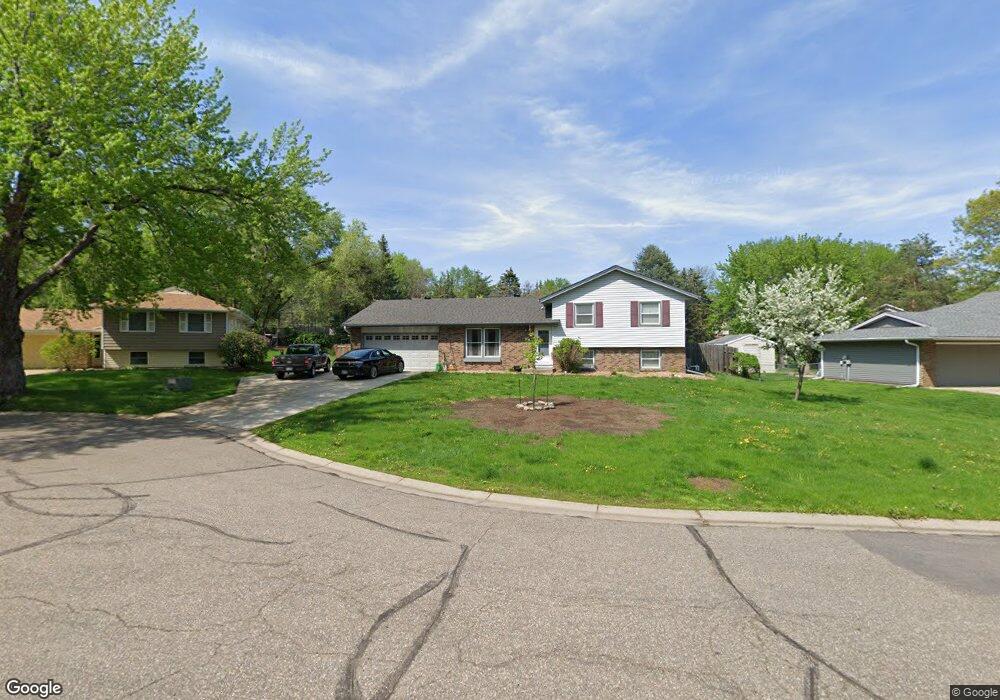
7225 144th Ct Saint Paul, MN 55124
Scott Highlands NeighborhoodEstimated Value: $386,000 - $395,437
3
Beds
2
Baths
1,072
Sq Ft
$365/Sq Ft
Est. Value
About This Home
This home is located at 7225 144th Ct, Saint Paul, MN 55124 and is currently estimated at $391,109, approximately $364 per square foot. 7225 144th Ct is a home located in Dakota County with nearby schools including Greenleaf Elementary School, Falcon Ridge Middle School, and Apple Valley Senior High School.
Ownership History
Date
Name
Owned For
Owner Type
Purchase Details
Closed on
Jun 30, 2016
Sold by
Bigham Arthur W and Bigham Barbara J
Bought by
Klesser Daryl L and Klesser Krissoula Rose
Current Estimated Value
Home Financials for this Owner
Home Financials are based on the most recent Mortgage that was taken out on this home.
Original Mortgage
$245,471
Outstanding Balance
$196,212
Interest Rate
3.62%
Mortgage Type
FHA
Estimated Equity
$194,897
Purchase Details
Closed on
Nov 20, 1998
Sold by
Ness Lynn A and Ness Kirsten K
Bought by
Bigham Ii Arthur W and Bigham Barbara J
Create a Home Valuation Report for This Property
The Home Valuation Report is an in-depth analysis detailing your home's value as well as a comparison with similar homes in the area
Home Values in the Area
Average Home Value in this Area
Purchase History
| Date | Buyer | Sale Price | Title Company |
|---|---|---|---|
| Klesser Daryl L | $259,800 | Burnet Title | |
| Bigham Ii Arthur W | $140,500 | -- |
Source: Public Records
Mortgage History
| Date | Status | Borrower | Loan Amount |
|---|---|---|---|
| Open | Klesser Daryl L | $245,471 |
Source: Public Records
Tax History Compared to Growth
Tax History
| Year | Tax Paid | Tax Assessment Tax Assessment Total Assessment is a certain percentage of the fair market value that is determined by local assessors to be the total taxable value of land and additions on the property. | Land | Improvement |
|---|---|---|---|---|
| 2024 | $3,966 | $349,700 | $97,300 | $252,400 |
| 2023 | $3,966 | $353,400 | $97,500 | $255,900 |
| 2022 | $3,154 | $338,300 | $97,200 | $241,100 |
| 2021 | $3,036 | $279,600 | $84,600 | $195,000 |
| 2020 | $3,048 | $264,400 | $80,600 | $183,800 |
| 2019 | $2,757 | $258,100 | $76,800 | $181,300 |
| 2018 | $2,579 | $245,700 | $73,100 | $172,600 |
| 2017 | $2,572 | $222,500 | $69,600 | $152,900 |
| 2016 | $2,625 | $211,800 | $66,300 | $145,500 |
| 2015 | $2,314 | $195,366 | $59,507 | $135,859 |
| 2014 | -- | $172,803 | $56,136 | $116,667 |
| 2013 | -- | $164,519 | $51,462 | $113,057 |
Source: Public Records
Map
Nearby Homes
- 14461 Freesia Way
- 14620 Garrett Ave Unit 310
- 14242 Glencove Trail
- 7662 142nd St W
- 7342 Upper 139th St W
- 14217 Footbridge Way
- 14440 Flax Way
- 13868 Glendale Ct
- 13720 Georgia Dr
- 7291 Upper 136th St W
- 14057 Flintwood Ct
- 13954 Flagstaff Ct
- 13947 Fleetwood Ave
- 7577 138th St W
- 14080 Guthrie Ave
- 13715 Grafton Ct
- 14786 Hallmark Dr
- 7070 153rd St W Unit 211
- 13660 Gurney Path
- 834 Fireside Dr
- 7199 144th Ct
- 14417 Garrett Ave
- 7243 144th Ct
- 7245 144th Ct
- 7218 144th Ct
- 7234 144th Ct
- 14405 Garrett Ave
- 14426 Garrett Ave
- 7200 144th Ct
- 7250 144th Ct
- 7188 144th Ct
- 14438 Garrett Ave
- 14414 Garrett Ave
- 14400 Garrett Ave
- 14393 Garrett Ave
- 14548 Genesee Ave
- 14560 Genesee Ave
- 14473 Garrett Ave
- 14540 Genesee Ave
- 7205 145th St W