Estimated Value: $420,099 - $457,000
3
Beds
2
Baths
1,304
Sq Ft
$336/Sq Ft
Est. Value
About This Home
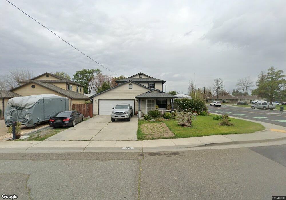
This home is located at 725 Simon St, Galt, CA 95632 and is currently estimated at $437,775, approximately $335 per square foot. 725 Simon St is a home located in Sacramento County with nearby schools including Marengo Ranch Elementary School, Robert L. McCaffrey Middle School, and Galt High School.
Ownership History
Date
Name
Owned For
Owner Type
Purchase Details
Closed on
Oct 14, 2009
Sold by
Sacramento Habitat For Humanity
Bought by
Caballero Adrian and Caballero Marissa
Current Estimated Value
Home Financials for this Owner
Home Financials are based on the most recent Mortgage that was taken out on this home.
Original Mortgage
$101,985
Outstanding Balance
$66,390
Interest Rate
5.02%
Mortgage Type
Purchase Money Mortgage
Estimated Equity
$371,385
Create a Home Valuation Report for This Property
The Home Valuation Report is an in-depth analysis detailing your home's value as well as a comparison with similar homes in the area
Home Values in the Area
Average Home Value in this Area
Purchase History
| Date | Buyer | Sale Price | Title Company |
|---|---|---|---|
| Caballero Adrian | $157,000 | Chicago Title Company |
Source: Public Records
Mortgage History
| Date | Status | Borrower | Loan Amount |
|---|---|---|---|
| Open | Caballero Adrian | $101,985 |
Source: Public Records
Tax History
| Year | Tax Paid | Tax Assessment Tax Assessment Total Assessment is a certain percentage of the fair market value that is determined by local assessors to be the total taxable value of land and additions on the property. | Land | Improvement |
|---|---|---|---|---|
| 2025 | $2,230 | $202,646 | $51,627 | $151,019 |
| 2024 | $2,230 | $198,673 | $50,615 | $148,058 |
| 2023 | $2,193 | $194,778 | $49,623 | $145,155 |
| 2022 | $2,104 | $190,959 | $48,650 | $142,309 |
| 2021 | $2,107 | $187,216 | $47,697 | $139,519 |
| 2020 | $2,089 | $185,297 | $47,208 | $138,089 |
| 2019 | $2,037 | $181,665 | $46,283 | $135,382 |
| 2018 | $2,034 | $178,104 | $45,376 | $132,728 |
| 2017 | $1,954 | $174,613 | $44,487 | $130,126 |
| 2016 | $1,878 | $171,190 | $43,615 | $127,575 |
| 2015 | $1,813 | $168,619 | $42,960 | $125,659 |
| 2014 | $1,809 | $165,317 | $42,119 | $123,198 |
Source: Public Records
Map
Nearby Homes
- 702 Elm Ave
- 10657 Simmerhorn Rd
- 216 Mcfarland St
- 604 Pringle Ave Unit 94
- 604 Pringle Ave Unit 1
- 116 Fern Ct
- 104 Wildflower Dr
- 605 Pringle Ave Unit 22
- 84 Trent Dr
- 242 3rd St
- 942 Ayers Ln
- 0 B St Unit 226013319
- 552 Denier Ct
- 820 N Lincoln Way Unit 104
- 820 N Lincoln Way Unit 7
- 461 F St
- 1316 Winterhart St
- 1320 Winterhart St
- 1328 Winterhart St
- 1348 Winterhart St
- 719 Simon St
- 312 N Lincoln Way
- 715 Simon St
- 280 N Lincoln Way
- 318 N Lincoln Way
- 287 N Lincoln Way
- 711 Simon St
- 736 Simon St
- 311 N Lincoln Way
- 315 Mildred Ave
- 283 N Lincoln Way
- 274 N Lincoln Way
- 732 Simon St
- 277 N Lincoln Way
- 339 Mildred Ave
- 805 Terrace Ln
- 726 Simon St
- 273 N Lincoln Way
- 268 N Lincoln Way
- 288 Park Ave
Your Personal Tour Guide
Ask me questions while you tour the home.