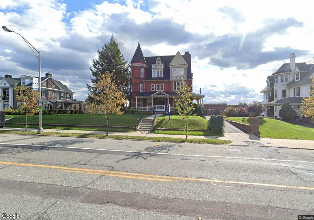
728 E High St Pottstown, PA 19464
East End South Neighborhood
--
Bed
2
Baths
8,102
Sq Ft
0.49
Acres
About This Home
This home is located at 728 E High St, Pottstown, PA 19464. 728 E High St is a home located in Montgomery County with nearby schools including Pottstown Middle School, Pottstown Senior High School, and Saint Aloysius Parish School.
Ownership History
Date
Name
Owned For
Owner Type
Purchase Details
Closed on
Jun 12, 2008
Sold by
Forge First Llc
Bought by
Orbit Properties Llc
Home Financials for this Owner
Home Financials are based on the most recent Mortgage that was taken out on this home.
Original Mortgage
$658,750
Outstanding Balance
$423,149
Interest Rate
6.07%
Mortgage Type
Commercial
Purchase Details
Closed on
Jan 11, 2008
Sold by
Herb Thomas G Assocs
Bought by
Forge First Llc
Home Financials for this Owner
Home Financials are based on the most recent Mortgage that was taken out on this home.
Original Mortgage
$552,500
Interest Rate
6.14%
Mortgage Type
Commercial
Create a Home Valuation Report for This Property
The Home Valuation Report is an in-depth analysis detailing your home's value as well as a comparison with similar homes in the area
Home Values in the Area
Average Home Value in this Area
Purchase History
| Date | Buyer | Sale Price | Title Company |
|---|---|---|---|
| Orbit Properties Llc | $1,050,000 | None Available | |
| Forge First Llc | $650,000 | None Available |
Source: Public Records
Mortgage History
| Date | Status | Borrower | Loan Amount |
|---|---|---|---|
| Open | Orbit Properties Llc | $658,750 | |
| Previous Owner | Forge First Llc | $552,500 |
Source: Public Records
Tax History Compared to Growth
Tax History
| Year | Tax Paid | Tax Assessment Tax Assessment Total Assessment is a certain percentage of the fair market value that is determined by local assessors to be the total taxable value of land and additions on the property. | Land | Improvement |
|---|---|---|---|---|
| 2025 | $12,961 | $211,190 | $95,380 | $115,810 |
| 2024 | $12,961 | $211,190 | $95,380 | $115,810 |
| 2023 | $12,785 | $211,190 | $95,380 | $115,810 |
| 2022 | $12,719 | $211,190 | $95,380 | $115,810 |
| 2021 | $12,573 | $211,190 | $95,380 | $115,810 |
| 2020 | $12,353 | $211,190 | $95,380 | $115,810 |
| 2019 | $12,070 | $211,190 | $95,380 | $115,810 |
| 2018 | $8,580 | $211,190 | $95,380 | $115,810 |
| 2017 | $11,286 | $211,190 | $95,380 | $115,810 |
| 2016 | $11,205 | $211,190 | $95,380 | $115,810 |
| 2015 | $11,134 | $211,190 | $95,380 | $115,810 |
| 2014 | $11,134 | $211,190 | $95,380 | $115,810 |
Source: Public Records
Map
Nearby Homes
- 764 Queen St
- 639 E High St
- 851 Queen St
- 854 Queen St
- 839 South St Unit 112
- 847 South St Unit 93
- 851 South St
- 866 E High St
- 627 Chestnut St
- 651 Walnut St
- 526 Chestnut St
- 564 Walnut St
- 648 Lincoln Ave
- 63 Edgewood St
- 428 South St
- 422 King St
- 426 Cherry St
- 511 Beech St
- 110 S Franklin St
- 570 Jefferson Ave