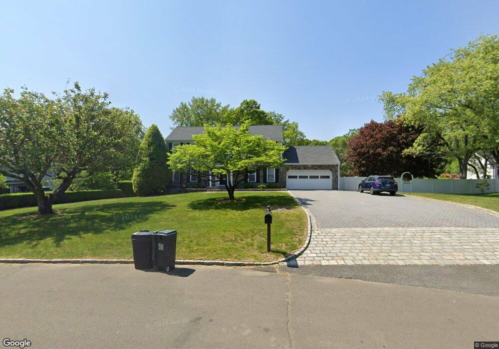
73 Angus Rd N Greenwich, CT 06831
Pemberwick NeighborhoodEstimated Value: $2,156,000 - $2,769,000
4
Beds
3
Baths
3,072
Sq Ft
$818/Sq Ft
Est. Value
About This Home
This home is located at 73 Angus Rd N, Greenwich, CT 06831 and is currently estimated at $2,513,004, approximately $818 per square foot. 73 Angus Rd N is a home located in Fairfield County with nearby schools including Glenville School, Western Middle School, and Greenwich High School.
Ownership History
Date
Name
Owned For
Owner Type
Purchase Details
Closed on
Jun 30, 2021
Sold by
Minio Joseph C
Bought by
Minio Alissa R and Minio Joseph C
Current Estimated Value
Purchase Details
Closed on
May 1, 2020
Sold by
Cathy J Minio Ret
Bought by
Minio Joseph C
Purchase Details
Closed on
Sep 13, 2018
Sold by
Minio Joseph C and Minio Cathy J
Bought by
Cathy J Minio Ret
Purchase Details
Closed on
Dec 17, 1974
Bought by
Minio Joseph C and Minio Cathy J
Create a Home Valuation Report for This Property
The Home Valuation Report is an in-depth analysis detailing your home's value as well as a comparison with similar homes in the area
Home Values in the Area
Average Home Value in this Area
Purchase History
| Date | Buyer | Sale Price | Title Company |
|---|---|---|---|
| Minio Alissa R | -- | None Available | |
| Minio Joseph C | -- | None Available | |
| Cathy J Minio Ret | -- | -- | |
| Minio Joseph C | -- | -- |
Source: Public Records
Tax History Compared to Growth
Tax History
| Year | Tax Paid | Tax Assessment Tax Assessment Total Assessment is a certain percentage of the fair market value that is determined by local assessors to be the total taxable value of land and additions on the property. | Land | Improvement |
|---|---|---|---|---|
| 2025 | $13,548 | $1,096,200 | $739,410 | $356,790 |
| 2024 | $13,084 | $1,096,200 | $739,410 | $356,790 |
| 2023 | $12,755 | $1,096,200 | $739,410 | $356,790 |
| 2022 | $12,639 | $1,096,200 | $739,410 | $356,790 |
| 2021 | $12,744 | $1,058,470 | $668,990 | $389,480 |
| 2020 | $12,723 | $1,058,470 | $668,990 | $389,480 |
| 2019 | $12,850 | $1,058,470 | $668,990 | $389,480 |
| 2018 | $13,093 | $1,058,470 | $668,990 | $389,480 |
| 2017 | $12,722 | $1,058,470 | $668,990 | $389,480 |
| 2016 | $12,521 | $1,058,470 | $668,990 | $389,480 |
| 2015 | $14,250 | $1,194,970 | $933,940 | $261,030 |
| 2014 | $13,839 | $1,190,420 | $933,940 | $256,480 |
Source: Public Records
Map
Nearby Homes
- 20 Sherwood Farm Ln
- 626 W Lyon Farm Dr
- 608 W Lyon Farm Dr
- 39 Homestead Rd
- 21 Calhoun Dr
- 351 Pemberwick Rd Unit 111
- 301 River W
- 12 Glenville St Unit 108
- 93 Greenwich Hills Dr
- 40 Moshier St
- 70 Glenville St
- 52 Almira Dr Unit D
- 34 Edgewood Dr
- 107 Pemberwick Rd
- 7 Curt Terrace
- 14 Meadow Dr
- 8 Fox Run Ln
- 3 Green Ln
- 26 Shady Ln