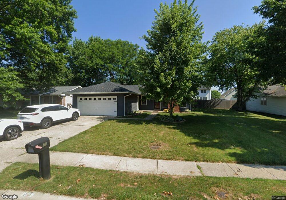
73 Mccarthy Dr Springfield, IL 62702
Estimated Value: $204,235 - $224,000
3
Beds
2
Baths
1,438
Sq Ft
$151/Sq Ft
Est. Value
About This Home
This home is located at 73 Mccarthy Dr, Springfield, IL 62702 and is currently estimated at $217,059, approximately $150 per square foot. 73 Mccarthy Dr is a home located in Sangamon County with nearby schools including Dubois Elementary School, U.S. Grant Middle School, and Springfield High School.
Ownership History
Date
Name
Owned For
Owner Type
Purchase Details
Closed on
Dec 15, 2022
Sold by
Sonneborn Thomas F and Sonneborn Becky S
Bought by
Jj9 Properties Llc
Current Estimated Value
Home Financials for this Owner
Home Financials are based on the most recent Mortgage that was taken out on this home.
Original Mortgage
$348,000
Outstanding Balance
$88,805
Interest Rate
6.95%
Mortgage Type
New Conventional
Estimated Equity
$128,254
Purchase Details
Closed on
Jan 12, 2022
Sold by
Sonneborn Thomas F
Bought by
Sonneborn Thomas F and Dragoo Becky S
Purchase Details
Closed on
Apr 1, 2011
Create a Home Valuation Report for This Property
The Home Valuation Report is an in-depth analysis detailing your home's value as well as a comparison with similar homes in the area
Purchase History
| Date | Buyer | Sale Price | Title Company |
|---|---|---|---|
| Jj9 Properties Llc | -- | -- | |
| Sonneborn Thomas F | -- | None Listed On Document | |
| -- | $125,000 | -- |
Source: Public Records
Mortgage History
| Date | Status | Borrower | Loan Amount |
|---|---|---|---|
| Open | Jj9 Properties Llc | $348,000 |
Source: Public Records
Tax History
| Year | Tax Paid | Tax Assessment Tax Assessment Total Assessment is a certain percentage of the fair market value that is determined by local assessors to be the total taxable value of land and additions on the property. | Land | Improvement |
|---|---|---|---|---|
| 2024 | $4,720 | $56,196 | $9,496 | $46,700 |
| 2023 | $4,538 | $51,330 | $8,674 | $42,656 |
| 2022 | $3,347 | $48,348 | $8,229 | $40,119 |
| 2021 | $3,199 | $46,538 | $7,921 | $38,617 |
| 2020 | $3,137 | $46,608 | $7,933 | $38,675 |
| 2019 | $3,075 | $46,445 | $7,905 | $38,540 |
| 2018 | $2,739 | $43,420 | $7,865 | $35,555 |
| 2017 | $2,671 | $42,858 | $7,763 | $35,095 |
| 2016 | $2,605 | $42,233 | $7,650 | $34,583 |
| 2015 | $2,569 | $41,729 | $7,559 | $34,170 |
| 2014 | $2,805 | $41,459 | $7,510 | $33,949 |
| 2013 | $2,742 | $39,843 | $7,511 | $32,332 |
Source: Public Records
Map
Nearby Homes
- 812 Roanoke Dr
- 6 Redwood Ln
- 160 S Durkin Dr Unit 4
- 243 S Durkin Dr Unit 24
- 36 Trailridge Ln Unit 152
- 804 Fairfax Ct
- 107 Collier Dr
- 2651 W Lawrence Ave Unit 2
- 1038 N Koke Mill Rd
- 2510 & 2518 W Jefferson St
- 504 Brandywine Rd
- 3400 Briana Dr
- 3229 W Point Dr
- 2900 W Lawrence Ave
- 1913 Jeanette Ln Unit 8
- 1914 Jeanette Ln Unit 6
- 3424 Bluff Rd
- 2309 W Lawrence Ave
- 2011 W Jefferson St
- 3613 Briana Dr
- 77 Mccarthy Dr
- 69 Mccarthy Dr
- 2616 Hazelnut Dr
- 81 Mccarthy Dr
- 2620 Hazelnut Dr
- 68 Mccarthy Dr
- 65 Mccarthy Dr
- 85 Mccarthy Dr
- 2612 Hazelnut Dr
- 64 Mccarthy Dr
- 2624 Hazelnut Dr
- 241 Glasgow Dr
- 2608 Hazelnut Dr
- 62 N Oxford Rd
- 237 Glasgow Dr
- 80 Mccarthy Dr
- 232 Glasgow Dr
- 2604 Hazelnut Dr
- 61 N Oxford Rd
- 57 N Oxford Rd
Your Personal Tour Guide
Ask me questions while you tour the home.