
Seller's Agent in 2025
Angie Burdette Diatelevi
Chinatti Realty Group, Inc.
(612) 414-5670
24 Total Sales
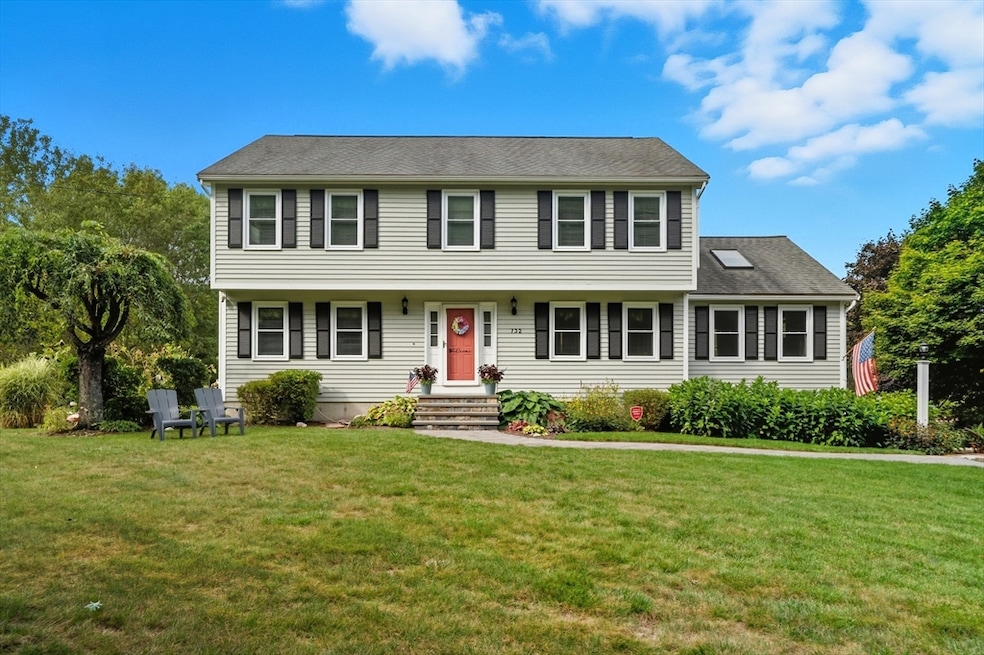


Welcome to 732 Lincoln Street – where comfort meets convenience! This spacious 4-bedroom, 2.5-bath Colonial sits on an oversized yard, perfect for entertaining, gardening, or simply relaxing by the sparkling inground pool. Inside, the inviting eat-in kitchen flows seamlessly into a formal dining room, making gatherings a breeze. A bright and open floor plan offers both versatility and function, with plenty of room for today’s lifestyle. Upstairs, you’ll find four generously sized bedrooms, providing space for everyone. Additional highlights include a 2-car garage for convenience, a new boiler for peace of mind, and a layout designed to balance everyday living with special occasions. Don’t miss this opportunity to own a home that checks all the boxes – space, updates, and outdoor living at its best! 732 Lincoln Street is waiting to welcome you home.
Last Agent to Sell the Property
Chinatti Realty Group, Inc. Listed on: 10/09/2025
| Date | Type | Sale Price | Title Company |
|---|---|---|---|
| Quit Claim Deed | $780,000 | -- | |
| Quit Claim Deed | -- | None Available | |
| Quit Claim Deed | -- | None Available | |
| Deed | $290,000 | -- | |
| Deed | $244,900 | -- |
| Date | Status | Loan Amount | Loan Type |
|---|---|---|---|
| Open | $624,000 | New Conventional | |
| Previous Owner | $321,500 | No Value Available | |
| Previous Owner | $50,000 | No Value Available | |
| Previous Owner | $322,500 | No Value Available |
| Date | Event | Price | List to Sale | Price per Sq Ft |
|---|---|---|---|---|
| 12/19/2025 12/19/25 | Sold | $780,000 | -2.5% | $327 / Sq Ft |
| 11/10/2025 11/10/25 | Pending | -- | -- | -- |
| 10/09/2025 10/09/25 | For Sale | $799,900 | -- | $335 / Sq Ft |
| Year | Tax Paid | Tax Assessment Tax Assessment Total Assessment is a certain percentage of the fair market value that is determined by local assessors to be the total taxable value of land and additions on the property. | Land | Improvement |
|---|---|---|---|---|
| 2025 | $8,860 | $762,500 | $246,200 | $516,300 |
| 2024 | $8,390 | $711,600 | $246,200 | $465,400 |
| 2023 | $7,917 | $629,300 | $256,800 | $372,500 |
| 2022 | $7,601 | $541,000 | $212,200 | $328,800 |
| 2021 | $6,931 | $473,100 | $208,200 | $264,900 |
| 2020 | $6,904 | $475,800 | $223,700 | $252,100 |
| 2019 | $6,662 | $454,400 | $202,300 | $252,100 |
| 2018 | $6,425 | $438,600 | $212,100 | $226,500 |
| 2017 | $6,138 | $421,000 | $194,500 | $226,500 |
| 2016 | $6,180 | $426,200 | $207,400 | $218,800 |
| 2015 | $5,966 | $402,000 | $183,200 | $218,800 |
| 2014 | $5,659 | $391,600 | $172,800 | $218,800 |
Seller's Agent in 2025
Angie Burdette Diatelevi
Chinatti Realty Group, Inc.
(612) 414-5670
24 Total Sales
Buyer's Agent in 2025
Jodi Kairit
Berkshire Hathaway HomeServices Page Realty
(508) 523-5890
65 Total Sales
Source: MLS Property Information Network (MLS PIN)
MLS Number: 73441676
APN: FRAN-000219-000000-000019
Disclaimer: Certain information contained herein is derived from information provided by parties other than Homes.com. All information provided is deemed reliable, but is not guaranteed to be accurate and should be independently verified.
![]() The property listing data and information, or the Images, set forth herein were provided to MLS Property Information Network, Inc. from third party sources, including sellers, lessors and public records, and were compiled by MLS Property Information Network, Inc. The property listing data and information, and the Images, are for the personal, non-commercial use of consumers having a good faith interest in purchasing or leasing listed properties of the type displayed to them and may not be used for any purpose other than to identify prospective properties which such consumers may have a good faith interest in purchasing or leasing. MLS Property Information Network, Inc. and its subscribers disclaim any and all representations and warranties as to the accuracy of the property listing data and information, or as to the accuracy of any of the Images, set forth herein.
The property listing data and information, or the Images, set forth herein were provided to MLS Property Information Network, Inc. from third party sources, including sellers, lessors and public records, and were compiled by MLS Property Information Network, Inc. The property listing data and information, and the Images, are for the personal, non-commercial use of consumers having a good faith interest in purchasing or leasing listed properties of the type displayed to them and may not be used for any purpose other than to identify prospective properties which such consumers may have a good faith interest in purchasing or leasing. MLS Property Information Network, Inc. and its subscribers disclaim any and all representations and warranties as to the accuracy of the property listing data and information, or as to the accuracy of any of the Images, set forth herein.
Ask me questions while you tour the home.