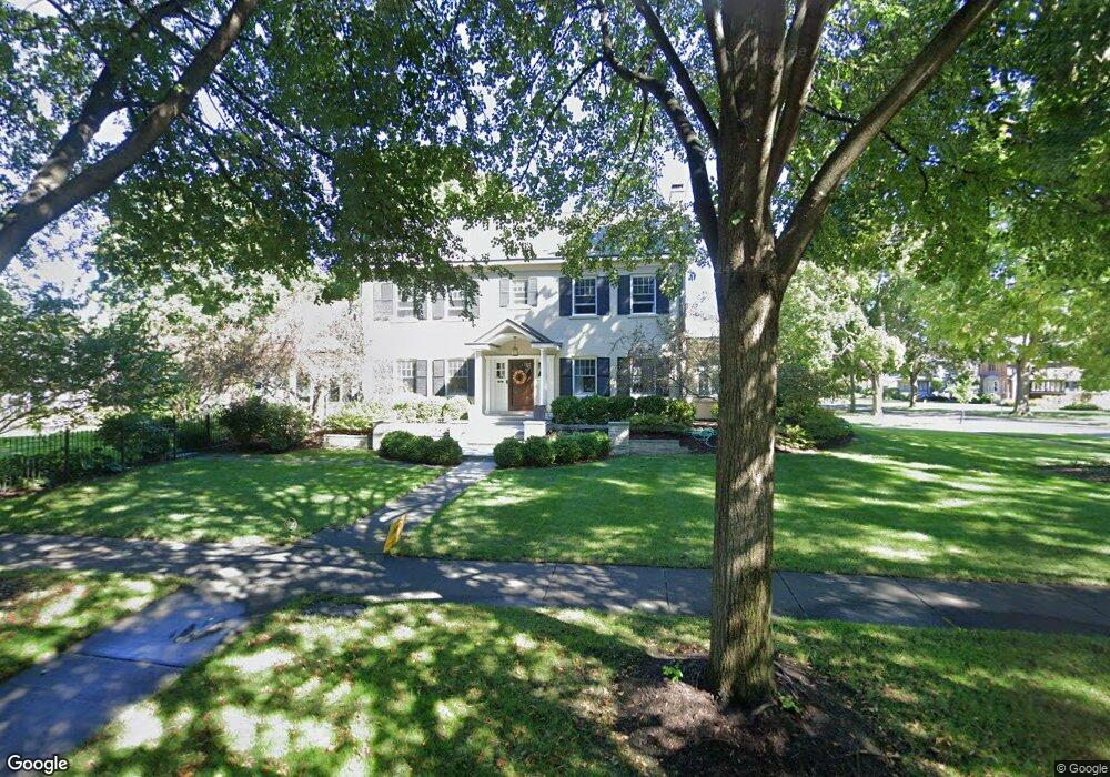
7350 Oak Ave River Forest, IL 60305
Estimated Value: $954,000 - $1,056,000
3
Beds
2
Baths
2,611
Sq Ft
$384/Sq Ft
Est. Value
About This Home
This home is located at 7350 Oak Ave, River Forest, IL 60305 and is currently estimated at $1,002,348, approximately $383 per square foot. 7350 Oak Ave is a home located in Cook County with nearby schools including Roosevelt Middle School, Lincoln Elementary School, and Oak Park and River Forest High School.
Ownership History
Date
Name
Owned For
Owner Type
Purchase Details
Closed on
Oct 8, 2009
Sold by
Flynn Michael and Flynn Teresa
Bought by
Flynn Michael J and Flynn Teresa L
Current Estimated Value
Purchase Details
Closed on
Mar 26, 2004
Sold by
Prevolos Michael P and Prevolos Elizabeth R
Bought by
Flynn Michael and Flynn Terri
Home Financials for this Owner
Home Financials are based on the most recent Mortgage that was taken out on this home.
Original Mortgage
$333,700
Interest Rate
6.37%
Mortgage Type
Unknown
Purchase Details
Closed on
Dec 1, 1993
Sold by
Minnick James S and Minnick Ruth S
Bought by
Prevolos Michael P and Prevolos Elizabeth R
Home Financials for this Owner
Home Financials are based on the most recent Mortgage that was taken out on this home.
Original Mortgage
$280,000
Interest Rate
6.95%
Create a Home Valuation Report for This Property
The Home Valuation Report is an in-depth analysis detailing your home's value as well as a comparison with similar homes in the area
Home Values in the Area
Average Home Value in this Area
Purchase History
| Date | Buyer | Sale Price | Title Company |
|---|---|---|---|
| Flynn Michael J | -- | None Available | |
| Flynn Michael | $675,500 | Prairie Title | |
| Prevolos Michael P | $233,333 | Land Title Group |
Source: Public Records
Mortgage History
| Date | Status | Borrower | Loan Amount |
|---|---|---|---|
| Previous Owner | Flynn Michael | $333,700 | |
| Previous Owner | Prevolos Michael P | $280,000 |
Source: Public Records
Tax History
| Year | Tax Paid | Tax Assessment Tax Assessment Total Assessment is a certain percentage of the fair market value that is determined by local assessors to be the total taxable value of land and additions on the property. | Land | Improvement |
|---|---|---|---|---|
| 2025 | $22,171 | $81,351 | $20,332 | $61,019 |
| 2024 | $22,171 | $81,351 | $20,332 | $61,019 |
| 2023 | $19,846 | $87,000 | $20,332 | $66,668 |
| 2022 | $19,846 | $64,880 | $17,595 | $47,285 |
| 2021 | $19,141 | $64,879 | $17,595 | $47,284 |
| 2020 | $18,772 | $64,879 | $17,595 | $47,284 |
| 2019 | $19,191 | $65,248 | $16,031 | $49,217 |
| 2018 | $18,573 | $66,632 | $16,031 | $50,601 |
| 2017 | $19,472 | $69,870 | $16,031 | $53,839 |
| 2016 | $17,761 | $57,707 | $13,294 | $44,413 |
| 2015 | $18,341 | $60,658 | $13,294 | $47,364 |
| 2014 | $17,844 | $64,209 | $13,294 | $50,915 |
| 2013 | $16,149 | $59,865 | $13,294 | $46,571 |
Source: Public Records
Map
Nearby Homes
- 734 Bonnie Brae Place
- 7346 Lake St Unit 2W
- 7346 Lake St Unit GW
- 7320 Lake St Unit 1A
- 7204 Oak Ave Unit 1NW
- 7210 Oak Ave Unit 4SW
- 7200 Oak Ave Unit 3NW
- 1125 Erie St
- 300 N Maple Ave
- 227 N Marion St
- 1124 Lake St Unit 511
- 1103 Holley Ct Unit 207
- 412 N Marion St Unit 1A
- 420 N Marion St
- 7521 Brown Ave Unit G
- 940 Bonnie Brae Place
- 35 Elgin Ave Unit A
- 407 Ashland Ave Unit 3G
- 411 Ashland Ave Unit 1A
- 7415 Dixon St
- 710 Clinton Place
- 714 Clinton Place
- 632 Clinton Place
- 718 Clinton Place
- 707 William St
- 628 Clinton Place
- 711 William St
- 633 Clinton Place
- 722 Clinton Place
- 715 William St
- 624 Clinton Place
- 633 William St
- 629 Clinton Place
- 7314 Oak Ave
- 719 William St
- 707 Clinton Place
- 726 Clinton Place
- 629 William St
- 715 Clinton Place
- 625 Clinton Place
Your Personal Tour Guide
Ask me questions while you tour the home.