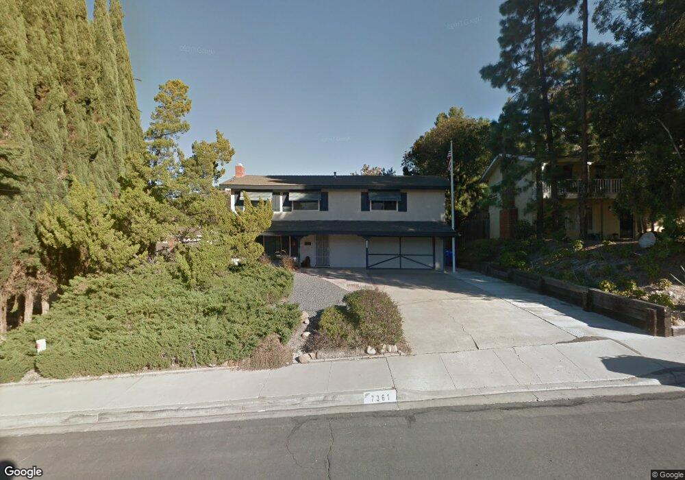
7361 Viar Ave San Diego, CA 92120
Allied Gardens NeighborhoodEstimated Value: $1,123,432 - $1,243,000
5
Beds
3
Baths
1,800
Sq Ft
$656/Sq Ft
Est. Value
About This Home
This home is located at 7361 Viar Ave, San Diego, CA 92120 and is currently estimated at $1,180,358, approximately $655 per square foot. 7361 Viar Ave is a home located in San Diego County with nearby schools including Marvin Elementary School, Lewis Middle School, and Patrick Henry High School.
Ownership History
Date
Name
Owned For
Owner Type
Purchase Details
Closed on
Apr 16, 2024
Sold by
Cox Eileen Butler and Butler-Cox Eileen
Bought by
Cox Family 2024 Trust and Cox
Current Estimated Value
Purchase Details
Closed on
Aug 29, 2022
Sold by
Jacqueline F Butler Trust and Cox Eileen Butler
Bought by
Butler Cox A and Butler James Neve
Purchase Details
Closed on
Jun 17, 2004
Sold by
Butler Jacqueline Francis
Bought by
Butler Jacqueline F
Purchase Details
Closed on
Nov 19, 2001
Sold by
Butler James Neve
Bought by
Butler Jacqueline Francis
Create a Home Valuation Report for This Property
The Home Valuation Report is an in-depth analysis detailing your home's value as well as a comparison with similar homes in the area
Home Values in the Area
Average Home Value in this Area
Purchase History
| Date | Buyer | Sale Price | Title Company |
|---|---|---|---|
| Cox Family 2024 Trust | -- | None Listed On Document | |
| Butler Cox A | -- | None Listed On Document | |
| Butler Jacqueline F | -- | -- | |
| Butler Jacqueline Francis | -- | -- |
Source: Public Records
Tax History Compared to Growth
Tax History
| Year | Tax Paid | Tax Assessment Tax Assessment Total Assessment is a certain percentage of the fair market value that is determined by local assessors to be the total taxable value of land and additions on the property. | Land | Improvement |
|---|---|---|---|---|
| 2025 | $964 | $84,261 | $21,451 | $62,810 |
| 2024 | $964 | $82,610 | $21,031 | $61,579 |
| 2023 | $940 | $80,991 | $20,619 | $60,372 |
| 2022 | $999 | $79,404 | $20,215 | $59,189 |
| 2021 | $992 | $77,848 | $19,819 | $58,029 |
| 2020 | $894 | $77,050 | $19,616 | $57,434 |
| 2019 | $877 | $75,540 | $19,232 | $56,308 |
| 2018 | $820 | $74,059 | $18,855 | $55,204 |
| 2017 | $80 | $72,608 | $18,486 | $54,122 |
| 2016 | $783 | $71,185 | $18,124 | $53,061 |
| 2015 | $771 | $70,116 | $17,852 | $52,264 |
| 2014 | $758 | $68,744 | $17,503 | $51,241 |
Source: Public Records
Map
Nearby Homes
- 7391 Margerum Ave
- 7310 Margerum Ave
- 5908 Highplace Dr
- 5885 Laramie Way
- 5564 Fontaine St
- 7760 Margerum Ave Unit 124
- 7740 Margerum Ave Unit 204
- 7760 Margerum Ave Unit 126
- 7653 Mission Gorge Rd Unit 50
- 7737 Margerum Ave Unit 205
- 8318 Ridge Route Rd
- 6221 Brynwood Ct
- 5468 Princess View Place
- 6310 Decanture St
- 8306 High Winds Way
- 5449 Chaparajos Ct
- 6832 Lazy Clouds Point
- 6329 Caminito Estrellado
- 6817 Birchwood St
- 7890 Mission Vista Dr
- 7351 Viar Ave
- 7371 Viar Ave
- 7380 Margerum Ave
- 7378 Margerum Ave
- 7388 Margerum Ave
- 7341 Viar Ave
- 7391 Viar Ave
- 7374 Margerum Ave
- 7356 Viar Ave
- 7366 Viar Ave
- 7344 Viar Ave
- 7331 Viar Ave
- 7332 Viar Ave
- 7370 Margerum Ave
- 7386 Viar Ave
- 7321 Viar Ave
- 7381 Margerum Ave
- 7404 Margerum Ave
- 5926 Sallisaw Ct
- 7316 Viar Ave