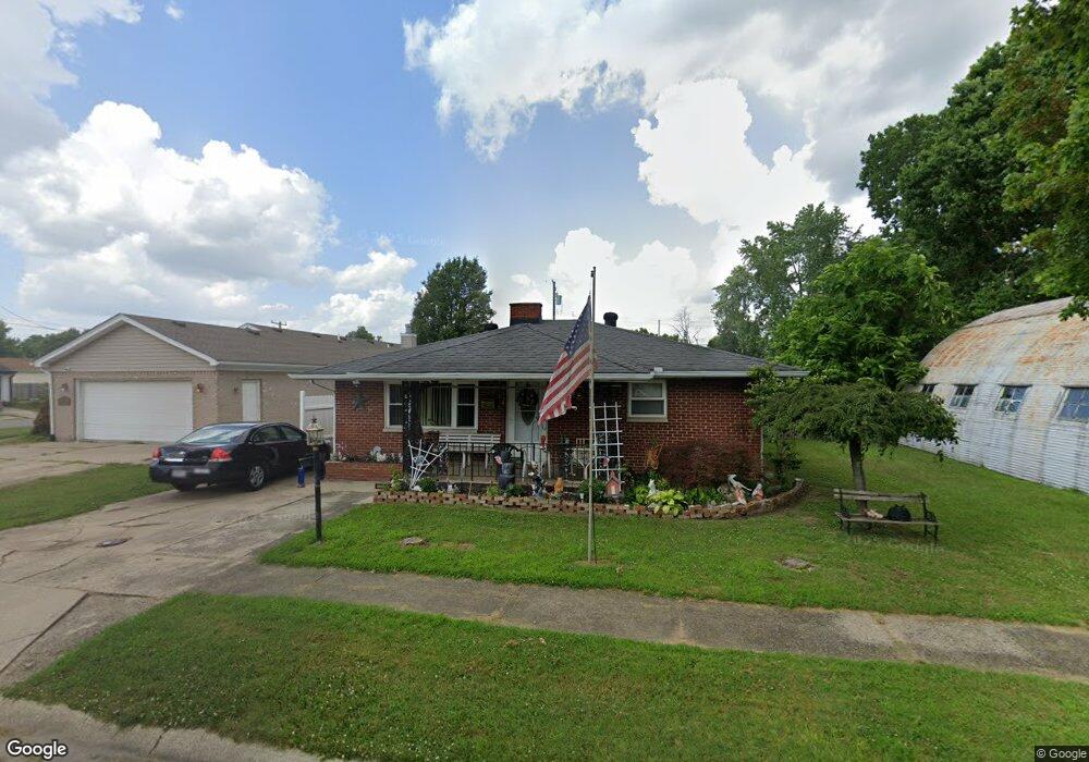
737 Forest Ave Franklin, OH 45005
Estimated Value: $137,935 - $172,000
2
Beds
1
Bath
1,024
Sq Ft
$152/Sq Ft
Est. Value
About This Home
This home is located at 737 Forest Ave, Franklin, OH 45005 and is currently estimated at $155,484, approximately $151 per square foot. 737 Forest Ave is a home located in Warren County with nearby schools including Franklin High School.
Ownership History
Date
Name
Owned For
Owner Type
Purchase Details
Closed on
Oct 16, 2008
Sold by
Clark Christine N and Clark Herbert
Bought by
Clark Herbert and Clark Christine N
Current Estimated Value
Home Financials for this Owner
Home Financials are based on the most recent Mortgage that was taken out on this home.
Original Mortgage
$107,533
Outstanding Balance
$68,614
Interest Rate
5.94%
Mortgage Type
FHA
Estimated Equity
$86,870
Purchase Details
Closed on
Jul 16, 2004
Sold by
Napier Christine D
Bought by
Napier Christine D and Guthrie Charles
Home Financials for this Owner
Home Financials are based on the most recent Mortgage that was taken out on this home.
Original Mortgage
$85,000
Interest Rate
7.4%
Mortgage Type
New Conventional
Purchase Details
Closed on
Nov 25, 1998
Sold by
Fisher Alice
Bought by
Napier Christine D
Create a Home Valuation Report for This Property
The Home Valuation Report is an in-depth analysis detailing your home's value as well as a comparison with similar homes in the area
Home Values in the Area
Average Home Value in this Area
Purchase History
| Date | Buyer | Sale Price | Title Company |
|---|---|---|---|
| Clark Herbert | -- | Sterling Land Title | |
| Napier Christine D | -- | Accurate Title Solutions | |
| Napier Christine D | $18,000 | -- |
Source: Public Records
Mortgage History
| Date | Status | Borrower | Loan Amount |
|---|---|---|---|
| Open | Clark Herbert | $107,533 | |
| Closed | Napier Christine D | $85,000 | |
| Closed | Napier Christine D | -- |
Source: Public Records
Tax History
| Year | Tax Paid | Tax Assessment Tax Assessment Total Assessment is a certain percentage of the fair market value that is determined by local assessors to be the total taxable value of land and additions on the property. | Land | Improvement |
|---|---|---|---|---|
| 2025 | $1,806 | $37,670 | $2,420 | $35,250 |
| 2024 | $1,806 | $37,670 | $2,420 | $35,250 |
| 2023 | $1,558 | $29,379 | $2,331 | $27,048 |
| 2022 | $1,528 | $29,379 | $2,331 | $27,048 |
| 2021 | $1,450 | $29,379 | $2,331 | $27,048 |
| 2020 | $1,393 | $24,896 | $1,974 | $22,922 |
| 2019 | $769 | $24,896 | $1,974 | $22,922 |
| 2018 | $772 | $24,896 | $1,974 | $22,922 |
| 2017 | $857 | $24,511 | $1,981 | $22,530 |
| 2016 | $875 | $24,511 | $1,981 | $22,530 |
| 2015 | $875 | $24,511 | $1,981 | $22,530 |
| 2014 | $909 | $24,510 | $1,980 | $22,530 |
| 2013 | $723 | $27,160 | $2,190 | $24,970 |
Source: Public Records
Map
Nearby Homes
Your Personal Tour Guide
Ask me questions while you tour the home.